Cuernavaca
| Cuernavaca, Morelos | ||||||||
|---|---|---|---|---|---|---|---|---|
| City and Municipality | ||||||||
Cuernavaca City | ||||||||
| ||||||||
| Nickname(s): "City of Eternal Spring" | ||||||||
|
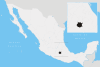
Cuernavaca, Morelos Location in Mexico | ||||||||
| Coordinates: 18°55′07″N 99°14′03″W / 18.91861°N 99.23417°W | ||||||||
| Country | Mexico | |||||||
| State | Morelos | |||||||
| Founded | 1200 BC | |||||||
| Municipal Status | 1821 | |||||||
| Government | ||||||||
| • Municipal President | Cuauhtémoc Blanco | |||||||
| Area | ||||||||
| • Municipality | 151.2 km2 (58.4 sq mi) | |||||||
| Elevation (of seat) | 1,510 m (4,950 ft) | |||||||
| Population (2005) Municipality | ||||||||
| • Municipality | 349,102 | |||||||
| • Seat | 332,197 | |||||||
| Time zone | CST (UTC−6) | |||||||
| • Summer (DST) | CDT (UTC−5) | |||||||
| Postal code (of seat) | 62000 | |||||||
| Area code(s) | 777 | |||||||
| Website | (Spanish) /Official site | |||||||

Cuernavaca (![]() kweɾnaˈβaka ; Classical Nahuatl: Cuauhnāhuac [kʷawˈnaːwak] "near the woods") is the capital and largest city of the state of Morelos in Mexico. It was established by the Olmec, "the mother culture" of Mesoamerica, approximately 3200 years ago and is designated as the archaeological site of Gualupita I . The city is located south of Mexico City, from which it may be reached after a drive of approximately 1½ hours using the D-95 Freeway.[1]
kweɾnaˈβaka ; Classical Nahuatl: Cuauhnāhuac [kʷawˈnaːwak] "near the woods") is the capital and largest city of the state of Morelos in Mexico. It was established by the Olmec, "the mother culture" of Mesoamerica, approximately 3200 years ago and is designated as the archaeological site of Gualupita I . The city is located south of Mexico City, from which it may be reached after a drive of approximately 1½ hours using the D-95 Freeway.[1]
Cuernavaca was designated Forest Protection Zone by President Lazaro Cardenas in the 1930s to protect the aquifers, the vegetation and the quality of life of residents both in Mexico City and locally. The city was nicknamed the "City of Eternal Spring" by Alexander von Humboldt in the nineteenth century. It has long been a favorite escape for Mexico City and foreign visitors because of this warm, stable climate and abundant vegetation. Aztec emperors had summer residences there, and today many famous people as well as Mexico City residents maintain homes there.[2][3] Considering its location of just a 1½-hour drive from Mexico City, Cuernavaca traditionally has been a center of Mexican society and glamour, with many of the country's wealthy citizens owning sprawling mansions and haciendas in this cultural haven. Cuernavaca is also host to a large foreign resident population, including large numbers of students who come to study the Spanish language.[4]
The name "Cuernavaca" is derived from the Nahuatl phrase "Cuauhnāhuac" and means "surrounded by or close to trees". The name eventually was Hispanicized to Cuernavaca. The coat-of-arms of the municipality is based on the pre-Columbian pictograph emblem of the city which depicts a tree trunk (cuahuitl) with three branches, with foliage, and four roots colored red. There is a cut in the trunk in the form of a mouth, from which emerges a speech scroll, probably representing the language Nahuatl and by extension the locative suffix "-nāhuac", meaning "near".[5]
The city
City of Eternal Spring
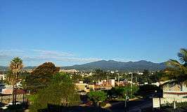
Cuernavaca was nicknamed "city of eternal spring" by Alexander von Humboldt in the nineteenth century.[1] The city is located in a tropical region, but its temperature is kept fairly constant in the 70s (°F). It is located on the southern slope of the Sierra de Chichinautzin mountains. In the morning, warm air flows up the mountains from the valley below and in the late afternoon, cooler air flows down from the higher elevations.[2][5]
This pleasant climate has attracted royalty and nobles since Aztec times. Most of the Aztec emperors called Cuernavaca their summer residence. Foreign princes, archdukes, and other nobles have been attracted to this place because of its flowers, sun, fruits, fresh-water springs, and waterfalls. The Shah of Iran had a house here, as did the Emperor of Ethiopia, Haile Selassie, and late sculptor, John Spencer, a relative of Princess Diana. Although a native of the U.S., Bauhaus designer Michael van Beuren established his residence in a family hacienda in Cuernavaca while fleeing the rise of the Nazi regime in Germany (where he studied and practiced his profession), and a colony of Bauhaus designers grew in the city during World War II.[3]
Cuernavaca metropolitan area
Cuernavaca always has been a popular place for people from Mexico City to escape the city. In the twentieth century, the climate and flora began to attract many foreigners as well. Population increase in this urban area began in 1940, but the metro area was not created, nor recognized, until the 1960s. From this time the population and the extension of the metropolitan area has grown. From 1960 to 1980, the population had grown from 85,620 to 368,166. From the 1980s to the present, the municipalities of Emiliano Zapata, Jiutepec, Temixco, Tepoztlán, Xochitepec, and Yautepec have been added to the metropolitan area. These municipalities have seen the highest rates of growth, however, population and economic activity remains concentrated in the city of Cuernavaca proper.[5] As of 2005, the metropolitan area had a population of 802,371, with 349,102, living in the city proper.[6]
Over the decades since 1970, this metropolitan area has become more economically and socially integrated with the Mexico City metropolitan area. Many people from Mexico City own second homes there for weekend retreats, both for the climate and for the well-developed infrastructure.[2][5] Starting in the 1980s permanent migration of Mexico City residents began, spurred by pollution and crime problems in the capital.
The 1985 Mexico City earthquake also pushed many well-to-do families there, fearful of the next catastrophe. In many of these cases, the main breadwinner commutes each day to work in Mexico City.[1][5] This has produced the great increase in housing developments on the outskirts of the city, especially in the late 1990s and 2000s. This influx has had a positive economic benefit for the city, but has put pressure on the infrastructure as well. 85% of the city of Cuernavaca is dedicated to housing, and much of this is in upper-class housing developments such as Rancho Cortés, Rancho Tetela, and Colonia del Bosque, which are located on the outskirts of the city. Lower-income housing is concentrated in the city proper. Only 2% of the housing in Cuernavaca is in high-rise buildings.[5] Cuernavaca has been called the "Beverly Hills of Mexico"[4] because from just about any elevation in the city, one can see that many of the homes have swimming pools.[1] Cuernavaca is the second city in the world with most pools per capita. [citation needed]
History
The first major culture to inhabit this area was the Tlahuica, whose main settlement was where the city of Cuernavaca is today. The Tlahuicas have inhabited this area at least since the twelfth century.[2]
The first incursions south into the area by peoples of the Valley of Mexico occurred in the twelfth century, when a lord named Xolotl (ruler of Tetzcoco) conquered most of the Valley of Mexico. An allied Chichimeca tribe also moved south into what is now northern Morelos state, making Techintecuitla lord of the Cuernavaca area, with the Tlahuicas concentrated in the nearby towns of Yecapixtla and Yautecatle. According to the Tlatelolco Annals, in 1365, the lord of Cuernavaca, Macuilxochitl, tried to conquer lands as far as the Valley of Mexico, but was met by the lord of Chalco, Tzalcualtitlan, with similar ambitions.[7]
The first Aztec emperor, Acamapichtli, began to expand his empire to the south of the Valley of Mexico and beyond in the 1370s. His successor, Huitzilihuitl, was eager to press on into what is now Morelos state because of the cotton grown there, it was called Tlalnahuatl at that time. He asked to marry the daughter of the ruler of Tlalnahuatl, but was rejected. That rejection started a war that ended with an Aztec victory in 1396. Huitziliuitl then married the princess and Moctezuma I was born of the union. Credit for the conquest of Cuernavaca is given to Acamapichtli in the Mendocino Codex, but later writings cite Itzcóatl, or even Moctezuma I, as conqueror. The conquered dominion, Tlalnahuac, was roughly the size of the modern state of Morelos, and subsequently was renamed as Cuauhnahuc by the Aztecs.[7]
From 1403 to 1426, this province grew in strength, subduing neighboring peoples such as the Coauixcas. Eventually, the province, then ruled by Miquiuix, rebelled against the Aztec Empire. This rebellion was put down by Totoquihuatzin and Netzahualcoyotl in 1433. This area then joined in the conquests of what now are known as Taxco, Tepecuacuilco, and Ocuilán. For tribute purposes, the dominion was divided into two zones, one headed by Cuernavaca and the other by Huaxtepec.[7]
At the time of the Spanish Conquest, Itzohuatzin was governing Cuernavaca. It was a rich city and densely populated, with large farms and its characteristic ravines bridged over. In the center of the city was a large fort, however, this fort and the entire city fell to the Spanish. The Spanish marched on Cuernavaca even before taking the Aztec capital of Tenochtitlan.[8]:338–340 They were led by Gonzalo de Sandoval and he was joined later by the conquistador, Hernán Cortés.[7]
Cortés returned to Cuernavaca in 1523, stopping in Tlaltenango, where he founded the Church of San José and constructed the first sugar plantation. The fertility of these lands compelled the conquistador to found his favorite residence here. Juana de Zúñiga, Cortes's wife, lived in Cuernavaca in the palace that was constructed in 1526. Cortes then moved the hacienda in Tlaltenango to Amatitlan and finally settled in his hacienda at Atlacomulco.[5] The Franciscans arrived in Cuernavaca in 1529 and founded their fifth monastery in New Spain there. This first group included Martín de Lua, Francisco Martínez, Luis Ortiz, Juan de Cervo, Francisco de Soto, Andrés de Córdova, Martín de Jesús, Juan Juárez, Juan de Motolinía, and Juan García de Cervo. Originally they lived at the San Francisquito hermitage, but later they constructed the open-air chapel, Capilla Abierta, at the Church of San José in Tlaltenango. They extended their presence into the neighboring communities of Tetecala, Jiutepec, and Tlaquiltenango, among others, eventually forming the province of Santo Evangelio, which would be part of the province of Mexico in 1543. In 1646, this province was reorganized several times. Cuernavaca and Cuautla became high mayorships which answered directly to the viceregal authorities in Mexico City. In 1786, New Spain was divided into twelve provinces and in 1824, Cuernavaca was initially a district of Mexico City.[7]
During the Mexican War of Independence, José María Morelos was imprisoned at the Palacio de Cortés in November 1815. Agustín de Iturbide's army passed through Cuernavaca to fight Vicente Guerrero in 1820 and came through again in 1821, as the head of the Ejército Trigarante. After Independence and with the Constitution of 1824, the territory now known as the State of Morelos became part of the State of Mexico. Between 1827 and 1829, Cuernavaca was a district of this state. From 1829 to 1833, it was called a prefecture. In 1833, the State of Mexico declared the Atlacomulco Hacienda, which contains the Palacio de Cortés and Cortés's houses in Coyoacán, to be public property.[7]
In 1834, Ignacio Echevarría and José María Tornel drafted the Plan of Cuernavaca, which permitted Antonio López de Santa Anna to disregard the laws protecting church property, exile Valentín Gómez Farías, reopen the university, and dissolve the tribunal that was set to convict Anastasio Bustamante for the assassination of Vicente Guerrero. In the same year, the State of Mexico declared Cuernavaca to be a city.[7]
During the Mexican-American War, Cuernavaca was captured by the Cadwalader Brigade and was forced to pay retributions to the U.S. Army after the Cuernavaca Infantry under Francisco Modesto Olabuibel fell. During the Ayutla Rebellion in 1854, Santa Anna was forced out of the capital of Mexico City in 1855. He moved his government to Cuernavaca, reorganized it, and named a junta to elect an interim president. This junta consisted of Valentín Gómez Farías, Melchor Ocampo, Benito Juárez, Francisco de P. Zendejas, Diego Álvarez, and Joaquín Moreno. They then voted for Alvarez as president. This new president swore to uphold the Plan of Ayutla and his inauguration was celebrated with much pomp in the city.[7] In 1856, the District of Cuernavaca and the District of Mexico were declared separate.[7] During the Three-year War (1858–1860) when conservatives rejected the liberal constitution of 1857, Juan Vicario voiced the cry of "Religión y Fueros" in Cuernavaca on 13 January 1858. In 1861, the Government of the State of Mexico created the districts of Cuernavaca, Morelos, Jonacatepec, Tautepec, and Tetecala.[5]
In order to facilitate operations against the French during the French Intervention, President Juarez divided the State of Mexico into three military districts. The third consisted of the territories of Cuernavaca, Yautepec, Morelos, and Tetecala, with its capital in the city of Cuernavaca. Soon thereafter, this district fell into French hands. Maximilian I converted the Borda Garden into his summer residence and bought land in nearby Acapantzingo to construct a chalet. This prompted the construction of the Mexico-Cuernavaca highway.[7]
When the French-installed monarch fell in 1867, Republican forces under Francisco Leyva, Ignacio Figueroa, and Ignacio Manuel Altamirano laid siege to Cuernavaca, which was defended by General Joaquín Ayestarán. The attackers cut off water supplies to the city and attacked on 3 January, but were met with a long series of street battles throughout the city. During the fighting, the general was killed and the Republican forces withdrew, victorious, to Mexico City, but only after burning a large portion of the city.[7]
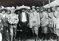
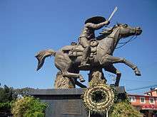
The State of Morelos was created in April 1869, with General Francisco Leyva as its first governor. Cuernavaca was declared the capital of the new state in November of the same year. In 1877, the Toluca-Cuernavaca highway was built and a rail connection created between Cuernavaca and Mexico City. In 1891, the Diocese of Cuernavaca was established by Pope Leo XII, comprising the entire state of Morelos, with Fortino Hipolito y Vera as first bishop of Cuernavaca. The first locomotive to arrive in the city was in 1897 and greeted by President Porfirio Díaz. The Bank of Morelos was founded in 1903. In 1909, the anti-reelection movement was established in Cuernavaca, and by the end of this same year guerilla operations against the Diaz government were headed by Genovevo de la O in Santa María Ahuacatitlán. Emiliano Zapata took over the movement in the south and named De la O in charge of the Cuernavaca area.[7]
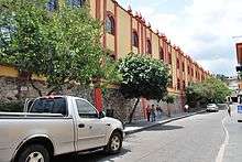
.jpg)
Wealthy North Americans and Europeans established secondary residences in Cuernavaca and took long vacations there or frequently traveled back and forth, while servants maintained the haciendas in their absence. Sometimes, their offspring have made Cuernavaca their permanent residence, creating an enclave of natives with international roots bearing the influence of their cultures. For example, when the American designer, Michael van Beuren fled Germany with members of Bauhaus, where he was practicing his profession, he took up residence at the vacation hacienda of his parents in Cuernavaca, and stayed permanently, establishing his factory nearby and raising his family there. Others in his family began to reside there year 'round. Their children became natives of Mexico.Video on YouTube
In the first decades of the twentieth century, Cuernavaca became a place to vacation and gamble when the Hotel de la Sevla was converted into the Casino de la Selva, which attracted people such as Rita Hayworth, Bugsy Siegel, and Al Capone to Cuernavaca, however, gambling was shut down by Lázaro Cárdenas in 1934. He is the same president who declared the area a ZPG (Forest Protection Zone). The casino hosted very important artistic works, including murals of Alvarez Icaza, Messeguer, and the architecture of Candela. The main vault was considered to be the "Mexican Sistine Chapel" by Nobel Prize author, Gabriel García Márquez.
1936 was the year that Malcolm Lowry wrote his short story, "Under The Volcano", which inspired his 1947 novel of the same name. It is still considered one of the top five greatest novels of the twentieth century, and has never gone out of print. Cuernavaca, or Quaunahuac, as it is called in the novel, and the surrounding area, figure prominently in this great historical novel, where extensive details on Mexican history, culture, topography, and especially, politics and religion figure prominently. The recurrent artifacts are the twin volcanos, Popocatepetl and Iztaccihuatl, and the barranca, symbols of division, death, and rebirth in the city of eternal spring.
In the 1960s, the city was one of the centers of the psychedelic movement. Timothy Leary tried psilocybin mushrooms there in the summer of 1960 and came back regularly to repeat the experience. In 1956, Erich Fromm founded the Sociedad Mexicana de Psicoanálisis and from his house in Cuernavaca promoted new ideas in the field of psychiatry, incorporating Zen Buddhism and "communal psychoanalytic studies" (estudios psicoanalíticos comunitarios). This attracted many artists, composers, architects, and counterculture types here.[3]
More recently the city has seen a very active society dedicated to the preservation of its environment and cultural heritage. The Frente Civico which is now influential throughout the country, along with some 150 other organizations has promoted a boycott against Costco for having destroyed the Casino de la Selva to build a couple of warehouses. One of its members, Professor Jaime Lagunez, (also promoter of Zen buddhism) lobbied a general agreement in the national congress for the purpose of protecting its sixty archeological sites, its vegetation, historic center, and neighboring forests, among other important cultural aspects of the city. (see https://es.scribd.com/document/322348956/Punto-de-Acuerdo). The Frente Civico received the 2004 National Mendez Arceo Human Rights Award for having protected the world cultural heritage found in the city.
Points of Interest
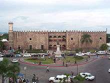
Palace of Cortés
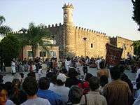
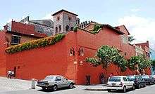
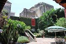
The Palacio de Cortés is east of the Morelos Garden and is considered to be the most representative building of Cuernavaca.[9] Built by Hernán Cortés, it was finished in 1535. It is one of the oldest European-style, civil constructions in the Americas, but is executed in Renaissance style.[5] The series of arches of the central terrace, the battlements, and the thick walls are the most representative aspects of the original construction. It is said that this residence looks much like the mansion built in Santo Domingo by Diego Colón, the son of Christopher Columbus. Just outside the front of the building is an old pyramid base over which Cortés had the structure built,[9] on a hill that dominated the old city.[10] Petroglyphs recovered from the site and from throughout the city are on display. From right to left the petroglyphs are named Lagarto de San Antón, Aguila de Chapultepec, Piedra Chimalli, or Piedra de los Encantos.[9]
After having been the residence of Cortés and his descendents for several centuries, the building became a warehouse, a jail, a military barracks, and then the State Government Palace (until 1969). From 1971 to 1973, the building was restored extensively and today houses the Museo Regional Cuauhnáhuac, dedicated to the history of Morelos State. It often is referred to as, the Palacio. It has ten exhibit halls with maps, illustrations, photographs, works of art, and everyday items from various epochs representing the first human settlements in the state to the present day. It has murals created by Diego Rivera that reflect both Morelos and Mexican history.[9] Adjacent to the Palacio a permanent local handicraft market in which one may purchase silver jewelry, T-shirts, beaded bracelets, pottery, hammocks, blankets, and much more.[11]
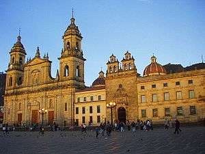
Morelos and Juárez Gardens
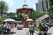
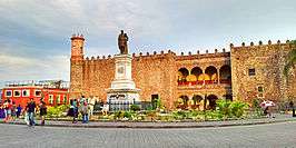
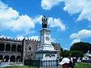
The Juárez and Morelos Gardens are in the center of the city, both of which are plazas lined with trees. Between the two is the State Government Palace, a three story building with a tezontle façade built between 1955 and 1969. The Morelos Garden dates from 1908 and is easily recognizable by the large stone statue of José María Morelos, which is known colloquially as "Morelotes". The Juárez Garden is located to the north of the State Government Palace and is the oldest public square in Cuernavaca.[9] The Garden contains a kiosk from England dating from the end of the nineteenth century.[10] Unlike most main squares in Mexico, neither of these open up the way to the main cathedral. The main cathedral in Cuernavaca is located a few blocks west of the square.[9]
These two gardens or plazas are known colloquially as the "zócalo". Spectacles are often to be seen here and can include people dancing the "danzón" or other popular dances[10] and "estudiantinas" dressed in colonial-era Spanish garb, playing instruments and dancing, and any number of free concerts. Often clowns perform on the zocalo as well, with balloons and tricks for the children and tell double-entendre jokes for the adults. Locals use the plazas to sell products such as honey, yogurt, traditional candies, and crafts. Street food such as corn on the cob, snow cones, candies, fruit smoothies, and more generally are available.[11]
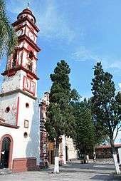
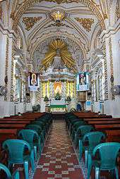
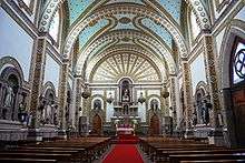
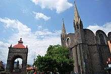
The cathedral
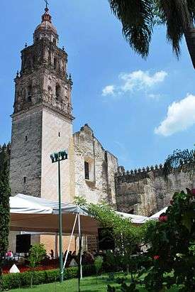
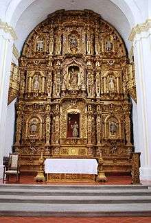
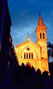
The Cuernavaca Cathedral is the main church of what was the monastery of the Third Order of the Franciscans, called La Asunción, that dates back to the sixteenth century.[9] It sits on the southeast corner of a large atrium, which also contains a number of other chapels that were built at different times and with different architectural styles.[5][10] This complex is located at the intersection of Hidalgo and Morelos streets, a few blocks west of the town center.[9]
The cathedral was built by Cortés to double as a fortress, with cannons mounted above the buttresses.[1] Over time, this church underwent a number of transformations, updating its interior. This was undone in the mid-twentieth century, when restoration work removed all the Neoclassical altars and images. These now are stored in the cathedral's pinacotheca and not available to the public. Restoration work uncovered al fresco murals on the lateral walls, relating to the martyrdom of Philip of Jesus, the first Mexican canonized as a saint. The only other decoration inside this church now is a modern-style crucifix and an image of the Assumption of Mary. This restoration work was carried out by Bishop Sergio Méndz Arceo.[10]
After the Reform Laws in the 1860s, most of the monastery property passed into state, then private hands, leaving only what is now the cathedral and several smaller chapels on a very large atrium. The Revolution Garden was the orchard of the Cathedral,[10] and the cloister with its observatory, is now the Robert Brady Museum.[1] The church became the Cathedral of Cuernavaca in 1891.[5][9][10]
Next to the cathedral is the "open chapel" (capilla abierta) of San José, which is an original structure built in the sixteenth century. It also was rescued and restored by Bishop Méndez Arceo and is one of the oldest constructions on the site. The building consists of a vault with three arches that face the atrium. These arches are supported by a pair of flying buttresses. Inside the arches is an altarpiece dating from the seventeenth century.[5][10]
The main entrance is on Hidalgo street, where one passes between two large chapels called the Chapel of Santa Cruz and the Chapel of the Tercera Orden. The Tercera Orden is considered to be the more valuable artistically of the two, with its highly sculpted early Baroque main and side portals painted in various colors. Inside, there is a later Churrigueresque main altar. A third chapel, called the Chapel of Nuestra Señora de los Dolores is farther into the atrium and near the Open Chapel of San José.[9]
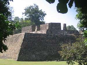
Teopanzolco
Teopanzolco is an archeological site located just east of the historic downtown of Cuernavaca. Its construction is dated to the year 1427, and it was an important ceremonial center during the fifteenth and sixteenth centuries when the native Tlahuicas were dominated by the Aztecs. The site shows significant Aztec influence. It has a large pyramidal base, called the Gran Basamento, topped by two shrines, much like the Templo Mayor in Tenochtitlan. Only the stone columns of these shrines remain today. The teocalli, or sacred plaza, contains fourteen monuments including a circular altar dedicated to the wind deity Ehécatl.[9][10] There are also two concentric structures separated by a moat or ditch. Both might have been dedicated to Quetzalcoatl, the feathered-serpent deity.[5]
Borda Garden
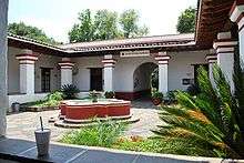
The Borda Garden is located near the cathedral on Morelos Street. Originally, this was a house bought by José de la Borda, the mining magnate of Taxco in the mid-eighteenth century. Later, his son, Manuel de Borda y Verdugo, transformed the grounds of the house into gardens filled with flower and fruit trees to satisfy his passion for botany. These gardens also contain a number of fountains and an artificial lake that were completed in 1783. The complex also contains lodgings, offices, a restaurant, and a nightclub. In 1865, this was the summer home of Emperor Maximilian I and his wife Carlota Amalia. It hosted major political soirées in the nineteenth and twentieth centuries, such as those sponsored by Porfirio Díaz and Emiliano Zapata. Today the area is a public park where the gardens have been maintained and it is possible to take a short boat ride on the lake. The house has been converted into a museum. Six of its halls are dedicated to temporary exhibits while the other seven are devoted to recreating the characteristics of the eighteenth and nineteenth centuries.[9]
The Church of Nuestra Señora de Guadalupe is located next to the Borda Garden, and was constructed by Manuel de la Borda in 1784. It has a Baroque façade and what is considered to be the best cupola in the city. It was the royal chapel of Emperor Maximilian.[9]
Robert Brady Museum
The Robert Brady Museum is on Nezahualcoyotl Street and occupies the building known as the Casa de la Torre, originally part of the monastery of La Asunción.[9] In 1960, it was purchased by the U.S. artist, Robert Brady, who transformed it into his home and a private art and collectible museum.[1] It contains a collection of art and crafts from around the world as well as the original Self-Portrait with Monkey painted by Frida Kahlo. Other works are by artists such as Miguel Cobarruvias, Pelegrí Clavé, María Izquierdo, and Rufino Tamayo. Non-Mexican paintings include those from North America and Europe. Other objects in the collection include antique furniture, African and Indian crafts, and archeological pieces.[10] The collection occupies fourteen rooms of the old house, which has been kept mostly the way it was when Brady died in 1986 and bequeathed the house and its contents to the city.[1][9]
Tlaltenango
Tlaltenango used to be a separate town, but now is a neighborhood of Cuernavaca city. The main attraction there is the church compound containing the Church of San José and the Church of Nuestra Señora de los Milagros de Tlaltenango. San José is one of the oldest churches in Mexico, built between 1521 and 1523. Two centuries later an image of the Virgin appeared to members of this village, prompting the building of the second church. This is the Sanctuary of Nuestra Señora de los Milagros, which was built in 1730, with its bell towers built at the end of the nineteenth century.[9][10]
Hacienda Atlacomulco
The Hacienda de San Antonio Atlacomulco is located south of the Cuernavaca and was established by Hernán Cortés as one of the first sugar plantations in Mexico. Descendants of the Conquistador held the property until the nineteenth century, when it became the property of Lucas Alamán, who modernized the facility. The hacienda lost its surrounding properties during the Mexican Revolution and all that remains is the main house. After a long period of restoration and modification, the hacienda today houses an exclusive hotel, which can accommodate conventions and banquets.[9][10]
Museum of Traditional and Herbal Medicine and the ethnicbotanical garden
South of the city center is Acapantzingo, which had been a separate town, but now is part of the city. A large farm owned by Emperor Maximilian I existed there in the 1860s. It was named Olindo, referring to a character in the poem by Torquato Tasso.[9] The emperor used this property as one of his residences in Cuernavaca, and according to rumor, to enjoy the company of a certain beautiful Indian woman.[10] On this farm and in what was the Pavilion, is now the Museum of Traditional and Herbal Medicine (Museo de Medicina Tradicional). The museum sponsors workshops and classes on the use of plants to make soap, cremes, dyes, decorative objects, and more. Outside is the ethnicbotanical garden with exhibits including 800 species of plants organized by uses, such as the making of textiles, animal feed, condiments, ritual, and others.[9]
Museo Muros
Located a short distance outside the city center is another art museum called the Museo Muros (Avenida Vicente Guerrero 205, Colonia Lomas de Selva). This museum exhibits the art collection of Jacques and Natasha Gelman. Jacques, a Russian émigré, made his fortune as the producer of hit comedies by the legendary Mexican comic, Cantinflas. A good portion of the money he made went into the acquisition of art, which he collected for half a century. Works by Rivera, Kahlo, David Alfaro Siqueiros, Francisco Toledo, Rufino Tamayo, Cisco Jimenez, Gerardo Suter, and Juan Soriano are among the works that could be found there. This museum was closed in 2008.[1] Opened in its place is the Papalote museo del niño an interactive children's museum with up to thirty exhibitions and artistic experiences for children, such as Mindball, Kandinsky Rug, Gigantic Piano, and others.
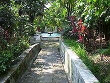
Chapultepec Ecological Park
The Chapultepec Ecological Park is located about four km southeast of the Cuernavaca city center. It contains fresh-water springs, which form the beginning of a river, and is surrounded by large trees called Chapultepec. Before 2003, this area was privately operated under concession as the "Magic Jungle". Today, it is a public park administered by the State Commission of Water and Environment. In addition to a large family picnic area with playgrounds, the park has constructed habitats for monkeys, birds, crocodiles, reptiles, and aquatic plants. It also has a petting zoo, environmental museum, planetarium, house of terror, theatre, and tour train.[9]
Chapitel del Calvario
The Chapitel del Calvario is a church located at the corner of Morelos and Matamoros Streets, which was constructed in 1532. The word "chapitel" means "spire" as the church is named after two spires that define its appearance. It also has a fourteen-meter-high dome. It was constructed in the sixteenth century and was the last building encountered within Cuernavaca, as one left the city on the road to Mexico City. In 1772, this church was dedicated to the Virgin of Guadalupe.[9][10]
El Castillito
Museo de Fotografía Antigua, also known as El Castillito (the little castle), is located one block from the Chapitel del Calvario. It is a very small brick building that dates from the late nineteenth or early twentieth century. It is now a small museum dedicated to antique photographs of the city of Cuernavaca.[9][10]
Salto de San Antón
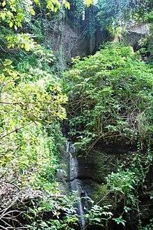
The Salto de San Anton is a large ravine with a small waterfall that is located within the city limits of Cuernavaca. The waterfall is 36 metres (118 feet) high, with its water coming from a small tributary of the Zempoala River. The vertical walls of the ravine are of basalt and broad-leafed vegetation grows in nooks and crannies of the stone. A series of stairs and platforms have been built to enable access to the waterfall area from the park above. Unfortunately, a lot of trash gets dumped there.[9][10]
Festivals and dance
The Feria de la Flor was established in 1965 as a festival that is held from 2 to 12 May. In the Borda Garden, flower growers from all over Mexico come to exhibit their wares, competing for an annual prize. The event also has traditional fair rides, cockfights, and horse competitions as well as music and sociocultural events. Neighborhood celebrations are held in Cuernavaca, mostly for patron saints, they include 15 May, the feast of San Isidro Labrador; 13 June, the feast of San Antonio in the neighborhood of San Antón, with Aztec dances; 6 August, the feast of the Savior or the Transfiguration in Ocotepec, featuring the Moors and Christians dance, mole, and pulque; 10 August the feast of San Lorenzo in Chamilpa; 15 August, the festival of the Assumption of Mary in Santa María Ahuacatilán; and 8 September, Festival of Nuestra Señora de los Milagros in Tlaltenango. Since 1965, the city Cuernavaca has had a carnival as well.[5]
The Huehuechis, a dance group, was started in Cuernavaca in 1870 by a group of young people. They dressed up in old boots and clothes, covering their faces with cloth, dancing sponteaneously in the streets with whistles and shouts. The name comes from a Nahuatl word for old, worn-out clothing. The event spread to other municipalities. It became popular enough among participants and spectators alike to be organized formally in 1871, when it became a traditional way to celebrate the days just before Lent, or the Sunday, Monday, and Tuesday of Carnival. The tradition spread to Tepoztlan, where it became even more famous after the people there modified the clothing worn, adding masks with beards and large mustaches. The dance there was renamed "Chinelos". This new version became a fixture at the carnaval of Yautepec and other towns in Morelos as well.[5]
Tallera Siqueiros
The Sala de Arte Público Siqueiros is a museum and research center, but is also hosts countless of lectures and panel discussions on contemporary art. The SAPS is dedicated to give continuity to the technical and thematic concerns of the muralist in relation to contemporary art. The SAPS promotes the legacy of Siqueiros. In recent years, the murals at the SAPS were restored. While, more than 80, 000 documents and materials were digitized. Also, the institution was renovated, which changed the façade and bookstore.[12]
International presence in Cuernavaca
Cuernavaca has been a getaway, especially for the well-to-do, since Aztec times. This has continued to the twenty-first century, with many of these residents including artists, intellectuals, and film stars.[13] For example, María Félix, a Mexican diva, had an opulent, cobalt-blue and papaya-colored villa on Avendia Palmira, along with five other houses. It is known as the Casa de las Tortugas (House of the Turtles) and has Louis XV beds, is adorned with silk brocades, Venetian mosaics, talavera urns, marble fireplaces, sixteenth-century Spanish armor, Italian gilded chairs, and portraits of her created by Antoine Tzapoff.
The legalization of gambling for a short time in the 1930s attracted Hollywood visitors such as Rita Hayworth and mafia figures such as Bugsy Siegel and Al Capone from the United States. Cuernavaca was the setting of Malcolm Lowry's Under the Volcano written in 1947. It is a tale of despair and self-destruction due to alcoholism. In the 1950s and 1960s, the city attracted many directors, producers, and actors from Hollywood, many of whom had been blacklisted through the influence of McCarthyism. In the 1960s, the city became one of the centers of the psychedelic movement, attracting many artists, composers, and hippies. Another infamous resident was Sam "Momo" Giancana, a mafia boss from Chicago, who made Cuernavaca his home from 1967 until his arrest and deportation in 1974. He was associated with the Saint Valentine's Day Massacre. Many of these foreign residents, famous or not, first come as visitors, but then decide to stay.[3]
Gene Gauntier, actress and scenarist of silent film, spent the rest of her life in Cuernavaca. She lived in her sister's home, Marguerite Wenner-Gren, wife of Swedish millionaire Axel Wenner-Gren who owned an hacienda Rancho Cortès (today Hotel Racquet). Gauntier died in 1966.
The trend continues today, with a large number of retirees, diplomats, business executives, and government officials living in Cuernavaca from all over the world. It still attracts creative and intellectual people.[14] Many of these foreign residents have formed active expatriate groups, such as the Cuernavaca Newcomers Club to offer get-togethers and advice for its members and newcomers to the city.[1][11] Services for foreign residents include a large network of English-speaking doctors, foreign mass media via satellite, and ATMs networked to U.S. banks.[15]
The deposed Shah of Iran Mohammed Reza Palevi, during his exile, lived for a short time in Cuernavaca.
Cuernavaca also has attracted Hollywood production with parts of the 1969 Western film Butch Cassidy and the Sundance Kid being shot in the countryside south of the city, and parts of the classic 1979 comedy The In-Laws, starring Alan Arkin and Peter Falk, being filmed there. In 1984, John Huston shot there Under the Volcano from Malcolm Lowry's novel, with Albert Finney and Jacqueline Bisset.
The municipality
As municipal seat of Morelos, the city of Cuernavaca has governing jurisdiction over 142 other communities.[16] The municipality is located in the northeast portion of the State of Morelos and borders the municipalities of Huitzilac, Texmixco, Xochitepec, Tepotztlán, Jiutepec, and Ocuilan.[5] In the 2005 census, the municipality was recorded as having a total population of 349,102 and only 3,041 are counted as speaking an indigenous language.[16] The city of Cuernavaca is located in the southern portion of the area of the municipality. Urban development covers about 38%, which is the city of Cuernavaca and a few suburbs. The rest of the municipality is isolated towns and villages.[5]
The municipality is located between the Trans-Mexican Volcanic Belt in the north and the Sierra Madre del Sur in the south, in a sub-mountain range named the Sierra del Chichinautzin. The municipality contains an area of 151.2 square kilometres (58.4 square miles); 5,668 hectares (14,010 acres) is dedicated to agriculture, 8,227 ha (20,330 acres) for fishing, 5,400 ha (13,000 acres) is developed, and 1,390 ha (3,400 acres) is forest. The average altitude is 2,200 metres (7,200 feet) above sea level, varying between 1,255 and 2,355 metres (4,117 and 7,726 feet). The highest elevations are in the east and north. The municipality is located in the Amacuzac Basin. Major rivers there include the Ixtapan, Apatlaco, Yautepec, el Pollo, and Chapultepec. There also are a number of small streams and fresh-water springs.[5]
Climate
Cuernavaca has a tropical savanna climate (Köppen climate classification Aw) with temperatures that are moderated by its altitude. The warmest month is May with an average temperature of 23.5 °C (74.3 °F) and the coolest month is January with an average of 18.7 °C (65.7 °F).The municipality has two distinct climates. In the north, is a temperate climate that is somewhat moist with rain predominantly in the summer. That area is covered in forests of pine and holm oak. In the south, the climate is warmer with the same moisture pattern. The southern area is primarily grassland with some rainforest. Average annual temperature is 20.9 °C (70 °F) with the warmest months being April and May and the coldest December. Temperatures only occasionally exceed 34 °C (93 °F) or fall below 10 °C (50 °F).[5]
| Climate data for Cuernavaca (1951–2010) | |||||||||||||
|---|---|---|---|---|---|---|---|---|---|---|---|---|---|
| Month | Jan | Feb | Mar | Apr | May | Jun | Jul | Aug | Sep | Oct | Nov | Dec | Year |
| Record high °C (°F) | 31.5 (88.7) |
37.0 (98.6) |
36.0 (96.8) |
39.5 (103.1) |
37.5 (99.5) |
36.0 (96.8) |
34.0 (93.2) |
33.5 (92.3) |
31.5 (88.7) |
36.0 (96.8) |
31.0 (87.8) |
34.0 (93.2) |
39.5 (103.1) |
| Average high °C (°F) | 25.2 (77.4) |
26.5 (79.7) |
28.8 (83.8) |
30.1 (86.2) |
29.7 (85.5) |
27.1 (80.8) |
26.2 (79.2) |
26.1 (79) |
25.1 (77.2) |
25.9 (78.6) |
25.8 (78.4) |
25.2 (77.4) |
26.8 (80.2) |
| Daily mean °C (°F) | 18.7 (65.7) |
19.9 (67.8) |
21.9 (71.4) |
23.3 (73.9) |
23.5 (74.3) |
22.0 (71.6) |
21.1 (70) |
21.0 (69.8) |
20.4 (68.7) |
20.4 (68.7) |
19.7 (67.5) |
18.9 (66) |
20.9 (69.6) |
| Average low °C (°F) | 12.2 (54) |
13.3 (55.9) |
15.0 (59) |
16.6 (61.9) |
17.3 (63.1) |
16.8 (62.2) |
16.0 (60.8) |
15.9 (60.6) |
15.7 (60.3) |
14.9 (58.8) |
13.7 (56.7) |
12.7 (54.9) |
15.0 (59) |
| Record low °C (°F) | 3.0 (37.4) |
5.0 (41) |
6.5 (43.7) |
10.0 (50) |
11.0 (51.8) |
10.0 (50) |
11.0 (51.8) |
10.0 (50) |
10.0 (50) |
9.0 (48.2) |
3.0 (37.4) |
5.0 (41) |
3.0 (37.4) |
| Average precipitation mm (inches) | 13.6 (0.535) |
7.2 (0.283) |
5.6 (0.22) |
15.5 (0.61) |
57.7 (2.272) |
250.9 (9.878) |
266.7 (10.5) |
268.1 (10.555) |
256.3 (10.091) |
100.2 (3.945) |
16.7 (0.657) |
5.2 (0.205) |
1,263.7 (49.752) |
| Average precipitation days (≥ 0.1 mm) | 1.3 | 1.3 | 1.3 | 3.3 | 8.6 | 18.8 | 20.7 | 21.0 | 20.0 | 9.7 | 2.4 | 1.1 | 109.5 |
| Average relative humidity (%) | 51 | 47 | 39 | 40 | 48 | 62 | 68 | 67 | 73 | 68 | 60 | 56 | 57 |
| Mean monthly sunshine hours | 277 | 271 | 293 | 276 | 263 | 209 | 239 | 219 | 189 | 237 | 268 | 270 | 3,011 |
| Source #1: Servicio Meteorologico Nacional (humidity 1981–2000)[17][18] | |||||||||||||
| Source #2: Deutscher Wetterdienst (sun, 1961–1990)[19][lower-alpha 1] | |||||||||||||
Economy
Most of the economic activity in the municipality is retail trade, concentrated in and around the city of Cuernavaca. Agriculture and fish farming employ the least number of people, although the municipality contains a good quantity of resources for these enterprises. The far north of the municipality generally is not suited to agriculture, due to the terrain and types of volcanic soil found there. Most agriculture is concentrated in the southeast. The lower elevations, at around 1,800 metres (5,900 feet), is best-suited for fishing and fish-farming. The middle range, between 1,800 and 2,100 metres (5,900 and 6,900 feet), has uses mixed between agriculture and forest products, and the elevations higher than 2,100 metres (6,900 feet) are primarily forest. Fish farming areas are under pressure from urban development, especially in the Ahuatepec region east of the city, where irregular and sometimes illegal, housing developments are appearing among the farms.[5]
On the outskirts of Cuernavaca, there are a handful of plant nurseries, specializing in the planting, growing and distribution, including international shipments, of plants, flowers and seeds. Many famous gardens around the world are supplied with flowers from the Cuernavaca region.
Industry is minimal and mostly limited to micro-industries such as printing, framing, ceramics, garment-making, and the production of cleaning supplies. This employs about 28% of the population. Most of the population (67%) is employed in the retail and service industries, both dependent on tourism.[5]
Crafts from this area primarily consist of ceramics and wax products. The wax used is from bees and generally it is shaped into capricious figures. Flowerpots and clay objects from San Antón, handcrafted paper from wood chips with multicolored paintings, and wood lacquered masks are other products of the municipality.[5]
Education
The Campus Cuernavaca of the Colegio Suizo de México is in Cuernavaca.[20] The Cuernavaca Campus of Colegio Olinca is also in the city.[21] The Lycée Franco-Mexicain (Liceo Franco Mexicano) has a branch campus, the Escuela Molière/École Molière, in Ocotepec.[22]
Private schools serving in Cuernavaca:
- The Discovery School in Vista Hermosa. The school also has the program International Baccalaureate [23]
Private schools serving Cuernavaca in adjacent municipalities:
- Colegio Nuevo Continente – Campus Cuernavaca in Temixco[24]
International relations
Twin towns — Sister cities
Cuernavaca is twinned with:
Popular culture
The city is the setting for Malcolm Lowry's Under the Volcano.[27]:29
It is also the setting for John D. MacDonald's novel Please Write For Details.
Notes
- ↑ Station ID for Cuernavaca, Mor. is 76726 Use this station ID to locate the sunshine duration
References
- 1 2 3 4 5 6 7 8 9 10 Wright, Anthony (2009-04-17). "In Morelos, Cuernavaca springs eternal". MexConnect. Retrieved 2009-09-28.
- 1 2 3 4 "Cuernavaca, Mexico Caminando sin rumbo" (in Spanish). July 2006. Retrieved 2009-09-28.
- 1 2 3 4 Kastelein, Barbara (November 2006). "Cuernavaca: la verdadera historia de su eterna primavera" [Cuernavaca: The true story of its eternal spring] (in Spanish). Mexico City: Revista Travesias. Retrieved 2009-09-28.
- 1 2 Morse, Emily. "Cuernavaca, Mexico: The Perfect Place to Study Spanish". Retrieved 2009-09-28.
- 1 2 3 4 5 6 7 8 9 10 11 12 13 14 15 16 17 18 19 20 21 22 "Enciclopedia de los Municipios de México ESTADO DE MORELOS CUERNAVACA" (in Spanish). Retrieved 2009-09-28.
- ↑ "Delimitación de las zonas metropolitanas de México 2005" (PDF) (in Spanish). INEGI. Retrieved 2009-09-28.
- 1 2 3 4 5 6 7 8 9 10 11 12 Municipality of Cuernavaca. "Historia" [History] (in Spanish). Cuernavaca, Mexico: Municipality of Cuernavaca. Retrieved 2009-09-28.
- ↑ Diaz, B., 1963, The Conquest of New Spain, London: Penguin Books, ISBN 0140441239
- 1 2 3 4 5 6 7 8 9 10 11 12 13 14 15 16 17 18 19 20 21 22 23 Romo, Luis (2006). "La ciudad de la eterna primavera" [The city of eternal spring]. Rutas Turisticas:Morelos Mexico Desconocido (in Spanish). Mexico City: Grupo Editorial Impresiones Aéreas. 130: 6–20. ISSN 0188-5146.
- 1 2 3 4 5 6 7 8 9 10 11 12 13 14 15 16 Valtierra, Angel. "Fin de semana en Cuernavaca (Morelos)" [A weekend in Cuernavaca (Morelos)] (in Spanish). Mexico City: Mexico Desconocido. Retrieved 2009-09-28.
- 1 2 3 Taylor, Julia. "Retire to Mexico: A New Home Town and a New Life". Retrieved 2009-09-28.
- ↑ (http://www.saps-latallera.org/saps/sample-page/historia/?lang=en |Casona Spencer)
- ↑ Lopez, Leonor. "Cuernavaca "a la breve distancia de un suspiro "" [Cuernavaca, just a breath away] (in Spanish). Mexico City: Mexico Desconocido. Retrieved 2009-09-28.
- ↑ "Living in Cuernavaca". Retrieved 2009-09-28.
- ↑ "Cuernavaca, Morelos at a Glance". Retrieved 2009-09-28.
- 1 2 "Principales resultados por localidad 2005 (ITER)" (in Spanish). INEGI. Archived from the original on 2011-07-22. Retrieved 2009-09-28.
- ↑ "Estado de Morelos-Estacion: Cuernavaca". Normales Climatologicas 1951–2010 (in Spanish). Servicio Meteorologico Nacional. Retrieved 25 April 2015.
- ↑ "NORMALES CLIMATOLÓGICAS 1981–2000" (PDF) (in Spanish). Servicio Meteorológico Nacional. Retrieved 25 April 2015.
- ↑ "Station 76726: Cuernavaca, Mor.". Global station data 1961–1990—Sunshine Duration. Deutscher Wetterdienst. Retrieved 1 May 2015.
- ↑ "Contact." Colegio Suizo de México. Retrieved on 14 March 2014. "CAMPUS CUERNAVACA El Colegio Europeo en Cuernavaca Calle Amates s/n Col. Lomas de Ahuatlán C.P. 62130 , Cuernavaca, Morelos."
- ↑ "Cuernavaca." Colegio Olinca. Retrieved on May 31, 2014. "Paseo de Atzingo No. 515 Col. Lomas de Atzingo C. P. 62180 Cuernavaca, Morelos"
- ↑ Home. Lycée Franco-Mexicain. Retrieved on March 14, 2014. "polanco Homero 1521, Col. Polanco, México, D.F., C.P. 11560" and "coyoacán Calle Xico 24, Col. Oxtopulco Universidad, México, D.F. C.P. 04310" and "cuernavaca Francisco I. Madero 315, Ocotepec, Morelos, C.P. 6220"
- ↑ "Inicio." Discovery School. Retrieved on September 23, 2016. "Chilpancingo 102, Col. Vista Hermona Cuernavaca, Morelos. CP. 62290"
- ↑ "Inicio." Colegio Nuevo Continente. Retrieved on April 20, 2016. "Av. Junto al Río No. 28, Fracc. Junto al Río, Temixco, Morelos. CP. 62589"
- ↑ "Cuernavaca, Morelos". Denver Sister Cities International. Retrieved 19 April 2013.
- ↑ "International Exchange". List of Affiliation Partners within Prefectures. Council of Local Authorities for International Relations (CLAIR). Retrieved 21 November 2015.
- ↑ Lowry, M., 1947, Under the Volcano, New York: The New American Library, Inc.
External links
| Wikimedia Commons has media related to Cuernavaca. |
-
 Cuernavaca travel guide from Wikivoyage
 - Ayuntamiento de Cuernavaca Official website
- Amenaza destitución al alcalde de Cuernavaca Diario de Morelos
- BreakingNews Cuernavaca Morelos BreakingNews – Diario de Morelos
| Bigger Historic Centres |
|  |
|---|---|---|
| Spanish Missions concentrations |
| |
| Cathedrals | ||
| Churches and monateries | ||
| Fortresses | ||
| Bridges and roads | ||
| Other buildings types | ||
| Architecture types | ||
| Modern Revival Style | ||
Category | ||
Coordinates: 18°55′04″N 99°13′36″W / 18.91778°N 99.22667°W