Attala, Hungary
| Attala | |
|---|---|
 Attala Location of Attala, Hungary | |
| Coordinates: 46°22′39″N 18°04′02″E / 46.37757°N 18.06721°ECoordinates: 46°22′39″N 18°04′02″E / 46.37757°N 18.06721°E | |
| Country |
|
| County | Tolna |
| Area | |
| • Total | 20.64 km2 (7.97 sq mi) |
| Population (2004) | |
| • Total | 878 |
| • Density | 42.53/km2 (110.2/sq mi) |
| Time zone | CET (UTC+1) |
| • Summer (DST) | CEST (UTC+2) |
| Postal code | 7252 |
| Area code(s) | 74 |
| Website | http://www.attala.hu/ |
Attala is a village in Tolna County, Hungary.
External links
- Street map (Hungarian)
County seat: Szekszárd | ||
| Cities and towns | 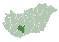 | |
| Villages |
| |
| Other topics |
| |
This article is issued from Wikipedia - version of the 10/21/2016. The text is available under the Creative Commons Attribution/Share Alike but additional terms may apply for the media files.