Asotin, Washington
| Asotin, Washington | |
|---|---|
| City | |
|
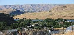
Asotin viewed from the elevated land to the south | |
 Location of Asotin, Washington | |
| Coordinates: 46°20′20″N 117°2′47″W / 46.33889°N 117.04639°WCoordinates: 46°20′20″N 117°2′47″W / 46.33889°N 117.04639°W | |
| Country | United States |
| State | Washington |
| County | Asotin |
| Area[1] | |
| • Total | 1.19 sq mi (3.08 km2) |
| • Land | 1.05 sq mi (2.72 km2) |
| • Water | 0.14 sq mi (0.36 km2) |
| Elevation | 801 ft (244 m) |
| Population (2010)[2] | |
| • Total | 1,251 |
| • Estimate (2015)[3] | 1,282 |
| • Density | 1,191.4/sq mi (460.0/km2) |
| Time zone | Pacific (PST) (UTC-8) |
| • Summer (DST) | PDT (UTC-7) |
| ZIP code | 99402 |
| Area code | 509 |
| FIPS code | 53-03075 |
| GNIS feature ID | 1503074[4] |
| Website | cityofasotin.org |
Asotin /əˈsoʊtən/ is the county seat of Asotin County, Washington, United States.[5] The population of the city was 1,251 at the 2010 census. It is part of the Lewiston, ID–WA Metropolitan Statistical Area.
History
The name Asotin is derived from a Nez Perce language term meaning "eel creek".[6] It was founded in 1878 by Alexander Sumpster. A river ferry stop at Asotin was set up by 1881.[6]
Geography
Asotin is located at 46°20′20″N 117°2′47″W / 46.33889°N 117.04639°W (46.338847, -117.046441).[7] The elevation is 801 feet (244 m) above sea level.
According to the United States Census Bureau, the city has a total area of 1.19 square miles (3.08 km2), of which, 1.05 square miles (2.72 km2) is land and 0.14 square miles (0.36 km2) is water.[1]
Climate
This region experiences warm (but not hot) and dry summers, with no average monthly temperatures above 71.6 °F. According to the Köppen Climate Classification system, Asotin has a warm-summer Mediterranean climate, abbreviated "Csb" on climate maps.[8]
Demographics
| Historical population | |||
|---|---|---|---|
| Census | Pop. | %± | |
| 1890 | 200 | — | |
| 1900 | 470 | 135.0% | |
| 1910 | 820 | 74.5% | |
| 1920 | 852 | 3.9% | |
| 1930 | 697 | −18.2% | |
| 1940 | 686 | −1.6% | |
| 1950 | 740 | 7.9% | |
| 1960 | 745 | 0.7% | |
| 1970 | 637 | −14.5% | |
| 1980 | 943 | 48.0% | |
| 1990 | 981 | 4.0% | |
| 2000 | 1,095 | 11.6% | |
| 2010 | 1,251 | 14.2% | |
| Est. 2015 | 1,282 | [9] | 2.5% |
| source:[10] 2015 Estimate[3] | |||
2010 census
As of the census[2] of 2010, there were 1,251 people, 500 households, and 352 families residing in the city. The population density was 1,191.4 inhabitants per square mile (460.0/km2). There were 537 housing units at an average density of 511.4 per square mile (197.5/km2). The racial makeup of the city was 93.5% White, 1.0% African American, 1.5% Native American, 0.6% Asian, 1.0% Pacific Islander, 0.2% from other races, and 2.2% from two or more races. Hispanic or Latino of any race were 2.2% of the population.
There were 500 households of which 33.0% had children under the age of 18 living with them, 51.6% were married couples living together, 13.2% had a female householder with no husband present, 5.6% had a male householder with no wife present, and 29.6% were non-families. 24.0% of all households were made up of individuals and 11.2% had someone living alone who was 65 years of age or older. The average household size was 2.50 and the average family size was 2.93.
The median age in the city was 41 years. 25.3% of residents were under the age of 18; 6.7% were between the ages of 18 and 24; 22.8% were from 25 to 44; 27.8% were from 45 to 64; and 17.6% were 65 years of age or older. The gender makeup of the city was 46.8% male and 53.2% female.
2000 census
As of the census of 2000, there were 1,095 people, 419 households, and 321 families residing in the city. The population density was 1,040.1 people per square mile (402.6/km²). There were 440 housing units at an average density of 418.0 per square mile (161.8/km²). The racial makeup of the city was 97.08% White, 0.18% African American, 1.00% Native American, 0.37% Asian, 0.18% from other races, and 1.19% from two or more races. Hispanic or Latino of any race were 1.55% of the population.
There were 419 households out of which 38.4% had children under the age of 18 living with them, 53.9% were married couples living together, 18.9% had a female householder with no husband present, and 23.2% were non-families. 19.3% of all households were made up of individuals and 9.1% had someone living alone who was 65 years of age or older. The average household size was 2.61 and the average family size was 2.96.
In the city the age distribution of the population shows 29.3% under the age of 18, 6.5% from 18 to 24, 25.4% from 25 to 44, 24.6% from 45 to 64, and 14.2% who were 65 years of age or older. The median age was 39 years. For every 100 females there were 88.8 males. For every 100 females age 18 and over, there were 81.3 males.
The median income for a household in the city was $35,083, and the median income for a family was $37,115. Males had a median income of $34,844 versus $21,063 for females. The per capita income for the city was $15,257. About 16.4% of families and 19.4% of the population were below the poverty line, including 30.2% of those under age 18 and 6.8% of those age 65 or over.
References
| Wikivoyage has a travel guide for Asotin. |
| Wikimedia Commons has media related to Asotin, Washington. |
- 1 2 "US Gazetteer files 2010". United States Census Bureau. Archived from the original on 2012-01-24. Retrieved 2012-12-19.
- 1 2 "American FactFinder". United States Census Bureau. Retrieved 2012-12-19.
- 1 2 "Population Estimates". United States Census Bureau. Retrieved July 1, 2016.
- ↑ "US Board on Geographic Names". United States Geological Survey. 2007-10-25. Retrieved 2008-01-31.
- ↑ "Find a County". National Association of Counties. Archived from the original on 2011-05-31. Retrieved 2011-06-07.
- 1 2 Majors, Harry M. (1975). Exploring Washington. Van Winkle Publishing Co. p. 142. ISBN 978-0-918664-00-6.
- ↑ "US Gazetteer files: 2010, 2000, and 1990". United States Census Bureau. 2011-02-12. Retrieved 2011-04-23.
- ↑ Climate Summary for Asotin, Washington
- ↑ "Annual Estimates of the Resident Population for Incorporated Places: April 1, 2010 to July 1, 2015". Retrieved July 2, 2016.
- ↑ Moffatt, Riley. Population History of Western U.S. Cities & Towns, 1850–1990. Lanham: Scarecrow, 1996, 313.
- ↑ United States Census Bureau. "Census of Population and Housing". Archived from the original on May 11, 2015. Retrieved October 5, 2013.
Municipalities and communities of Asotin County, Washington, United States | ||
|---|---|---|
| Cities |  | |
| CDPs | ||
| Unincorporated communities | ||
| Ghost towns | ||