Ashbourne Hills, Delaware
| Ashbourne Hills, Delaware | |
|---|---|
| Unincorporated community | |
 Ashbourne Hills  Ashbourne Hills | |
| Coordinates: 39°48′35″N 75°28′04″W / 39.80972°N 75.46778°WCoordinates: 39°48′35″N 75°28′04″W / 39.80972°N 75.46778°W | |
| Country | United States |
| State | Delaware |
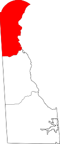
| County | New Castle |
| Elevation | 157 ft (48 m) |
| Time zone | Eastern (EST) (UTC-5) |
| • Summer (DST) | EDT (UTC-4) |
| Area code(s) | 302 |
| GNIS feature ID | 217485[1] |
Ashbourne Hills is an unincorporated community in New Castle County, Delaware, United States.[1] It is a suburban development of approximately 600 homes located on the western edge of Claymont, between Radnor Woods and Darley Road, on both sides of Naaman's Creek.[2]
References
- 1 2 "Ashbourne Hills". Geographic Names Information System. United States Geological Survey.
- ↑ "Plot and District Plan" (PDF). Ashbourne Hills Civic Association.
This article is issued from Wikipedia - version of the 7/31/2016. The text is available under the Creative Commons Attribution/Share Alike but additional terms may apply for the media files.