Asaminami-ku, Hiroshima
| Asaminami-ku, Hiroshima 広島市安佐南区 | |
|---|---|
| Ward of Hiroshima | |
| 安佐南区• Asaminami-ku | |
|
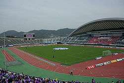
Hiroshima Big Arch | |
|
Location of Mihama in Asaminami-ku in Hiroshima City | |
 Asaminami-ku, Hiroshima
| |
| Coordinates: 34°27′07″N 132°28′19″E / 34.45194°N 132.47194°ECoordinates: 34°27′07″N 132°28′19″E / 34.45194°N 132.47194°E | |
| Country | Japan |
| Region | Chugoku (Sanyo) |
| Prefecture | Hiroshima |
| City | Hiroshima |
| Area | |
| • Total | 117.19 km2 (45.25 sq mi) |
| Population (February 29, 2012) | |
| • Total | 234,916 |
| • Density | 2,004.57/km2 (5,191.8/sq mi) |
| Time zone | Japan Standard Time (UTC+9) |
| Postal | 731-0193 |
| Asaminami Ward Office's Address | Furuichi 1-33-14, Asaminami-ku, Hiroshima City, Hiroshima Prefecture (広島県広島市安佐南区古市1丁目33番14号) |
| Phone | 81-(0)82-831-4925, 831-4927 |
Asaminami-ku (安佐南区) is one of the eight wards of the city of Hiroshima, located in the south of the former district of Asa.
Asa-gun consisted of Gion-cho, Yasufuruichi-cho, Sato-cho, Numata-cho. After being merged with Hiroshima in 1973, this ward was named Asaminami-ku. The largest station of Astramline Vehicles, a new traffic system, is in Asaminami-ku. This system brought population inflow because of increasing houses.
As of February 29, 2012, the ward has an estimated population of 234,916, with 96,925 households and a density of 2,004.57 persons per km². The total area is 117.19 km².
Transportation
JR-Kabe line
Astram line
- Gion-shinbashi-kita,
- Nishihara,
- Nakasuji,
- Furuichi,
- Ōmachi,
- Bishamondai,
- Yasuhigashi,
- Kamiyasu,
- Takatori,
- Chōrakuji,
- Tomo,
- Ōbara,
- Tomo-chūō,
- Ōzuka,
- Koiki-koen-mae
Highway
- San'yō Expressway
- Hiroshima IC (Interchange=exit)
- Numata PA
- Hiroshima JCT
- Hiroshima Expressway (NEXCO West)
- Hiroshimaseifushinto IC
- Hiroshima Expressway
- Numata IC
Industry
Hiroshima Mitsubishi Heavy Industries in Gion closed its doors in 2003.
Education
- Hiroshima City University
- Hiroshima University of Economics
- Hiroshima Shudo University
- Yasuda Women's University
Agriculture
They used to produce Hiroshimana-zuke in Satou-chou. It is said that Hiroshimana-zuke had produced since the Edo period.
Landslide
In August 2014 many people died in a landslide after very heavy rain.
| Wards of Hiroshima | |
|---|---|
| Core cities | |
| Cities | |
| Aki District | |
| Jinseki District | |
| Sera District | |
| Toyota District | |
| Yamagata District | |