Arthur River (Tasmania)
| Arthur | |
| River | |
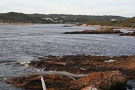 The mouth of the Arthur River | |
| Name origin: Sir George Arthur | |
| Country | Australia |
|---|---|
| State | Tasmania |
| Region | North-west |
| Tributaries | |
| - left | Keith River, Lyons River (Tasmania), Rapid River (Tasmania), Julius River, Frankland River (Tasmania) |
| - right | Waratah River, Wandle River (Tasmania), Hellyer River, Salmon River (Tasmania) |
| Source | Magnet Range |
| - location | south of Waratah |
| - elevation | 479 m (1,572 ft) |
| - coordinates | 41°29′43″S 145°25′30″E / 41.49528°S 145.42500°E |
| Mouth | Southern Ocean |
| - location | town of Arthur River |
| - elevation | 0 m (0 ft) |
| - coordinates | 41°03′22″S 144°39′21″E / 41.05611°S 144.65583°ECoordinates: 41°03′22″S 144°39′21″E / 41.05611°S 144.65583°E |
| Length | 172 km (107 mi) |
| National park | Savage River National Park |
| [1] | |

The Arthur River is a major perennial river located in the north-west region of Tasmania, Australia.
Location and features
The Arthur River rises on the slopes of the Magnet Range, south of Waratah and flows generally north and then west, around the northern perimeter of the Savage River National Park. The river is joined by 25 tributaries including the Waratah, Wandle, Hellyer, Keith, Lyons, Rapid, Julius, Salmon and Frankland rivers. The Arthur River reaches its mouth at the settlement of Arthur River where it empties into the Southern Ocean. The river descends 480 metres (1,570 ft) over its 172-kilometre (107 mi) course.[1]
The river was named in honour of Sir George Arthur, the Lieutenant Governor of Van Diemens Land between 1824 and 1836.
On the coast near the river mouth is a plaque titled The Edge of the World. North West Coast Tasmania, and a poem by tourism pioneer Brian Inder, who coined the term, referring to the coastline at Arthur River which is regularly lashed by the gales of the Roaring Forties.[2]
See also
References
- 1 2 "Map of Arthur River, TAS". Bonzle Digital Atlas of Australia. 2015. Retrieved 27 June 2016.
- ↑ "Cradle Coast Newsletter" (PDF). Tourism Newsletter. Cradle Coast. December 2005. Retrieved 8 October 2008.
River systems and rivers of Tasmania, Australia | |||||||
|---|---|---|---|---|---|---|---|
| |||||||
| |||||||
| |||||||
|