Arthur, Nebraska
| Arthur, Nebraska | |
|---|---|
| Village | |
|
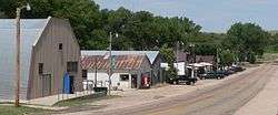
Downtown Arthur | |
 Location of Arthur, Nebraska | |
| Coordinates: 41°34′20″N 101°41′27″W / 41.57222°N 101.69083°WCoordinates: 41°34′20″N 101°41′27″W / 41.57222°N 101.69083°W | |
| Country | United States |
| State | Nebraska |
| County | Arthur |
| Area[1] | |
| • Total | 0.31 sq mi (0.80 km2) |
| • Land | 0.31 sq mi (0.80 km2) |
| • Water | 0 sq mi (0 km2) |
| Elevation | 3,655 ft (1,114 m) |
| Population (2010)[2] | |
| • Total | 117 |
| • Estimate (2012[3]) | 124 |
| • Density | 377.4/sq mi (145.7/km2) |
| Time zone | Mountain (MST) (UTC-7) |
| • Summer (DST) | MDT (UTC-6) |
| ZIP code | 69121 |
| Area code(s) | 308 |
| FIPS code | 31-02200[4] |
| GNIS feature ID | 0827062[5] |
Arthur is a village in, and the county seat of Arthur County, Nebraska, United States.[6] The population was 117 at the 2010 census.
History
Arthur was founded in 1914 as the planned seat of the newly formed Arthur County.[7] The town took its name from Arthur County, which was named for President Chester A. Arthur.[8] Arthur was incorporated as a village in 1944.[7]
Historic sites
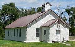
Two sites in Arthur are listed in the National Register of Historic Places. The Pilgrim Holiness Church was built in 1928 out of straw bales, in response to the region's dearth of trees or construction sod.[9] The First Arthur County Courthouse and Jail complex was built in 1914-15; the courthouse is billed as the smallest ever built in the United States.[10] Both sites are now maintained by the Arthur County Historical Society.
Geography
Arthur is located at 41°34′20″N 101°41′27″W / 41.572244°N 101.690738°W (41.572244, -101.690738),[11] in the Nebraska Sandhills.
According to the United States Census Bureau, the village has a total area of 0.31 square miles (0.80 km2), all of it land.[1]
Climate
According to the Köppen Climate Classification system, Arthur has a semi-arid climate, abbreviated "BSk" on climate maps.[12]
Demographics
| Historical population | |||
|---|---|---|---|
| Census | Pop. | %± | |
| 1950 | 176 | — | |
| 1960 | 165 | −6.2% | |
| 1970 | 175 | 6.1% | |
| 1980 | 124 | −29.1% | |
| 1990 | 128 | 3.2% | |
| 2000 | 145 | 13.3% | |
| 2010 | 117 | −19.3% | |
| Est. 2015 | 117 | [13] | 0.0% |
2010 census
As of the census[2] of 2010, there were 117 people, 61 households, and 35 families residing in the village. The population density was 377.4 inhabitants per square mile (145.7/km2). There were 82 housing units at an average density of 264.5 per square mile (102.1/km2). The racial makeup of the village was 99.1% White and 0.9% Asian.
There were 61 households of which 23.0% had children under the age of 18 living with them, 42.6% were married couples living together, 13.1% had a female householder with no husband present, 1.6% had a male householder with no wife present, and 42.6% were non-families. 42.6% of all households were made up of individuals and 23% had someone living alone who was 65 years of age or older. The average household size was 1.92 and the average family size was 2.60.
The median age in the village was 52.5 years. 20.5% of residents were under the age of 18; 3.4% were between the ages of 18 and 24; 13.7% were from 25 to 44; 34.2% were from 45 to 64; and 28.2% were 65 years of age or older. The gender makeup of the village was 51.3% male and 48.7% female.
2000 census
As of the census[4] of 2000, there were 145 people, 62 households, and 43 families residing in the village. The population density was 460.5 people per square mile (180.6/km2). There were 88 housing units at an average density of 279.5 per square mile (109.6/km2). The racial makeup of the village was 97.93% White, 0.69% Native American, 0.69% Asian, 0.69% from other races. Hispanic or Latino of any race were 2.07% of the population.
There were 62 households out of which 29.0% had children under the age of 18 living with them, 53.2% were married couples living together, 12.9% had a female householder with no husband present, and 30.6% were non-families. 27.4% of all households were made up of individuals and 16.1% had someone living alone who was 65 years of age or older. The average household size was 2.34 and the average family size was 2.84.
In the village the population was spread out with 25.5% under the age of 18, 2.8% from 18 to 24, 31.0% from 25 to 44, 23.4% from 45 to 64, and 17.2% who were 65 years of age or older. The median age was 41 years. For every 100 females there were 79.0 males. For every 100 females age 18 and over, there were 86.2 males.
The median income for a household in the village was $24,821, and the median income for a family was $31,458. Males had a median income of $25,417 versus $15,625 for females. The per capita income for the village was $15,196. There were 13.7% of families and 18.4% of the population living below the poverty line, including 20.8% of under eighteens and none of those over 64.
Transportation
The Arthur Municipal Airport is located about one mile (about a kilometer and a half) southwest of Arthur's central business district. The runways are unpaved. The airport handles about 25 operations per year.[15]
References
- 1 2 "US Gazetteer files 2010". United States Census Bureau. Archived from the original on 2012-01-24. Retrieved 2012-06-24.
- 1 2 "American FactFinder". United States Census Bureau. Retrieved 2012-06-24.
- ↑ "Population Estimates". United States Census Bureau. Archived from the original on 2013-06-17. Retrieved 2013-05-29.
- 1 2 "American FactFinder". United States Census Bureau. Archived from the original on 2013-09-11. Retrieved 2008-01-31.
- ↑ "US Board on Geographic Names". United States Geological Survey. 2007-10-25. Retrieved 2008-01-31.
- ↑ "Find a County". National Association of Counties. Archived from the original on 2011-05-31. Retrieved 2011-06-07.
- 1 2 "Arthur, Arthur County". Center for Advanced Land Management Information Technologies. University of Nebraska. Retrieved 29 July 2014.
- ↑ "Profile for Arthur, Nebraska". ePodunk. Retrieved 29 July 2014.
- ↑ Spencer, Janet Jeffries and D. Murphy (1979). "National Register of Historic Places Inventory–Nomination Form: Pilgrim Holiness Church" Nebraska State Historical Society. Retrieved 2010-08-10.
- ↑ Long, Barbara Beving. National Register of Historic Places Registration Form: First Arthur County Courthouse and Jail. Nebraska State Historical Society. Retrieved 2010-08-30.
- ↑ "US Gazetteer files: 2010, 2000, and 1990". United States Census Bureau. 2011-02-12. Retrieved 2011-04-23.
- ↑ Climate Summary for Arthur, Nebraska
- ↑ "Annual Estimates of the Resident Population for Incorporated Places: April 1, 2010 to July 1, 2015". Retrieved July 2, 2016.
- ↑ "Census of Population and Housing". Census.gov. Archived from the original on May 11, 2015. Retrieved June 4, 2015.
- ↑ "38V: Arthur Municipal Airport". Federal Aviation Administration (republished by AirNav). Effective 15 January 2009. Archived from the original on 4 March 2009. Check date values in:
|date=(help)
External links
Municipalities and communities of Arthur County, Nebraska, United States | ||
|---|---|---|
| Village | ||
| Unincorporated communities | ||