Arkansaw, Wisconsin
| Arkansaw | |
|---|---|
| Census-designated place | |
|
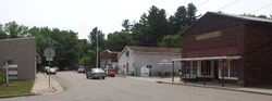
Downtown Arkansaw, Wisconsin | |
 Arkansaw Location within the state of Wisconsin | |
| Coordinates: 44°38′00″N 92°1′20″W / 44.63333°N 92.02222°WCoordinates: 44°38′00″N 92°1′20″W / 44.63333°N 92.02222°W | |
| Country | United States |
| State | Wisconsin |
| County | Pepin |
| Area[1] | |
| • Total | 0.720 sq mi (1.86 km2) |
| • Land | 0.712 sq mi (1.84 km2) |
| • Water | 0.008 sq mi (0.02 km2) |
| Elevation | 738 ft (225 m) |
| Population (2010)[2] | |
| • Total | 177 |
| Time zone | Central (CST) (UTC-6) |
| • Summer (DST) | CDT (UTC-5) |
| GNIS feature ID | 1560934[3] |
Arkansaw is an unincorporated census-designated place in the eastern portion of the town of Waterville, in Pepin County, Wisconsin, United States.[3] Located approximately 3 miles (4.8 km) west of Durand, it has the ZIP code of 54721.[4] As of the 2010 census, its population was 177.[2] From 1881 to 1886, the community was the county seat of Pepin County.[5]
History
Arkansaw was founded in the early 1850s at a crossing of Arkansaw Creek, a tributary of the Eau Galle River.[6] Initially built around lumbering, the first sawmill was opened in the community in 1852.[7]
The community was originally built near the center of three dams within a mile of each other on Arkansaw Creek. All three were wiped out in a flood in 1907. Arkansaw Creek was named in honor of the Arkansas River.[8] Today, the course of the creek runs through Arkansaw Creek Park.[9]
Geography
The community lies at the junction of U.S. Route 10 and Pepin County Trunk Highways D, N, O, and X. It has an area of 0.720 square miles (1.86 km2); 0.712 square miles (1.84 km2) of this is land, and 0.008 square miles (0.021 km2) is water.
Religion
The community is home to three churches: Catholic, Methodist and Community of Christ.
Notable people
- Lucius Roy Holbrook - U.S. Army Major General
- Willard Ames Holbrook - U.S. Army Major General
- Samuel L. Plummer - Wisconsin State Assemblyman
References
- ↑ "US Gazetteer files: 2010, 2000, and 1990". United States Census Bureau. 2011-02-12. Retrieved 2011-04-23.
- 1 2 "American FactFinder". United States Census Bureau. Archived from the original on 2013-09-11. Retrieved 2011-05-14.
- 1 2 "Arkansaw, Wisconsin". Geographic Names Information System. United States Geological Survey.
- ↑ Zip Code Lookup
- ↑ Pepin County History Archived May 13, 2006, at the Wayback Machine.
- ↑ http://www.uwec.edu/Library/archives/guides/upload/SCearly.pdf
- ↑ http://www.uwec.edu/Library/archives/guides/upload/Scearly.pdf
- ↑ Archived December 14, 2004, at the Wayback Machine.
- ↑ Archived July 19, 2008, at the Wayback Machine.
External links
Municipalities and communities of Pepin County, Wisconsin, United States | ||
|---|---|---|
| City | 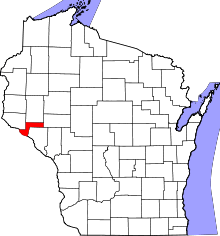 | |
| Villages | ||
| Towns | ||
| CDP | ||
| Unincorporated communities | ||
| Footnotes | ‡This populated place also has portions in an adjacent county or counties | |