Aqueduct of Padre Tembleque
 | |
| Official name | Sistema Hidráulico del Acueducto del Padre Tembleque |
|---|---|
| Begins | Zempoala, Hidalgo |
| Ends | Otumba, Mexico State |
| Coordinates | 19°50′04″N 98°39′45″W / 19.83444°N 98.66250°WCoordinates: 19°50′04″N 98°39′45″W / 19.83444°N 98.66250°W |
| Length | 45 kilometres (28 mi) |
| Conduit height | 38.75 metres (127.1 ft) Main Arcade |
| Construction began | 1553 |
| Opening date | 1570 |
| Type | Cultural |
| Criteria | i, ii, iv |
| Designated | 2015 (39th session) |
| Reference no. | 1463 |
| State Party | Mexico |
| Region | Latin America and the Caribbean |
The Aqueduct of Padre Tembleque, or Zempoala Aqueduct, is a Mexican aqueduct located between the towns of Zempoala, Hidalgo, and Otumba in the State of Mexico.
Site Description
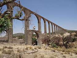
Originally constructed between 1553 and 1570, the aqueduct stretches 45 kilometres (28 mi) long, beginning at Tecajete volcano just east of Zempoala and terminating at Otumba.[1] It passed mostly at ground level, but also went underground as well as over ravines and valleys. There are three arcades along the aqueduct: the first has 46 arches, the second has 13, and the third has 67 arches. The highest valley the aqueduct spans is Papalote ravine, which is crossed by the 67 arch arcade also known as the Main Arcade, with the tallest arch standing 38.75 metres (127.1 ft).[1]
World Heritage Status
This site was added to the UNESCO World Heritage Tentative List on 20 November 2001 in the Cultural category.[1] It was inscribed on the World Heritage Site list on 5 July 2015.[2]
See also
| Wikimedia Commons has media related to Aqueduct of Padre Tembleque. |
- Acueducto del Padre Tembleque on the Spanish Wikipedia
- List of World Heritage Sites in Mexico
Notes
- 1 2 3 "Aqueduct of Padre Tembleque - UNESCO World Heritage Centre". Archived from the original on 15 April 2009. Retrieved 2009-03-02.
- ↑ "Sites in Japan, Turkey, Mexico, Uruguay inscribed on UNESCO's World Heritage List, extension of Spanish site approved". UNESCO. Retrieved 5 July 2015.
References
- Aqueduct of Padre Tembleque - UNESCO World Heritage Centre Accessed 2009-03-02.
- Kirby, R.S. & F.A. Davis (1990),Engineering in History, Courier Dover Publications. ISBN 0-486-26412-2
| North West |
| |
|---|---|---|
| North Central |
| |
| West |
| |
| East |
| |
| South West |
| |
| South Central |
| |
| South East |
| |
| ||