Oaxaca City
| Oaxaca | ||||||||
|---|---|---|---|---|---|---|---|---|
| City & Municipality | ||||||||
| Oaxaca de Juárez | ||||||||
| ||||||||
| ||||||||
|
Oaxaca Location in Mexico | ||||||||
| Coordinates: 17°04′04″N 96°43′12″W / 17.06778°N 96.72000°W | ||||||||
| Country | Mexico | |||||||
| State | Oaxaca | |||||||
| Founded | 1532 | |||||||
| Municipal Status | 1879 | |||||||
| Government | ||||||||
| • Municipal President |
Javier Villacaña Jiménez | |||||||
| Area | ||||||||
| • City | 85.48 km2 (33.00 sq mi) | |||||||
| Elevation of seat | 1,555 m (5,102 ft) | |||||||
| Population (2014) Municipality | ||||||||
| • City | 300,050 | |||||||
| • Metropolitan | 650,000 | |||||||
| Time zone | CST (UTC−6) | |||||||
| • Summer (DST) | CDT (UTC−7) | |||||||
| Postal code (of seat) | 68000 | |||||||
| Area code(s) | 951 | |||||||
| Website | (Spanish) /Official site | |||||||
| Official name | Historic Centre of Oaxaca and Archaeological Site of Monte Albán | |||||||
| Type | Cultural | |||||||
| Criteria | i, ii, iii, iv | |||||||
| Designated | 1987 (11th session) | |||||||
| Reference no. | 415 | |||||||
| State Party | Mexico | |||||||
| Region | Latin America and the Caribbean | |||||||


The city and municipality of Oaxaca de Juárez, or simply Oaxaca, is the capital and largest city of the Mexican state of the same name. It is located in the Centro District in the Central Valleys region of the state, on the foothills of the Sierra Madre at the base of the Cerro del Fortín extending to the banks of the Atoyac River.[1] This city relies heavily on tourism, which is based on its large number of colonial-era structures as well as the native Zapotec and Mixtec cultures and archeological sites.[1] It, along with the archeological site of Monte Albán, were named a World Heritage Site in 1987.[2] It is also the home of the month-long cultural festival called the "Guelaguetza", which features Oaxacan dance from the seven regions, music and a beauty pageant for indigenous women.[3]
It is nicknamed "la Verde Antequera" (the green Antequera) due to its prior name (Nueva Antequera) and the variety of structures built from a native green stone.[4] The name Oaxaca is derived from the Nahuatl name for the place, Huaxyacac, which was Hispanicized to Guajaca, later spelled Oaxaca. "de Juárez" was added in honor of Benito Juárez, who was a native of this state. The coat of arms for the municipality bears the image of the decapitated Donaji, who was an indigenous princess in the years immediately after the Conquest.[1]
History

There had been Zapotec and Mixtec settlements in valley of Oaxaca for thousands of years, especially in connection with the important ancient centers of Monte Albán and Mitla, which are close to modern Oaxaca city.[4] The Aztecs entered the valley in 1440 and named it "Huaxyacac," a Nahuatl phrase meaning "among the huaje" (Leucaena leucocephala) trees. A strategic military position was created here, at what is now called the Cerro (large hill) del Fortín to keep an eye on the Zapotec capital of Zaachila and secure the trade route between the Valley of Mexico, Tehuantepec and what is now Central America.[5] When the Spanish arrived in 1521, the Zapotecs and the Mixtecs were involved in one of their many wars. Spanish conquest would end this fighting.[6]
The first Spanish expedition here arrived late in 1521, headed by Captain Francisco de Orozco, and accompanied by 400 Aztecs.[5] Hernán Cortés sent Francisco de Orozco to Oaxaca because Moctezuma II said that the Aztec's gold came from there.[6] The Spanish expedition under Orozco set about building a Spanish city where the Aztec military post was at the base of the Cerro de Fortín. The first mass was said here by Chaplain Juan Díaz on the bank of the Atoyac River under a large huaje tree, where the Church of San Juan de Dios would be constructed later. This same chaplain added saints’ names to the surrounding villages in addition to keeping their Nahuatl names: Santa María Oaxaca, San Martín Mexicapan, San Juan Chapultepec, Santo Tomas Xochimilco, San Matías Jalatlaco, Santiago Tepeaca, etc. This group of Spaniards chose their first mayor, Gutierres de Badajoc, their first town council and began construction of the cathedral of Oaxaca in 1522. Their name for the settlement was Guajaca, a Hispanization of the Nahuatl name (which would later be respelled as Oaxaca).[5]
The establishment of the relatively independent village did not suit Hernán Cortes, who wanted power over the entire region for himself. Cortés sent Pedro de Alvarado, who proceeded to drive out most of the village's population. The original Spanish settlers appealed to the Spanish crown to recognize the village they founded, which it did in 1526, with land divided among the Spaniards of Orozco's expedition. However, this did not stop Cortés from driving out the population of the village once again and replacing the town council only three months after royal recognition. Once again, the original founders appealed to Spanish royal authority, this time to the viceroy in Mexico City, Nuño de Guzmán. This viceroy also sided with the original founders, and the town was refounded in 1529 as Antequera, in honor of Nuño de Guzmán's hometown. Francisco de Herrera convened the new, Crown-approved town council,[5] and the first layout of the settlement was mapped out by Juan Peláez de Berrio.[1]
In the meantime, Cortés was able to obtain from the crown the title of the Marquis of the Valley of Oaxaca, which contains the disputed village. This permitted him to tax the area heavily, and to have control of the territory that surrounded the village. The village was then in a position of having to survive surrounded by villages which answered to Cortés. These villages not only did not take orders from Antequera, they were hostile to it, mostly likely encouraged by Cortés.[5]
To counter this, the village petitioned the Crown to be elevated to the status of a city, which would give it certain rights, privileges and exceptions. It would also ensure that the settlement would remain under the direct control of the king, rather than of Cortés. This petition was granted in 1532 by Charles V of Spain.[1][5]
After the Independence of Mexico in 1821, the city became the seat of a municipality, and both the name of the city and the municipality became Oaxaca, changed from Antequera. In 1872, "de Juárez" was added to the city and municipality names to honor Benito Juárez, who began his legal and political career here.[1]
The 2006 Oaxaca protests began as a teachers’ protest, occupying the main square, or Zocalo, of Oaxaca city in May 2006. Increases in wages and employment benefits were announced a short time later, but an internal conflict in the local teachers’ union led to accusations that the bargaining had not really been in the teachers’ best interest. Work stoppage and occupation of the square continued from May 22 to June 1. At this point, radical groups joined in with the protest and the disorder grew, closing banks, access roads, the airport, access to stores and harassing the governor of the state in public appearances. Many of these groups merged with the teachers’ union to form the Popular Assembly of the People of Oaxaca (APPO). The disruption turned into a siege that lasted five months.[2] Violence included the deaths of a number of people including Indymedia journalist Bradley Roland Will on October 27, 2006[7] and Roberto López Hernández and Jorge Alberto Beltrán on October 29, 2006 when over 10,000 federal police and army intervened.[8][9] The situation calmed in the second week of November when the Federal Preventative Police took over the city and disbanded the protests.[2]
Climate
Oaxaca has a tropical savanna climate (Köppen climate classification Aw), closely bordering on a humid subtropical climate (Cwa), due to its high altitude. During the dry season, temperatures during the day remain warm with an average high of 27.1 °C (80.8 °F) in the coolest month, December, and an average high of 33.3 °C (91.9 °F) in April, just before the beginning of the wet season. Although daytime temperatures are warm, nighttime temperatures are cool with an average low of 9 °C (48 °F) in January . Due to its altitude of 1,555 metres (5,102 ft), the climate of Oaxaca is more mild than lowland areas with the same climate, resulting in cooler temperatures than lowland areas with the same climate. Precipitation is concentrated in the summer months with June being the wettest with an average precipitation of 171 mm (6.7 in).[10]
| Climate data for Oaxaca (1951–2010) | |||||||||||||
|---|---|---|---|---|---|---|---|---|---|---|---|---|---|
| Month | Jan | Feb | Mar | Apr | May | Jun | Jul | Aug | Sep | Oct | Nov | Dec | Year |
| Record high °C (°F) | 38.5 (101.3) |
38.0 (100.4) |
40.5 (104.9) |
41.6 (106.9) |
43.0 (109.4) |
40.0 (104) |
36.7 (98.1) |
36.5 (97.7) |
36.0 (96.8) |
35.5 (95.9) |
35.0 (95) |
34.0 (93.2) |
43.0 (109.4) |
| Average high °C (°F) | 27.6 (81.7) |
29.5 (85.1) |
31.9 (89.4) |
33.3 (91.9) |
32.5 (90.5) |
29.5 (85.1) |
28.5 (83.3) |
28.5 (83.3) |
27.8 (82) |
27.9 (82.2) |
27.7 (81.9) |
27.1 (80.8) |
29.3 (84.7) |
| Daily mean °C (°F) | 18.3 (64.9) |
19.9 (67.8) |
22.3 (72.1) |
24.0 (75.2) |
24.2 (75.6) |
22.8 (73) |
21.9 (71.4) |
21.8 (71.2) |
21.5 (70.7) |
20.8 (69.4) |
19.4 (66.9) |
18.3 (64.9) |
21.3 (70.3) |
| Average low °C (°F) | 9.0 (48.2) |
10.3 (50.5) |
12.7 (54.9) |
14.8 (58.6) |
15.9 (60.6) |
16.1 (61) |
15.2 (59.4) |
15.1 (59.2) |
15.3 (59.5) |
13.7 (56.7) |
11.1 (52) |
9.6 (49.3) |
13.2 (55.8) |
| Record low °C (°F) | 0.5 (32.9) |
1.0 (33.8) |
3.0 (37.4) |
4.0 (39.2) |
9.0 (48.2) |
9.0 (48.2) |
9.0 (48.2) |
9.0 (48.2) |
9.0 (48.2) |
4.5 (40.1) |
1.0 (33.8) |
0.0 (32) |
0.0 (32) |
| Average precipitation mm (inches) | 3.6 (0.142) |
5.4 (0.213) |
13.1 (0.516) |
39.7 (1.563) |
85.4 (3.362) |
171.0 (6.732) |
116.3 (4.579) |
114.5 (4.508) |
138.1 (5.437) |
51.4 (2.024) |
9.0 (0.354) |
3.2 (0.126) |
750.7 (29.555) |
| Average precipitation days (≥ 0.1 mm) | 1.0 | 1.3 | 2.3 | 5.7 | 10.5 | 17.2 | 16.9 | 16.5 | 17.2 | 7.6 | 2.3 | 0.9 | 99.4 |
| Average relative humidity (%) | 58 | 58 | 54 | 55 | 60 | 66 | 69 | 69 | 74 | 70 | 66 | 63 | 64 |
| Mean monthly sunshine hours | 282 | 260 | 295 | 285 | 264 | 184 | 202 | 178 | 162 | 245 | 267 | 267 | 2,891 |
| Source #1: Servicio Meteorológico Nacional (humidity 1981–2000)[10][11][12] | |||||||||||||
| Source #2: Deutscher Wetterdienst (sun, 1961–1990)[13][lower-alpha 1] | |||||||||||||
Economy and tourism
The events of 2006 had a severe impact on the city's main generator of revenue: tourism.[2] The city is the primary attraction of the state, which also relies economically on tourism. Over the last 25 years, tourism has grown to become the dominant factor of Oaxaca's economy.[14] 77% of the municipality of Oaxaca has employment that is related in some way to tourism. The attractions are the verdant landscapes of the Oaxaca Valley, and the architectural and cultural charms of the city itself.[14] The next largest economic sectors are mining and manufacturing, which employ 20% of the work force.[1]
The city centre was included in a World Heritage Site designated by UNESCO, in recognition of its treasure of historic buildings and monuments.[15] Tourist activity peaks in three seasons: Holy Week, summer (especially during Guelaguetza) and New Year. Many of the tourists who come during Holy Week and for New Year come from other parts of Mexico and include native Oaxacans returning to visit from their places of work. Most international visitors come during the summer.[2]
Notable sites
Plaza de la Constitución or Zócalo

The Plaza de la Constitución, or Zócalo, was planned out in 1529 by Juan Peláez de Berrio. During the entire colonial period this plaza was never paved, nor had sidewalks, only a marble fountain that was placed here in 1739. This was removed in 1857 to put in the kiosk and trees were planted. In 1881, the vegetation here was rearranged and in 1885, a statue of Benito Juárez was added. It was remodeled again in 1901 and a new Art Nouveau kiosk installed. Fountains of green stone with capricious figures were installed in 1967.[1] The kiosk in the center hosts the State Musical Band, La Marimba and other groups.[16]
The plaza is surrounded by various portals. On the south side of the plaza are the Portales de Ex-Palacio de Gobierno, which was vacated by the government in 2005 and then reopened as a museum called "Museo del Palacio 'Espacio de Diversidad'" Other portals include the "Portal de Mercadores" on the eastern side, "Portal de Claverias" on the north side and the "Portal del Señor" on the west side.[4]
The State Government Palace is located on the main square of Oaxaca City. This site used to be the Portal de la Alhóndiga (warehouse) and in front of the palace is the Benito Juárez Market. The original palace was inaugurated in 1728, on the wedding day of the prince and princess of Spain and Portugal. The architectural style was Gothic. The building currently on this site was begun in 1832, inaugurated in 1870 but was not completed until 1887. The inside contains murals reflecting Oaxaca's history from the pre-Hispanic era, the colonial era and post-Independence. Most of these were painted by Arturo Garcia Bustos in the 1980s.[1]
The Federal Palace is located across from the Cathedral and used to be the site of the old Archbishiop's Palace until 1902. Its architecture is "neo-Mixtec" reflecting the nationalism of the early 20th century and the reverence in which the Mixtec-Zapotec culture has been held in more recent times. The architectural elements copy a number of those from Mitla and Monte Albán.[1]
Northwest of the Zócalo is the Alameda de León, a garden area[4] that is essentially an annex of the main square. In 1576, viceroy Martín Enréquez de Almanza set aside two city blocks on which to build the city government offices, but they were never built here. One of the blocks was sold and the other became a market. Antonio de León, governor of the state of Oaxaca, lived in front of this market and decided to turn it into a park in the 1840s, making it a small replica of the Alameda Central in Mexico City. In 1885, a statue of León was added.[1]

Andador Macedonio Alcalá
The Macedonio Alcalá Tourist Corridor is a street paved with green cantera that was closed to traffic in 1985[16] and is now only open to pedestrian traffic. Along the street are notable places such as the original building to house the Universidad Autónoma Benito Juárez. The Museo de Arte Contemporáneo (Museum of Contemporary Art) or MACO is located here as is the Plazuela (small plaza) Labastida and the Parroquia de la Preciosa Sangre de Cristo (Parish of the Precious Blood of Christ).[4]
Churches and religious buildings

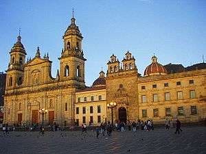
The Catedral de Oaxaca, also referred to as Cathedral of Our Lady of the Assumption, is the third to be built as the first two were destroyed by large earthquakes in the 16th and 18th centuries.[4] Construction of this third church began in 1702 and it was consecrated in 1733. Its facade is made of the green cantera stone commonly found in Oaxaca's buildings, and the interior is in Neoclassical style. The altar features a statue of Our Lady of the Assumption (Nuestra Señora de al Asunción) which was made in Italy during the Porfirio era,[4] who is represented by a bronze sculpture brought from Europe and made by Tadoini.[17]

The church and former monastery of Santo Domingo de Guzmán is located 4 blocks north of the Cathedral of Oaxaca. It was constructed between 1555 and 1666. It divides into two parts: the church and the former living/working areas of the monks. The front of the church is Renaissance-style, in the central relief, Saint Dominic and Hippolytus of Rome are holding up the church. After La Reforma around 1860, the church was converted into a stable, which caused serious deterioration of the building. It was returned to devotional use at the end of the 19th century. The living and working areas were converted into barracks and officers´ quarters. In 1994, work began to convert this area as the Centro Cultural Santo Domingo.[4]

The Basílica de Nuestra Señora de la Soledad is located four blocks west of the Cathedral on Avenida Independencia. It is built between 1682 and 1697 by Father Fernando Méndez[17] on a site where supposedly an image of the Virgin Mary appeared inside a box. It is of Baroque style finished in 1690. Its front is made of a reddish stone sculpted to look like a folding screen. In the back of the church is the Museo de la Basilica de Nuestra Señora de La Soledad that exhibits the Virgin's dresses, offering and small painting done in her honor.[4] The statue of the Virgin of Solitude, crowned with a 2 kg solid gold crown studded with diamonds – was the subject of a theft recently. Many years later, the cloister was converted into a correctional facility, a teacher's college and district attorney's office. Now it serves as the Municipal Palace. The building conserves a number of valuable items such as paintings, sculptures and religious vestments[17] and a pipe organ dated 1686.[18]
The Church and ex-monastery of Del Carmen Alto belonged to the Carmelites who established themselves here in 1696. The complex began as a hermitage built over the teocalli of Huaxyacac, although in the late 17th century, much of this space was occupied by a jail and barracks. The project was financed by Manuel Fernandez Fiallo.[17]
Church and former monastery of St John of God (Templo y Exconvento de San Juan de Dios), Oaxaca's oldest church still standing, completed in 1703. This is where the first mass in Oaxaca was held in 1521.[1]

Church of San Felipe Neri The Church of San Felipe Neri is considered a classic example of Baroque with estipite (inverted truncated pyramid) columns from the end of the 18th century, and has a large gilded main altarpiece. While the church overall is Baroque, the portal contains other decorative elements as well. Benito Juárez married Margarita Maza here in 1841.[17]
Ex monastery of San Catalina was built in the second half of the 16th century by Dominican monk Hernando de Carvarcos, who also was responsible for the Santo Domingo de Guzmán monastery. In 1862, the monastery became a jail and at the end of the 19th century, the southern part became the Municipal Palace. Since 1976, it has been a hotel, called Hotel Camino Real.[16]
Church of the Company of Jesus (Iglesia de la Compañia de Jesús), located to the southwest of the Zócalo, was built by the Jesuits in 1579 and consecrated to Francis Xavier and the Immaculate Conception.[17] The towers were destroyed by a series of earthquakes and never rebuilt. Inside the chapel is a statue of the Virgin of Guadalupe with a prayer written in Spanish, English, Náhuatl as well as 12 other languages native to the state of Oaxaca, including 4 dialects of Zapotec.[4]
Museums and the arts

The Centro Cultural de Santo Domingo occupies the former monastery buildings attached to Santo Domingo church, and were restored in 1996 and considered to be one of the best restoration works in Latin America.[19] Some important artifacts from Monte Albán are displayed here. In the center of the Centro Cultural, there is a courtyard with a fountain and a very large staircase. The passages along the courtyard have vaulted ceilings, cupolas and intricate corridors. Much of the Centro Cultural is occupied by the Museo de las Culturas de Oaxaca (Museum of Oaxacan Cultures), whose entrance is the one pilgrims used to use to enter the church area of the complex.[4] This museum was placed in the Centro Cultural in 1964, after originally being in the Instituto de Ciencias y Artes, among other places. The museum specializes in Zapotec and Mixtec cultures, covering ten halls and one auditorium.[1] In Sala III is displayed the "Tesoro Mixteco"(Mixtec Treasure) which is a collection of offerings that were discovered by archeologist Alfonso Caso in Tomb 7 of Monte Álban. These offerings include hundreds of pieces of jewelry made of gold and silver. They make up the richest collection of gold and silver smithing of ancient Mexico.[4] Another important exhibit is the objects from Tomb 5 of Lambitieco, which dates back to 700 C. E and from Monte Albán. The museum has rooms dedicated to everyday items from the colonial period as well.[1] The center also contains the Biblioteca Fray Francisco de Burgoa (Fray Francisco de Burgoa Library) which holds over 25,000 degrees that were conferred from the 15th to the 20th century from the Universidad Autónoma Benito Juárez in Oaxaca.[4]
The Museum of Contemporary Art (Museo de Arte Contemporaneo de Oaxaca, MACO) is housed in the so-called Casa de Cortés. It is one of the oldest buildings in the city and one of the most representative of non-religious buildings.[1] However, since it dates from after the death of Hernán Cortés, it could never actually have served as his house.[4] Although it has been modified somewhat over the years, it still conserves its basic layout with rooms surrounding three courtyards. The architectural style is basically Andalucian modified by Oaxaca traditions. The facade has two levels, and the doors and windows have lintels, and are protected by wrought iron railings. To the far left of the facade, there are two arched entrances that permitted entrance of carriages to the third courtyard. The main portal is Spanish Baroque and has three levels. In the first, there are two "tritóstila" columns that support the balcony which has wrought iron railings. On the second level two Solomonic columns flanking a window. The jambs of the window are decorated with circles and the lintel with inverted curves. At the top of the window is seal of the Jesuits. The third level contains a central niche with a sculpture of an archangel as well as the coats of arms of the Laso de la Vega and the Pinelo families. This group is flanked by Solomonic columns. The house was acquired by the state of Oaxaca and initially housed the Museo Historico Urbano de Oaxaca in 1986.[1] The museum was created with help from the state government, the José F. Gómez Foundation, painter Francisco Toledo and the Instituto Nacional de Bellas Artes. It permanent collection contains works by Rufino Tamayo, Toledo, Nieto, Aquinos and others.[19]
The Museo de los Pintores Oaxaqueños(Museum of Oaxacan Painters) is located north of the Alameda de León on Avenida Independencia in a former 18th century mansion. It is dedicated to local artists such as Rodolfo Morales whose work is on permanent display. The museum has also featured exhibitions by Felipe Morales, Rodolfo Nieto, Alejandro Santiago and Francisco Toledo.[4]
The Casa de Culturas Oaxaqueñas used to the Church and ex monastery Los Siete Príncipes dating from the 18th century. The only part still used for religious purposes is the small chapel. The complex was restored in the 1960s and in 1970, the Casa opened.[17] It houses the Instituto Oaxaqueño de la Culturas, which is a state government entity to promote culture and the arts.[16]
The Rufino Tamayo Museum (Museo Arte Prehispánico de Rufino Tamayo) or Museo Rufino Tamayo, has an important collection of pre-Hispanic art that the painter himself collected. He donated the collection, as well as the house that is now the museum to his home state (Oaxaca) in 1974.[4] This house, which was known as the Casa de Villanaza, was built in the 18th century. It first housed the State Museum Archives, before becoming what it is today.[19] The museum exhibits over 1150 pieces from different Mesoamerican periods, including Mayan steles, ceramic dogs from Colima and stone faces from the Gulf of Mexico coast. The purpose of the museum is to show the aesthetic as well as the cultural value of these works.[4]
The Religious Museum of the Ex monastery of La Soledad is located next to the Basilica of la Soledad. It contains objects such as paintings, sculptures and vestments. It is located in the southwest portion of the old monastery.[16]
The Instituto de Artes Gráficos de Oaxaca (Graphic Arts Institute of Oaxaca) contains a large collection of graphic designs both present and past.[19]
The Casa de Juárez, is a museum devoted to the life of Benito Juárez.[1] It belonged to someone named Antonio Salanueva,[19] but Juárez lived here from 1818 to 1828 after arriving to Oaxaca city from his hometown of Guelatao.[1] It contains documents related to his presidency as well as furnishings designed to recreate the environment of that period. Its architecture is typical of homes built in this city in the 18th century and located on Garcia Vigil 609.[4] It also contains ordinary artifacts from that time period, some of which belonged to Juárez.[19]
Hemeroteca Publica de Oaxaca "Nestor Sánchez" (Nestor Sanchez Public Newspaper Library of Oaxaca) is located behind the ex-convent of Santo Domingo along with the Jardin Ethobotánico (Ethnobotanic Gardin) at the corner of Reforma and Constitución. These two occupy more than 2 hectares which used to be the gardens of the convent of Santa Domingo.[4]

Teatro Macedonio Alcalá, which as well as being a working theatre houses a collection of romantic art.[4] The Macedonio Alcalá Theater is a work typical for Porfirio Díaz period at the end of the 19th century and the beginning of the 20th. It was first named the Luis Mier y Terán Theater, then Jesús Carranza. The current name dates back to 1932 to honor the composer of the state anthem "Dios Nunca Muere" (God Never Dies).[16] The Macedonio Acalá Theatre is named after the author of the state anthem and was built between 1903 and 1909. The theatre has three parts, the vestibule, the main hall and the stage. The main entrance is on the corner. On the Armenta and Lopez Street sides, the lower level is occupied by shops, as well as the Miguel Cabrera Salon, which hosts art exhibits. The vestibule is Louis XV style with a white marble staircase and the main hall is in "Imperial" style, in which the anthropomorphic columns stand out.[1]
Other cultural places of interest include the Alvarez Bravo Photography Center, the Oaxaca Stamp Museum, the Railway Museum of Southern Mexico (in the old train station) and the Planetarium located on the Cerro del Fortín.[4]
Monte Albán

Monte Albán is a pre-Hispanic city that was an ancient capital of the Zapotecs. It reached its peak between 500 BCE and 800 CE with about 35,000 inhabitants. Monte Albán is known for its architecture, its carved stones and the ceramic urns. In 1987, it was declared a World Heritage Site, along with the city of Oaxaca itself.[20]
Markets

The Mercado (Market) Benito Juárez is located one block south of the Zócalo on Flores Magón and Las Casas but it takes up the entire block to 20 de Noviembre and Aldama streets. It offers flowers, fruit, ices, fruit drinks, handcrafts, leather goods, hats and knives, among other things.[4] The Mercado (Market) 20 de Noviembre is the official name, but this market is commonly known as the "Mercado de la Comida (food)" because of the food stands that dominate the place. It is recommended by México Desconocido magazine for Oaxacan regional dishes such as moles, tasajo, tlayudas, pan de yema (a type of egg bread), chapulines (fried grasshoppers in chile), Oaxaca cheese (known locally as "quesillo"), queso fresco (lit. "fresh cheese"), as well as very large cups of hot chocolate made locally that is often spiced with cinnamon and almonds.[4]
Parks and gardens

The city contains a number of parks, gardens and plazas, many of which were former monastery lands, for example, the Jardín Etnobotánico de Oaxaca, surrounding the former monastery of Santo Domingo.[4] Even better known is the Plaza de la Danza y Jardín Sócrates complex on Morelos Street at the foot of the Cerro del Fortín. It is part of the area bounded by the Basilica de la Soledad and the Church of San José. The Plaza de la Danza was constructed in 1959 by Eduardo Vasconcelos to hold the annual Bani-Stui-Gulal (representation of antiquity) dance, held one day before the festival of the Guelaguetza. The Plaza also hosts other cultural events including art shows, concerts and political rallies The Socrates Garden is the old atrium of the Basilica de la Soledad converted into a public park in 1881, conserved the bronze chalice which was also made in 1881. In 1981, the Garden was remodeled adding a new layer of stone to the floor.[1] The Cerro de Fortín next to it bears in stone letters Benito Juárez's slogan, "El respeto al derecho ajeno es la paz" (Respect for others' rights is peace).[4] The Antonia Labastida Garden is named alter a woman who fought with Porfirio Díaz during the French Intervention. This park has become a place for artists and artisans to display their wares.[16]
Festivals and traditions
Guelaguetza

The Guelaguetza, also known as the Fiestas de los Lunes del Cerro (Festivals of Mondays at the Hill) is the major cultural event in the city with origins in pre-Hispanic times. The "Hill" is the Cerro del Fortín, which was the scene of the annual rites to the goddess Centeótl, or goddess of the corn. The hill had a teocalli, or sacred plaza, built by the Aztecs. The ritual would end with the sacrifice of a young maiden chosen to represent the goddess.[3]
This rite was prohibited by the Spanish after the Conquest, who also destroyed the teocalli. In its place, they constructed the Church of Our Lady of Mount Carmen, now known as Carmen Alto. The recently baptized Mixtecs and Zapotecs then replaced ceremonies to Centeótl with those to this manifestation of the Virgin Mary, at the same place, the Cerro del Fortín.[3]
This revised festival grew over time to be the largest and most anticipated for the town. In 1932, the city of Oaxaca realized its 400th anniversary and decided to combine these festivities with those of the Cerro del Fortín, adding traditional dances, music, regional cuisine and Margarita Santaella as the first Miss Oaxaca, in addition to the religious rites. The word "guelaguetza" is from Zapotec and means offering, sympathy, caring and cooperation. This first Guelaguetza was such a hit that organizers decided to repeat it every year at the Cerro del Fortin, on all the Mondays of July starting in 1953, becoming an amalgam of Oaxacan festivals from many parts of the state.[3]
Originally, the festival took place at the foot of the Cerro del Fortín, where the curve of the land makes for a natural theatre. Since 1974, many of the events, which have grown in number, have been moved to a number of different venues, included the then-inaugurated Guelaguetza Auditorium. This is a Greek-style venue with seats 11,400 people.[3]
One venue is the Church of Santo Domingo de Guzmán, where regional band come to play, dressed in colorful costumes as part of the opening ceremonies. They march from here to the Oaxaca Cathedral, where they are joined by folk dance groups such as the China Oaxaqueñas, the Chilenas de Pinotepa Nacional and the Jarabes Serranos. Another major event, which takes place at the Jardin Socrates, is a beauty pageant for indigenous women from different regions of Oaxaca state. The winner represents the goddess Centeótl and presides over the festivities along with public officials. The Bamo-Stui-Gulal takes place at the Plaza de la Danza and represents the history of Oaxaca and the Guelaguetza itself. The Plaza is divided into four quadrants, each representing a different period in Oaxaca's history. One other event, hosted in the Auditorium is a reenactment of the Legend of Donají, which takes place at the time of the Conquest. On the streets of Oaxaca city, there are parades with children and giant paper mache puppets.[3]
Noche de Rábanos
The "Noche de Rábano" or Night of the Radishes is a traditional Oaxaca city tradition. Artisans show off designs done on large radishes, often decorated with other plant materials. The event only lasts a few hours but draws most of the city's population to the main square to look at the creations. It occurs each year on 23 December.[21]
The event developed from a Dominican Christmas tradition, when they would have a large dinner on the night of 23 December. To decorate the tables, indigenous servants of the monks would carve radishes and adorn them with flowers and other plants. This led 23 December to the known as the Night of the Radishes. This led to a special market on this day selling the radishes along with two other popular Christmas plant materials, the Flor Inmortal (immortal flower) and corn husks. This market has grown into a major cultural event and now is sponsored by the city, which packs the main square on that day. The day also includes a competition where radish creations are judged by originality, technical skill and beauty.[21]
Donají
The story of Donají is that of a princess from pre-Hispanic Mitla. When she was born, a seer predicted that she would die for her country. When she grew up, her people, the Zapotecs, were involved in one of their many wars with the Mixtecs. One day, Zapotec warriors brought a prisoner, a Mixtec prince named Nucano, to Mitla. Taking pity on him, she took care of his wounds. When he healed, he asked her to let him go, which she did. The war continued with the Zapotec king and Donaji forced to abandon their capital of Zaachila. Peace negotiations were attempted but the Mixtecs did not trust the Zapotec king, taking Donají captive as insurance. This occurred during the Conquest, when the evangelization of the country had begun. Donají asked for baptism and was renamed Doña Juana de Cortés.[22]
As feared, the Zapotecs broke the peace treaty, attacking Monte Albán as the Mixtecs slept. Donají was found in the Atoyac River, decapitated. Time passed. One day a Shepherd came to the place that Donaji was buried by the river. There was a fragrant lily flower growing. Fifteen days later, he returned to find the same flower, still fresh and fragrant in the same place as if a mysterious force was preserving it.[22] Her severed head serves as part of the coat of arms of the city of Oaxaca[1] and her story is reenacted every year at the Guelaguetza festival.[3]
Cinema
Every year in the fall, Oaxaca hosts the Oaxaca Film Fest.
Food and drink


The city of Oaxaca has long been considered "Mexico's culinary capital."[23] The most notable aspect of Oaxacan cuisine is its variety of moles, a type of complex sauce. Their origins go back to the melding of Spanish and Arabic food in Spain. After the Conquest, New World ingredients such as chile mulato, 'miltomate' (a small whitish wild tomato), tomatoes, peanuts, avocado leaves, and chocolate were incorporated. While moles can be found in many parts of Mexico, Oaxaca has the greatest variety including negro (black), Colorado (red), coloradito (faint red), chichilo, verde (green), amarillo (yellow), and mancha manteles (lit. 'stainer of tablecloths'). They are sold in markets all over the city as a paste which is combined with water and simmered with a variety of meats.[24]
Other notable foods sold in markets include bars of chocolate (primarily used for making hot chocolate), traditional breads, and chapulines (fried grasshoppers with chile). Street foods include tlayudas, which are large, slightly crispy corn tortillas piled high with ingredients such as grilled beef (called tasajo), cheese, tomatoes, avocados, onions etc. Local drinks include those made with water, sugar and a flavoring such as aguamiel (honey water), trocitos de melón (melon), horchata (rice), tuna batida (cactus fruit shake), and nuez (nuts) as well as local fruits such as chilacayota and guanábana. In nearby Tlacolula and Ejutla an indigenous drink called 'tejate' is still prepared and sold in the local market. Known here as the drink of the gods, it is prepared with corn, cacao, cacao flower and the seed of the mamey fruit. As for alcoholic beverages, this area prefers mezcal, which, like tequila is made from a species of agave but the flavor is very different.[24]
As in other areas in Mexico, chocolate has had special importance here since long before the Conquest. Aside from being a foodstuff, it was also used as medicine and cacao seeds were used as money. The chocolate prepared in this city is well-known within Mexico, as it is distinguished by being flavored with cinnamon, almonds and sugar and is usually prepared with hot water or milk. It is usually served in large coffee cups with a local sweet roll. The best-known producer of this type of chocolate is Chocolate El Mayordomo, which recently has opened outlets in various parts of Mexico, esp. in Mexico City. In their main store in Oaxaca City, you can see them prepare the various types of chocolates they prepare including a chocolate pasta.[24]
Notable Oaxacans
- Benito Juárez
- Porfirio Díaz
- José Vasconcelos
- Ricardo Flores Magón
- Rodolfo Morales, artist
- Rufino Tamayo, artist
- Francisco Toledo, artist
- Lila Downs, singer
- Vinny Castilla, Major League Baseball player
- Gerónimo Gil, Major League Baseball player
- Macedonio Alcalá composer
- Nadia Yvonne Lopez Ayuso, singer
- Maria Sabina, shaman
- Carlos María de Bustamante, statesman
- Ritchie Ortiz Juárez, Actor
Education

In terms of institutions of higher education Oaxaca has several universities. Oaxaca is the site of the Universidad Autónoma Benito Juárez de Oaxaca, which has buildings in various parts of the city. The most visible building is the Edificio Central de la Universidad (Central Building of the University), which is located in the historic downtown. It is in a building that originally housed the Sciences Institute. It was constructed between 1899 and 1901, in the European Romantic style that was popular for academic institutions at that time. However, indigenous touches, such as the cresting over the portal, can be seen as well. This building houses the Department of Law and Social Studies as well as the gymnasium.[1] Additionally, the Universidad de Mesoamérica has locations in the city. The Universidad Anáhuac Oaxaca was opened in 2000.
Transportation
Oaxaca-Xoxocotlan airport (IATA code OAX) is approximately 7 km south of the city centre. Most flights are to Mexico City for onward connection, but there are also flights to Huatulco, Cancún, Tuxtla Gutierrez and Tijuana. United Airlines has flights between Oaxaca and Houston.
The city has separate first class and second class bus stations, offering services to most places within the state of Oaxaca, including the coastal resorts of Huatulco, Puerto Escondido, Puerto Ángel and Pinotepa Nacional, and also long-distance services to Puebla and Mexico City and other Mexican locations such as Veracruz. There are several bus lines which run in Oaxaca. The largest is TUSUG, a type of "cooperative" company. All of the drivers own their own buses and are aided by other drivers in purchasing new buses.
The major highways serving Oaxaca are Federal Highways 175 and 131, southwards to the Oaxacan coastal resorts; National Highways 190 and 125, southwest to Pinotepa Nacional; National Highways 190 and 130, to Mexico City; the autopista 150D/131D, offering a more rapid route to Mexico City; and National Highway 175 north to Veracruz, Veracruz.
Surrounding towns
A number of small towns surround the main city and are closely linked economically and culturally with the main city. Some of these towns are known for producing certain crafts that are identified with the three central valleys of Oaxaca. In these towns one can see the workshops and the crafts being produced in the traditional manner although most of these towns' products are sold in the main city. Santa María Atzompa produces glazed, glass-inlaid pottery of green, while San Antonio Arrazola and San Martín Tilcajete make alebrijes, small painted wooden figures. San Bartolo Coyotepec is known for its barro negro pottery, and Teotitlán del Valle works with wool and llama to make tapetes, or more commonly, throw rugs. These rugs are known for their intense colors, made traditionally with natural dyes, made from cempasúchil (yellow), cochineal (red) and indigo (blue). In addition, Oaxaca city and surrounding towns have market days, where one can visit the tianguis (open-air markets) set up for that day. There are markets on each day of the week. Monday in Miahuatlan is for buying daily staples, and Tuesday, in Ayoquezco is noted for wood furniture. On Wednesday, people head to Etla and Zimatlán for dairy products, especially cheese. Thursday is reserved for the two largest tianguis in Ejutla and Villa de Zaachila. On Friday, in Coyotepec, Jalietza and Ocotlán cotton textiles, embroidered blouses, corn-husk flowers and glazed pottery from Atzompa are sold. Also Llano park in Oaxaca has a small market. Saturday is reserved for the main city of Oaxaca, and to finish, on Sunday mezcal is sold in Tlacolula.[4]
Municipality of Oaxaca
As municipal seat, Oaxaca city has governmental jurisdiction over the following communities: Arbolada Ilusión, Camino a San Luis Beltrán, Camino Ancho, Casas del Sol, Colonia Buena Vista, El Bajío (Rancho Guadalupe Victoria), El Silencio, Entrada de el Silencio, Gloria Antonio Cruz, Guadalupe Victoria, Guadalupe Victoria Segunda Sección (La Mina), Lachigulera, Las Salinas (El Arco Grande), Loma Bonita, Lomas Panorámicas, Los Ángeles, Los Ángeles Uno, Miravalle, Paraje Caballetiyo, Paraje el Cerrito, Paraje el Pando, Paraje la Canoa, Paraje la Loma, Paraje la Mina, Paraje la Rabonera, Paraje Pio V (Ojito de Agua), Paraje Tierra Colorada, Pueblo Nuevo Parte Alta, Rancho el Chilar, Rancho los Girasoles, San Bernardo, Solidaridad, and Viguera The municipality has a total area of 85.48 km2[1] and a population of 265,006, 97% percent of which lives in the city of Oaxaca[25] While much of the indigenous population disappeared during the colonial era, sixteen different ethnic groups continue to inhabit the municipality. Spanish is the most commonly used tongue[14] but during the 2005 census, there were 20,109 people who spoke an indigenous language, between seven and eight percent of the population.[1]
The municipality is bordered by San Pablo Etla, San Antonio de la Cal, Santa Cruz Xoxocotlán, San Andrés Huayapam, San Agustín Yatareni, Santa Lucía del Camino, Santa María Atzompa and San Jacinto Amilpas.[1] It is located in the Valley of Oaxaca in the Sierra Madre del Sur Mountains, at 17°05′N 96°45′W / 17.083°N 96.750°WCoordinates: 17°05′N 96°45′W / 17.083°N 96.750°W near the geographic center of the state, and at an altitude of about 1550 m (5000 ft). The area is known as the three "Valles Centrales" (Central Valleys) region and is surrounded by thick forests of pine and holm oak.[4]
Twin towns - sister cities
| Town | State/Region | Country |
|---|---|---|
| Antequera | |
|
Notes
- ↑ Station ID for Oaxaca. is 76775 Use this station ID to locate the sunshine duration
References
- 1 2 3 4 5 6 7 8 9 10 11 12 13 14 15 16 17 18 19 20 21 22 23 24 25 "Enciclopedia de los Municipios de Mexico-Oaxaca:Oaxaca de Juárez" (in Spanish). Retrieved 8 September 2009.
- 1 2 3 4 5 Rivera Rosas, Ricardo (2008). The measurement of the economic impact and damage to Oaxaca City tourism economy, after the sociopolitical movement in 2006. (PDF) (Report). 9th internacional forum of Tourism Statistics.
- 1 2 3 4 5 6 7 Municipality of Oaxaca. "Guelaguetza" [Guelaguetza] (in Spanish). Oaxaca. Retrieved 8 September 2009.
- 1 2 3 4 5 6 7 8 9 10 11 12 13 14 15 16 17 18 19 20 21 22 23 24 25 26 27 Quintanar Hinojosa, Beatriz (August 2007). "Oaxaca: jubilo de los sentidos". Guía México Desconocido: Oaxaca. 137: 10–22.
- 1 2 3 4 5 6 Oaxaca.org. "Oaxaca cumple 476 años como ciudad" [Oaxaca celebrates is 476th anniversary as a city] (in Spanish). Retrieved 8 September 2009.
- 1 2 "Fundación e historia de Oaxaca de Juárez" (in Spanish). El Clima. Retrieved 8 September 2009.
- ↑ "Official Press Release on Brad Will Murder From Ad-Hoc Media Group". Indymedia New York City. October 28, 2006. Retrieved 2006-10-29.
- ↑ "APPO Reports Two Dead in Confrontations with Federal Police in Oaxaca". Indymedia New York City. October 30, 2006. Retrieved 2006-10-30.
- ↑ "Violence flares in Oaxaca, Indymedia reporter murdered". Indymedia United Kollectives. 30 October 2006. Retrieved 2006-10-30.
- 1 2 "NORMALES CLIMATOLÓGICAS 1951-2010" (in Spanish). National Meteorological Service of Mexico. Retrieved 1 May 2015.
- ↑ "Extreme Temperatures and Precipitation for Oaxaca 1930–2009" (in Spanish). Servicio Meteorológico Nacional. Retrieved 1 May 2015.
- ↑ "NORMALES CLIMATOLÓGICAS 1981–2000" (PDF) (in Spanish). Servicio Meteorológico Nacional. Retrieved 1 May 2015.
- ↑ "Station 76775: Oaxaca". Global station data 1961–1990—Sunshine Duration. Deutscher Wetterdienst. Retrieved 1 May 2015.
- 1 2 3 "Riots and Protests in Oaxaca, Mexico". What Oaxaca Travel Guide. Retrieved 8 September 2009.
- ↑ "Historic Centre of Oaxaca and Archaeological Site of Monte Albán - UNESCO World Heritage Centre". UNESCO. Retrieved 2011-01-13.
- 1 2 3 4 5 6 7 Municipality of Oaxaca. "Lugares de Interés" [Sites of Interest] (in Spanish). Oaxaca. Retrieved 8 September 2009.
- 1 2 3 4 5 6 7 Municipality of Oaxaca. "Templos y Ex Conventos" [Churches and ex-monasteries] (in Spanish). Oaxaca. Retrieved 8 September 2009.
- ↑ "The Organ of the Soledad basilica". Instituto de Órganos Históricos de Oaxaca.
- 1 2 3 4 5 6 Municipality of Oaxaca. "Museos" [Museums] (in Spanish). Oaxaca. Retrieved 8 September 2009.
- ↑ "Zona arqueológica de Monte Albán" (in Spanish). El Clima. Retrieved 8 September 2009.
- 1 2 Municipality of Oaxaca. "Noche de Rabanos" [Night of the Radishes] (in Spanish). Oaxaca. Retrieved 8 September 2009.
- 1 2 Municipality of Oaxaca. "DONAJÍ ... LA LEYENDA" [Donaji…the legend] (in Spanish). Oaxaca. Retrieved 8 September 2009.
- ↑ O'Neil, Patrick H., Karl Fields and Don Share. Cases in Comparative Politics. New York: Norton, 2006. 366.
- 1 2 3 Santos Pruneda, Beatriz (April 2008). "Oaxaca y su oda al maíz". México Desconocido. 374: 75–82.
- ↑ "Resultados 2005 ITER" (in Spanish). INEGI. Archived from the original on July 22, 2011. Retrieved 8 September 2009.
- ↑ "Bustamante Vasconcelos Alberto". Casa de la Cultura Oaxaqueña. Retrieved October 30, 2009.
External links
| Wikimedia Commons has media related to Oaxaca de Juárez. |
| Wikivoyage has a travel guide for Oaxaca (city). |
| North West |
| |
|---|---|---|
| North Central |
| |
| West |
| |
| East |
| |
| South West |
| |
| South Central |
| |
| South East |
| |
| ||
| Bigger Historic Centres |
|  |
|---|---|---|
| Spanish Missions concentrations |
| |
| Cathedrals | ||
| Churches and monateries | ||
| Fortresses | ||
| Bridges and roads | ||
| Other buildings types | ||
| Architecture types | ||
| Modern Revival Style | ||
Category | ||