Chawang District
| Chawang ฉวาง | |
|---|---|
| Amphoe | |
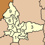
 Amphoe location in Nakhon Si Thammarat Province | |
| Coordinates: 8°25′34″N 99°30′17″E / 8.42611°N 99.50472°ECoordinates: 8°25′34″N 99°30′17″E / 8.42611°N 99.50472°E | |
| Country |
|
| Province | Nakhon Si Thammarat |
| Seat | Chawang |
| Area | |
| • Total | 528.2 km2 (203.9 sq mi) |
| Population (2005) | |
| • Total | 65,787 |
| • Density | 124.5/km2 (322/sq mi) |
| Time zone | THA (UTC+7) |
| Postal code | 80150 |
| Geocode | 8004 |
Chawang (Thai: ฉวาง) is a district (Amphoe) of Nakhon Si Thammarat Province, southern Thailand.
Geography
Neighboring districts are (from the northeast clockwise) Phipun, Lan Saka, Chang Klang, Na Bon, Thung Yai and Tham Phannara of Nakhon Si Thammarat, and Wiang Sa of Surat Thani Province.
The east of the district is part of the Khao Luang National Park.
Climate
| Climate data for Chawang (1981–2010) | |||||||||||||
|---|---|---|---|---|---|---|---|---|---|---|---|---|---|
| Month | Jan | Feb | Mar | Apr | May | Jun | Jul | Aug | Sep | Oct | Nov | Dec | Year |
| Record high °C (°F) | 37.5 (99.5) |
39.5 (103.1) |
39.1 (102.4) |
41.0 (105.8) |
39.5 (103.1) |
38.2 (100.8) |
36.2 (97.2) |
36.2 (97.2) |
35.4 (95.7) |
36.2 (97.2) |
38.3 (100.9) |
35.5 (95.9) |
41.0 (105.8) |
| Average high °C (°F) | 32.8 (91) |
34.6 (94.3) |
35.3 (95.5) |
35.5 (95.9) |
33.8 (92.8) |
32.9 (91.2) |
32.6 (90.7) |
32.6 (90.7) |
32.5 (90.5) |
31.8 (89.2) |
31.4 (88.5) |
31.5 (88.7) |
33.1 (91.6) |
| Daily mean °C (°F) | 26.2 (79.2) |
27.2 (81) |
27.9 (82.2) |
28.3 (82.9) |
27.6 (81.7) |
27.3 (81.1) |
26.9 (80.4) |
27.1 (80.8) |
26.9 (80.4) |
26.4 (79.5) |
26.3 (79.3) |
25.9 (78.6) |
27.0 (80.6) |
| Average low °C (°F) | 20.7 (69.3) |
20.3 (68.5) |
21.2 (70.2) |
22.1 (71.8) |
22.8 (73) |
22.7 (72.9) |
22.5 (72.5) |
22.5 (72.5) |
22.6 (72.7) |
22.7 (72.9) |
22.4 (72.3) |
21.5 (70.7) |
22.0 (71.6) |
| Record low °C (°F) | 15.0 (59) |
16.2 (61.2) |
16.2 (61.2) |
17.7 (63.9) |
17.5 (63.5) |
19.5 (67.1) |
19.2 (66.6) |
19.0 (66.2) |
19.5 (67.1) |
16.8 (62.2) |
17.7 (63.9) |
16.5 (61.7) |
15.0 (59) |
| Average rainfall mm (inches) | 38.4 (1.512) |
39.0 (1.535) |
116.9 (4.602) |
105.4 (4.15) |
206.2 (8.118) |
187.8 (7.394) |
192.1 (7.563) |
220.0 (8.661) |
243.0 (9.567) |
221.6 (8.724) |
203.9 (8.028) |
120.6 (4.748) |
1,894.9 (74.602) |
| Average rainy days | 7.6 | 3.9 | 9.9 | 12.2 | 18.2 | 17.8 | 19.3 | 20.0 | 20.8 | 24.0 | 17.5 | 12.5 | 183.7 |
| Average relative humidity (%) | 80 | 75 | 76 | 79 | 84 | 85 | 86 | 85 | 86 | 87 | 87 | 84 | 83 |
| Mean monthly sunshine hours | 198.4 | 180.8 | 201.5 | 183.0 | 155.0 | 150.0 | 114.7 | 151.9 | 144.0 | 108.5 | 138.0 | 142.6 | 1,868.4 |
| Mean daily sunshine hours | 6.4 | 6.4 | 6.5 | 6.1 | 5.0 | 5.0 | 3.7 | 4.9 | 4.8 | 3.5 | 4.6 | 4.6 | 5.1 |
| Source #1: Thai Meteorological Department[1] | |||||||||||||
| Source #2: Office of Water Management and Hydrology, Royal Irrigation Department (sun and humidity)[2] | |||||||||||||
Administration
The district is subdivided into 10 subdistricts (tambon), which are further subdivided into 84 villages (muban). There are 3 subdistrict municipalities (thesaban tambon) - Chan Di covers the whole tambon Chan Di, and Chawang and Mai Riang each cover parts of the same-named tambon. There are further 10 Tambon administrative organizations (TAO).
|
 |
Missing numbers are now part of the districts Tham Phannara and Chang Klang.
References
- ↑ "Climatological Data for the Period 1981–2010". Thai Meteorological Department. p. 24. Retrieved 8 August 2016.
- ↑ "ปริมาณการใช้น้ำของพืชอ้างอิงโดยวิธีของ Penman Monteith (Reference Crop Evapotranspiration by Penman Monteith)" (PDF) (in Thai). Office of Water Management and Hydrology, Royal Irrigation Department. p. 113. Retrieved 8 August 2016.