Ammerstol
| Ammerstol | ||
|---|---|---|
| Village | ||
| ||
| Coordinates: 51°55′39″N 4°48′31″E / 51.92750°N 4.80861°ECoordinates: 51°55′39″N 4°48′31″E / 51.92750°N 4.80861°E | ||
| Country | Netherlands | |
| Province | South Holland | |
| Municipality | Krimpenerwaard | |
| Population (2009) | 1,544 | |

Ammerstol is a village, part of the municipality of Krimpenerwaard in the Netherlands. It is located about 12 kilometres (7.5 mi) southeast of Gouda, on the Lek River.
Between 1817 and 1985, Ammerstol was an independent municipality.[1] Until 2015, it was part of Bergambacht.
Ammerstol has two listed Rijksmonuments: the 17th century inventory of its Reformed Church (itself built during 1880-81), and a thatched-roof farmhouse.[2]
-
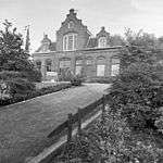
The former post office in Ammerstol
-
.jpg)
Ammerstol's Reformed Church
-
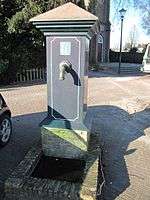
Village pump on the Kerkplein
References
- ↑ Ad van der Meer and Onno Boonstra, Repertorium van Nederlandse gemeenten, KNAW, 2006.
- ↑ See NL language List of Rijksmonuments in Ammerstol
| Wikimedia Commons has media related to Ammerstol. |
External links
- J. Kuyper, Gemeente Atlas van Nederland, 1865-1870, "Ammerstol". Map of the former municipality, around 1868.
This article is issued from Wikipedia - version of the 9/16/2015. The text is available under the Creative Commons Attribution/Share Alike but additional terms may apply for the media files.