Alna, Maine
| Alna, Maine | ||
|---|---|---|
| Town | ||
|
Alna Meeting House, built in 1789 | ||
| ||
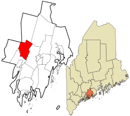 Location in Lincoln County and the state of Maine. | ||
| Coordinates: 44°5′6″N 69°37′31″W / 44.08500°N 69.62528°W | ||
| Country | United States | |
| State | Maine | |
| County | Lincoln | |
| Settled | 1760 | |
| Incorporated | 1794 | |
| Government | ||
| • Type | Town Meeting | |
| Area[1] | ||
| • Total | 21.32 sq mi (55.22 km2) | |
| • Land | 20.90 sq mi (54.13 km2) | |
| • Water | 0.42 sq mi (1.09 km2) | |
| Elevation | 128 ft (39 m) | |
| Population (2010)[2] | ||
| • Total | 709 | |
| • Estimate (2012[3]) | 709 | |
| • Density | 33.9/sq mi (13.1/km2) | |
| Time zone | Eastern (UTC-5) | |
| • Summer (DST) | Eastern (UTC-4) | |
| ZIP code | 04535 | |
| Area code(s) | 207 | |
| FIPS code | 23-01010 | |
| GNIS feature ID | 0582321 | |
| Website | http://alna.maine.gov | |

Alna is a town in Lincoln County, Maine, United States. The population was 709 at the 2010 census. Home to the Wiscasset, Waterville & Farmington Railway Museum, Alna includes the early mill village of Head Tide, noted for its historic architecture.
History

Originally a part of old Pownalborough, the town was settled around 1760 and incorporated in 1794 by the Massachusetts General Court as New Milford. But residents didn't like the name, so it was changed in 1811 to Alna, Latin for alder, the tree which grows in profusion along the banks of the Sheepscot River.[4]
Alna was the site of the first fish hatchery in Maine, started shortly after the Civil War. Between 1895 until 1933, Sheepscot Station was a stop on the narrow gauge Wiscasset, Waterville & Farmington Railway, which is now a heritage railway in town.[5]
Geography
According to the United States Census Bureau, the town has a total area of 21.32 square miles (55.22 km2), of which, 20.90 square miles (54.13 km2) of it is land and 0.42 square miles (1.09 km2) is water.[1] Alna is drained by the Sheepscot River.
The town in crossed by Maine State Route 194 and Maine State Route 218. It borders the towns of Wiscasset to the south, Dresden to the west, Pittston, Whitefield and Jefferson to the north, and across the Sheepscot River, Newcastle to the east.
Demographics
| Historical population | |||
|---|---|---|---|
| Census | Pop. | %± | |
| 1800 | 636 | — | |
| 1810 | 797 | 25.3% | |
| 1820 | 978 | 22.7% | |
| 1830 | 1,175 | 20.1% | |
| 1840 | 990 | −15.7% | |
| 1850 | 916 | −7.5% | |
| 1860 | 805 | −12.1% | |
| 1870 | 747 | −7.2% | |
| 1880 | 687 | −8.0% | |
| 1890 | 512 | −25.5% | |
| 1900 | 444 | −13.3% | |
| 1910 | 457 | 2.9% | |
| 1920 | 320 | −30.0% | |
| 1930 | 294 | −8.1% | |
| 1940 | 339 | 15.3% | |
| 1950 | 350 | 3.2% | |
| 1960 | 347 | −0.9% | |
| 1970 | 315 | −9.2% | |
| 1980 | 425 | 34.9% | |
| 1990 | 571 | 34.4% | |
| 2000 | 675 | 18.2% | |
| 2010 | 709 | 5.0% | |
| Est. 2014 | 714 | [6] | 0.7% |
2010 census
As of the census[2] of 2010, there were 709 people, 295 households, and 210 families residing in the town. The population density was 33.9 inhabitants per square mile (13.1/km2). There were 346 housing units at an average density of 16.6 per square mile (6.4/km2). The racial makeup of the town was 97.5% White, 0.1% African American, 1.1% Native American, 0.4% Asian, 0.1% from other races, and 0.7% from two or more races. Hispanic or Latino of any race were 0.6% of the population.
There were 295 households of which 28.1% had children under the age of 18 living with them, 60.0% were married couples living together, 6.8% had a female householder with no husband present, 4.4% had a male householder with no wife present, and 28.8% were non-families. 21.0% of all households were made up of individuals and 6.7% had someone living alone who was 65 years of age or older. The average household size was 2.40 and the average family size was 2.78.
The median age in the town was 45.7 years. 20.9% of residents were under the age of 18; 5.5% were between the ages of 18 and 24; 22.1% were from 25 to 44; 35.2% were from 45 to 64; and 16.2% were 65 years of age or older. The gender makeup of the town was 48.7% male and 51.3% female.
2000 census
As of the census[8] of 2000, there were 675 people, 266 households, and 197 families residing in the town. The population density was 32.3 people per square mile (12.5/km²). There were 315 housing units at an average density of 15.1 per square mile (5.8/km²). The racial makeup of the town was 99.56% White, 0.30% Native American and 0.15% Asian. Hispanic or Latino of any race were 0.15% of the population. 0.1% African Americans.
There were 266 households out of which 34.6% had children under the age of 18 living with them, 64.3% were married couples living together, 6.4% had a female householder with no husband present, and 25.6% were non-families. 19.9% of all households were made up of individuals and 9.4% had someone living alone who was 65 years of age or older. The average household size was 2.54 and the average family size was 2.94.
In the town the population was spread out with 25.0% under the age of 18, 4.9% from 18 to 24, 27.4% from 25 to 44, 28.6% from 45 to 64, and 14.1% who were 65 years of age or older. The median age was 41 years. For every 100 females there were 99.7 males. For every 100 females age 18 and over, there were 96.9 males.
The median income for a household in the town was $43,125, and the median income for a family was $48,611. Males had a median income of $34,375 versus $23,977 for females. The per capita income for the town was $17,340. About 6.7% of families and 6.3% of the population were below the poverty line, including 5.7% of those under age 18 and 10.1% of those age 65 or over.
Sites of interest

- Alna Meetinghouse (1789)
- Alna School (1795)
- Wiscasset, Waterville and Farmington Railway Museum
Notable people
- Fred H. Albee, surgeon
- John T. Averill, US congressman
- George E. Bailey, murder victim
- Edwin Arlington Robinson, poet
- Daniel Rose, fourth governor of Maine
References
- 1 2 "US Gazetteer files 2010". United States Census Bureau. Retrieved 2012-12-16.
- 1 2 "American FactFinder". United States Census Bureau. Retrieved 2012-12-16.
- ↑ "Population Estimates". United States Census Bureau. Archived from the original on 2013-06-17. Retrieved 2013-07-06.
- ↑ Coolidge, Austin J.; John B. Mansfield (1859). A History and Description of New England. Boston, Massachusetts. p. 29.
- ↑ WW&F Railway History
- ↑ "Annual Estimates of the Resident Population for Incorporated Places: April 1, 2010 to July 1, 2014". Retrieved June 4, 2015.
- ↑ "Census of Population and Housing". Census.gov. Archived from the original on May 11, 2015. Retrieved June 4, 2015.
- ↑ "American FactFinder". United States Census Bureau. Archived from the original on 2013-09-11. Retrieved 2008-01-31.
External links
- Contact information for Alna, Maine
- Sheepscot River Watershed Council
- City Data profile
- Epodunk profile
- Sheepscot Valley Conservation Association
Municipalities and communities of Lincoln County, Maine, United States | ||
|---|---|---|
| Towns | 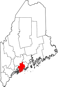 | |
| Plantation | ||
| Gore | ||
| CDPs | ||
| Other villages | ||
Coordinates: 44°06′22″N 69°36′13″W / 44.10611°N 69.60361°W