Alma, Alabama
| Alma, Alabama | |
|---|---|
| Unincorporated community | |
 Alma, Alabama  Alma, Alabama Location within the state of Alabama | |
| Coordinates: 31°27′50.4″N 87°45′10.8″W / 31.464000°N 87.753000°W | |
| Country | United States |
| State | Alabama |
| County | Clarke |
| Elevation | 259 ft (79 m) |
| Time zone | Central (CST) (UTC-6) |
| • Summer (DST) | CDT (UTC-5) |
| ZIP code | 36501 |
| Area code(s) | 251 |
Alma is an unincorporated community in Clarke County, Alabama, United States. The community was named for Alma Flinn, a local teacher.[1]
Geography
Alma is located at 31°27′50″N 87°45′11″W / 31.464°N 87.753°WCoordinates: 31°27′50″N 87°45′11″W / 31.464°N 87.753°W and has an elevation of 259 feet (79 m).[1]
References
- 1 2 "Alma, Alabama". "ePodunk Community Profiles". Retrieved 2008-01-16.
Municipalities and communities of Clarke County, Alabama, United States | ||
|---|---|---|
| Cities | 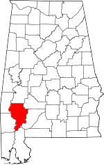 | |
| Towns | ||
| CDPs | ||
| Unincorporated communities | ||
| Ghost towns | ||
This article is issued from Wikipedia - version of the 7/29/2016. The text is available under the Creative Commons Attribution/Share Alike but additional terms may apply for the media files.