Alexo, Alberta

Alexo is a ghost town in Alberta, Canada. Built as a coal mining town, it is located near the David Thompson Highway, between Nordegg and Rocky Mountain House, at an elevation of about 1,260 metres (4,130 ft). Shunda Creek runs to the south of it, not far from its confluence with the North Saskatchewan River.[1]
History
In 1913 the opening of the Brazeau Branch rail line to the coal mine at Nordegg created access to markets, and other mining ventures soon started near the tracks. The mine at Alexo, which was named after the Alexo Coal Company, was one of them.[2]
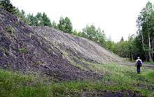
The coal in the Alexo area is part of the Coalspur Formation and is of early Paleocene age.[1] The mine operated from 1920 to 1955, and by 1948 annual production was about 33,000 tonnes. The payroll included about 70 people, of whom 30 were miners. There was a hotel, a cookhouse, a bunkhouse, a store, and 30 cottages.[3]
The mine worked a single seam that was consistently about 5 feet (1.5m) thick, with a shallow dip to the northeast. Mining was done by underground room and pillar methods. By 1948 the main slope had advanced to a length of 824 metres (2,700 ft), and levels driven from both sides covered a total east-west distance of 2,012 metres (6,600 ft).[3]
The Alexo mine closed in 1955 due to declining markets for steam coal as the railroads replaced steam locomotives with diesel,[4] and the town was eventually dismantled.
Most of the former Alexo townsite is now leased by the Provincial government to the Youth and Volunteer Centre of Red Deer, Alberta and is home to a summer camp called Camp Alexo.
References
- 1 2 Erdman, O.A., 1950. Alexo and Saunders Map-Areas, Alberta. Geological Survey of Canada, Memoir 254, 100 p.
- ↑ Belliveau, Anne (1999). Small moments in time, the story of Alberta's Big West country. Calgary, Alberta: Detselig Enterprises Ltd, 238 p. ISBN 1-55059-178-9.
- 1 2 Pullen, P.F. and Tennant, R. 1948. Alexo has quality products. Western Miner 21(8): 88-89, August 1948.
- ↑ Dutton, J.A. 1954. Alberta coal output declines. Western Miner 27(4): 42, 44-46, April 1954.
Coordinates: 52°28′27″N 115°47′24″W / 52.474059°N 115.789885°W