Aleksandrów Kujawski
| Aleksandrów Kujawski | ||
|---|---|---|
|
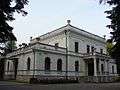
Church of the Transfiguration, built 1880-1886. | ||
| ||
 Aleksandrów Kujawski | ||
| Coordinates: 52°52′N 18°42′E / 52.867°N 18.700°E | ||
| Country |
| |
| Voivodeship | Kuyavian-Pomeranian | |
| County | Aleksandrów | |
| Gmina | Aleksandrów Kujawski (urban gmina) | |
| Government | ||
| • Mayor | Andrzej Cieśla | |
| Area | ||
| • Total | 7.17 km2 (2.77 sq mi) | |
| Population (2014) | ||
| • Total | 12,476 | |
| • Density | 1,700/km2 (4,500/sq mi) | |
| Time zone | CET (UTC+1) | |
| • Summer (DST) | CEST (UTC+2) | |
| Postal code | 87-700 to 87-712 | |
| Car plates | CAL | |
| Website | http://www.aleksandrowkujawski.pl | |

Aleksandrów Kujawski [alɛkˈsandruf kuˈjafskʲi] (Polish: until 1879 Trojanów, 1879-1919 Aleksandrów Pograniczny, {German 1939–1943 Alexandrow (Weichsel), German-nazi 1943-45 Weichselstädt) is a small town in Poland, in Kuyavian-Pomeranian Voivodeship. It is situated about 18 km south-east of Toruń. It is the seat of Aleksandrów County, and also of Gmina Aleksandrów Kujawski (although it is not part of the territory of that gmina).
Districts
- Centrum
- Osiedle Parkowa I (Bloki)
- Osiedle Parkowa II (Bloki)
- Piaski (Piachy)
- Halinowo
- Osiedle Południe
Geographical location: 52°53' N, 18°42' E; 88 metres above sea level
Area: 7,17 km²
Population: 12,476
Founded in 1862
Municipal rights in 1879
| Wikimedia Commons has media related to Aleksandrów Kujawski. |
Image gallery

Look in
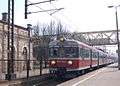
Aleksandrów Kujawski (PKP station)
External links
| Urban gminas |  | |
|---|---|---|
| Rural gminas | ||
Coordinates: 52°52′N 18°42′E / 52.867°N 18.700°E
This article is issued from Wikipedia - version of the 10/10/2016. The text is available under the Creative Commons Attribution/Share Alike but additional terms may apply for the media files.