Alamo, Georgia
| Alamo, Georgia | |
|---|---|
| City | |
|
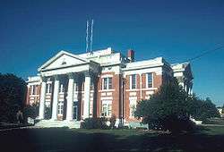
Wheeler County Courthouse (Built 1913), Alamo, Georgia | |
 Location in Wheeler County and the state of Georgia | |
| Coordinates: 32°8′54″N 82°46′43″W / 32.14833°N 82.77861°WCoordinates: 32°8′54″N 82°46′43″W / 32.14833°N 82.77861°W | |
| Country | United States |
| State | Georgia |
| County | Wheeler |
| Area | |
| • Total | 1.9 sq mi (5 km2) |
| • Land | 1.9 sq mi (5 km2) |
| • Water | 0 sq mi (0 km2) |
| Elevation | 230 ft (70 m) |
| Population (2010) | |
| • Total | 2,797 |
| • Density | 1,022.6/sq mi (388.6/km2) |
| Time zone | Eastern (EST) (UTC-5) |
| • Summer (DST) | EDT (UTC-4) |
| ZIP code | 30411 |
| Area code(s) | 912 |
| FIPS code | 13-00996[1] |
| GNIS feature ID | 0331008[2] |
Alamo is a city in Wheeler County, Georgia, United States. As of the 2010 census, the city had a population of 2,797.[3] The city is the county seat of Wheeler County.[4]
History
Alamo was founded in 1890 as a stop on the Seaboard Air Line Railroad. It was named for the Alamo Mission in San Antonio, Texas.[5]
Alamo's courthouse was built in 1913 and is on the National Register of Historical Places. The Lamplighter Little Theatre dates back to 1919.
Geography
Alamo is located at 32°8′54″N 82°46′43″W / 32.14833°N 82.77861°W.[6]
According to the United States Census Bureau, the city has a total area of 1.9 square miles (4.9 km2), of which, 1.9 square miles (4.9 km2) of it is land and 0.52% is water.
Demographics
| Historical population | |||
|---|---|---|---|
| Census | Pop. | %± | |
| 1910 | 249 | — | |
| 1920 | 563 | 126.1% | |
| 1930 | 613 | 8.9% | |
| 1940 | 646 | 5.4% | |
| 1950 | 800 | 23.8% | |
| 1960 | 822 | 2.8% | |
| 1970 | 833 | 1.3% | |
| 1980 | 993 | 19.2% | |
| 1990 | 855 | −13.9% | |
| 2000 | 1,943 | 127.3% | |
| 2010 | 2,797 | 44.0% | |
| Est. 2015 | 3,330 | [7] | 19.1% |
As of the census[1] of 2000, there were 1,943 people, 363 households, and 255 families residing in the city. The population density was 1,014.5 people per square mile (390.7/km²). There were 414 housing units at an average density of 216.2 per square mile (83.3/km²). The racial makeup of the city was 46.37% White, 52.60% African American, 0.57% from other races, and 0.46% from two or more races. Hispanic or Latino of any race were 0.93% of the population.
There were 363 households out of which 33.9% had children under the age of 18 living with them, 44.4% were married couples living together, 21.5% had a female householder with no husband present, and 29.5% were non-families. 28.1% of all households were made up of individuals and 16.0% had someone living alone who was 65 years of age or older. The average household size was 2.58 and the average family size was 3.14.
In the city the population was spread out with 14.3% under the age of 18, 14.1% from 18 to 24, 44.9% from 25 to 44, 19.4% from 45 to 64, and 7.4% who were 65 years of age or older. The median age was 35 years. For every 100 females there were 257.8 males. For every 100 females age 18 and over, there were 323.9 males.
The median income for a household in the city was $25,000, and the median income for a family was $30,125. Males had a median income of $25,921 versus $20,208 for females. The per capita income for the city was $8,147. About 24.9% of families and 24.8% of the population were below the poverty line, including 30.4% of those under age 18 and 25.6% of those age 65 or over.
Education
Wheeler County School District
The Wheeler County School District holds grades pre-school to grade twelve, and consists of one elementary school and a middle-high school.[9] The district has 82 full-time teachers and over 1,150 students.[10]
- Wheeler County Elementary School
- Wheeler County High School
References
- 1 2 "American FactFinder". United States Census Bureau. Archived from the original on 2013-09-11. Retrieved 2008-01-31.
- ↑ "US Board on Geographic Names". United States Geological Survey. 2007-10-25. Retrieved 2008-01-31.
- ↑ http://factfinder2.census.gov/faces/tableservices/jsf/pages/productview.xhtml?pid=DEC_10_SF1_GCTP2.ST13&prodType=table
- ↑ "Find a County". National Association of Counties. Archived from the original on May 31, 2011. Retrieved 2011-06-07.
- ↑ Hellmann, Paul T. (May 13, 2013). Historical Gazetteer of the United States. Routledge. p. 215. Retrieved 30 November 2013.
- ↑ "US Gazetteer files: 2010, 2000, and 1990". United States Census Bureau. 2011-02-12. Retrieved 2011-04-23.
- ↑ "Annual Estimates of the Resident Population for Incorporated Places: April 1, 2010 to July 1, 2015". Retrieved July 2, 2016.
- ↑ "Census of Population and Housing". Census.gov. Archived from the original on May 11, 2015. Retrieved June 4, 2015.
- ↑ Georgia Board of Education, Retrieved June 30, 2010.
- ↑ School Stats, Retrieved June 30, 2010.
Municipalities and communities of Wheeler County, Georgia, United States | ||
|---|---|---|
| Cities | 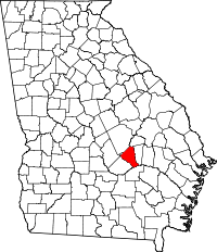 | |
| Footnotes | ‡This populated place also has portions in an adjacent county or counties | |