El Qoseir
| El Qoseir | |
|---|---|
 El Qoseir Location in Egypt | |
| Coordinates: 26°06′14″N 34°16′52″E / 26.10389°N 34.28111°E | |
| Country |
|
| Governorate | Red Sea |
| Time zone | EST (UTC+2) |
El Qoseir[other spellings 1] (Arabic: القصير El Oṣēr Egyptian Arabic pronunciation: [elʔoˈsˤeːɾ]) is a city in eastern Egypt, located on the Red Sea coast. Populated for approximately 5,000 years, its ancient name was Leucus Limen (meaning white port in Greek, Λευκός Λιμήν). El Qoseir is located 138 kilometers south of Hurghada, 139 km north of Marsa Alam and 73 km north of the Marsa Alam International Airport. In 1986, its population was approximately 20,000. Today, the population of El Qoseir is around 50,000.
Climate
Köppen-Geiger climate classification system classifies its climate as hot desert (BWh). Summers are hot and winters are warm. Winter night temperatures in El Qoseir, along with those of Marsa Alam and Sharm El Sheikh are the warmest of any other cities and resorts in Egypt. Additionally, Port Said, El Qoseir, Ras El Bar, Baltim, Damietta and Alexandria have the least temperature variation. Rain is very rare as in most of Egypt. Seasonal variation is small, comparable to Marsa Alam, but its summer days are cooler, even cooler than similar more northern areas at the Red Sea, like Hurghada and Sharm El Sheikh.
The highest record temperature was 46 °C (115 °F), recorded on July 12, 1983, while the coldest record temperature was 1 °C (34 °F), recorded on January 6, 1976.[1]
| Climate data for El Qoseir | |||||||||||||
|---|---|---|---|---|---|---|---|---|---|---|---|---|---|
| Month | Jan | Feb | Mar | Apr | May | Jun | Jul | Aug | Sep | Oct | Nov | Dec | Year |
| Record high °C (°F) | 30.4 (86.7) |
31.4 (88.5) |
38.3 (100.9) |
42.2 (108) |
44.6 (112.3) |
41.0 (105.8) |
37.6 (99.7) |
38.3 (100.9) |
36.4 (97.5) |
36.7 (98.1) |
32.8 (91) |
31.3 (88.3) |
44.6 (112.3) |
| Average high °C (°F) | 21.9 (71.4) |
22.6 (72.7) |
24.5 (76.1) |
27.1 (80.8) |
29.8 (85.6) |
31.8 (89.2) |
32.6 (90.7) |
32.7 (90.9) |
31.6 (88.9) |
29.3 (84.7) |
24.7 (76.5) |
23.2 (73.8) |
27.7 (81.9) |
| Daily mean °C (°F) | 17.8 (64) |
18.5 (65.3) |
20.5 (68.9) |
23.5 (74.3) |
26.4 (79.5) |
28.8 (83.8) |
29.6 (85.3) |
29.9 (85.8) |
28.3 (82.9) |
25.9 (78.6) |
22.5 (72.5) |
19.2 (66.6) |
24.2 (75.6) |
| Average low °C (°F) | 13.8 (56.8) |
14.3 (57.7) |
16.4 (61.5) |
19.7 (67.5) |
22.7 (72.9) |
25.4 (77.7) |
26.1 (79) |
26.4 (79.5) |
25.0 (77) |
22.4 (72.3) |
17.8 (64) |
15.5 (59.9) |
20.5 (68.9) |
| Record low °C (°F) | 9.0 (48.2) |
8.8 (47.8) |
9.2 (48.6) |
12.7 (54.9) |
16.6 (61.9) |
21.2 (70.2) |
21.3 (70.3) |
23.0 (73.4) |
18.1 (64.6) |
17.5 (63.5) |
12.4 (54.3) |
9.3 (48.7) |
8.8 (47.8) |
| Average precipitation mm (inches) | 0 (0) |
0 (0) |
0 (0) |
0 (0) |
0 (0) |
0 (0) |
0 (0) |
0 (0) |
0 (0) |
1 (0.04) |
1 (0.04) |
1 (0.04) |
3 (0.12) |
| Average precipitation days (≥ 1.0 mm) | 0 | 0 | 0.1 | 0.1 | 0 | 0 | 0 | 0 | 0 | 0.3 | 0.5 | 0 | 1.0 |
| Average relative humidity (%) | 51 | 48 | 50 | 50 | 48 | 48 | 50 | 51 | 54 | 56 | 54 | 54 | 51.2 |
| Mean daily sunshine hours | 9 | 10 | 10 | 10 | 11 | 13 | 13 | 12 | 11 | 10 | 10 | 9 | 10.7 |
| Source #1: NOAA,[2] Climate Charts[3] | |||||||||||||
| Source #2: Voodoo Skies for record temperatures,[1] Weather2Travel for sunshine[4] | |||||||||||||
| Jan | Feb | Mar | Apr | May | Jun | Jul | Aug | Sep | Oct | Nov | Dec |
|---|---|---|---|---|---|---|---|---|---|---|---|
| 23 °C (73 °F) | 22 °C (72 °F) | 22 °C (72 °F) | 23 °C (73 °F) | 25 °C (77 °F) | 26 °C (79 °F) | 28 °C (82 °F) | 29 °C (84 °F) | 28 °C (82 °F) | 27 °C (81 °F) | 26 °C (79 °F) | 24 °C (75 °F) |
Gallery
 In the old city
%2B.jpg) On the streets of El Qoseir
On the streets of El Qoseir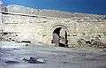 Fortress in El Qoseir (1968)
See also
Notes
- ↑ Also spelled: Kosseir, Al Qusair, El Quseir, Quseir, Qusseir, Qosseir
References
- 1 2 "Quseir, Egypt". Voodoo Skies. Retrieved 13 August 2013.
- ↑ "Kosseir Climate Normals 1961–1990". National Oceanic and Atmospheric Administration. Retrieved January 17, 2016.
- ↑ "Kosseir, Egypt: Climate, Global Warming, and Daylight Charts and Data". Retrieved 9 July 2013.
- 1 2 "El Quseir Climate and Weather Averages, Egypt". Weather2Travel. Retrieved 2014-01-06.
External links
Coordinates: 26°06′14″N 34°16′52″E / 26.10389°N 34.28111°E