Ait Ourir
| Ait Ourir | |
|---|---|
| Municipality and town | |
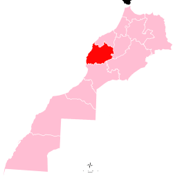
 Ait Ourir Location in Morocco | |
| Coordinates: 31°33′52″N 7°39′46″W / 31.56444°N 7.66278°WCoordinates: 31°33′52″N 7°39′46″W / 31.56444°N 7.66278°W | |
| Country |
|
| Region | Marrakech-Tensift-Al Haouz |
| Province | Al Haouz Province |
| Population (2004) | |
| • Total | 20,005 |
| Time zone | WET (UTC+0) |
| • Summer (DST) | WEST (UTC+1) |
Ait Ourir is a town and municipality in Al Haouz Province, Marrakech-Tensift-Al Haouz, Morocco. At the time of the 2004 census, the commune had a total population of 20,005 people living in 3767 households.[1]The town lies on the northern bank of the Ourika River, 29.8 kilometres (18.5 mi) by road to the northwest of Tighedouine and 33.3 kilometres (20.7 mi) east of the city centre of Marrakesh.[2]
Landmarks
The town, described by Footprint Travel Guides as "rather undistinguished",[3] contains a number of important buildings, a hospital, cemetery and several schools such as College Moulay Rachid and Ecole Riyad. The souk of Ait Ourir is of importance to trade in Al Haouz province, with a large market trading agricultural produce, camels, sheep and other items here. A shop at the souk sells tagines cooked over kanounes (cauldrons).[4]Glaoui appears to be an ancient village in the area to the southeast of the town which has effectively become a suburb which contains a kasbah and a mosque.[2] To the southeast is the Ait Ourir Forest. Quartz is mined within the municipality.[5] There are eucalyptus and olive plantations in the area.[3]
Notable people
- Abdelaziz Lemsioui (1944-) - Deputy of Commune from 1984 to 1992 and Regional Councillor of Marrakech-Tensift-Al Haouz from 1996 to 2000.[6]
References
- ↑ "Recensement général de la population et de l'habitat de 2004" (PDF). Haut-commissariat au Plan, Lavieeco.com. Archived from the original (PDF) on 23 April 2012. Retrieved 7 June 2012.
- 1 2 Maps (Map). Google Maps.
- 1 2 McGuinness, Justin (1 March 2002). Footprint Marrakech & the High Atlas Handbook: The Travel Guide. Footprint Travel Guides. p. 179. ISBN 978-1-903471-12-8. Retrieved 7 June 2012.
- ↑ Hal, Fatéma (15 May 2002). Food of Morocco: Authentic Recipes from the North African Coast. Tuttle Publishing. p. 7. ISBN 978-962-593-992-6. Retrieved 7 June 2012.
- ↑ International Association of Scientific Hydrology; International Union of Geodesy and Geophysics (1951). Assemblée générale de Bruxelles, 1951. Impr. Ceuterick. p. 10. Retrieved 7 June 2012.
- ↑ Park, Thomas Kerlin; Boum, Aomar (2006). Historical Dictionary of Morocco. Scarecrow Press. p. 216. ISBN 978-0-8108-5341-6. Retrieved 7 June 2012.