Airport Connector (Harrisburg)
| |
|---|---|
| Airport Connector | |
 | |
| Route information | |
| Maintained by PennDOT | |
| Length: | 1.940 mi[1] (3.122 km) |
| Major junctions | |
| South end: |
|
|
| |
| North end: |
|
| Location | |
| Counties: | Dauphin |
| Highway system | |

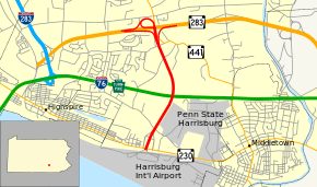
The Airport Connector is a 1.9-mile (3.1 km) freeway in the Harrisburg, Pennsylvania, area in the United States. It begins at Pennsylvania Route 283 (PA 283) and ends at Harrisburg International Airport. There is one intermediate exit with PA 230. The highway is internally designated as State Route 3032 by the Pennsylvania Department of Transportation.
Route description

The Airport Connector begins at the entrance to Harrisburg International Airport in Lower Swatara Township, Dauphin County, where the roadway continues south to loop around the terminal. Past the airport, the road passes over Amtrak's Philadelphia to Harrisburg Main Line immediately before reaching an interchange with PA 230. From this point, the four-lane freeway heads north through wooded areas adjacent to homes and farms, crossing over the Pennsylvania Turnpike (I-76) without an interchange. The freeway passes more areas of farms and woods before it reaches its terminus at an interchange with PA 283. PA 441 also passes through this interchange, but does not have direct access to the Airport Connector.[2]
Exit list
The entire route is in Lower Swatara Township, Dauphin County. All exits are unnumbered.
| mi[1] | km | Destinations | Notes | ||
|---|---|---|---|---|---|
| 0.000 | 0.000 | ||||
| 0.261 | 0.420 | ||||
| 1.940 | 3.122 | ||||
| 1.000 mi = 1.609 km; 1.000 km = 0.621 mi | |||||
See also
 U.S. Roads portal
 Pennsylvania portal
References
- 1 2 Bureau of Maintenance and Operations (January 2015). Roadway Management System Straight Line Diagrams (Report) (2015 ed.). Pennsylvania Department of Transportation. Retrieved June 30, 2015.
- Dauphin County (PDF)
- ↑ Google (2010-12-24). "overview of Airport Connector" (Map). Google Maps. Google. Retrieved 2010-12-24.
External links
| Wikimedia Commons has media related to Airport Connector (Harrisburg). |