Achaphubuil

Coordinates: 56°50′10″N 5°08′25″W / 56.83622°N 5.14036°W
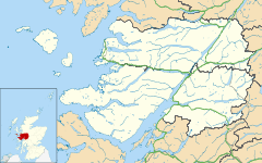
Achaphubuil (Scottish Gaelic: Achadh a' Phùbaill- the field of the tent or pavilion) is a small settlement in the north of Ardgour, in Lochaber, in the Highland council area of Scotland. Achaphubuil lies to the south of The Narrows, which link Loch Linnhe to Loch Eil. The village of Corpach is on the opposite shore, with Fort William across Loch Linnhe to the north-east.
The town is located on the south shore of Loch Eil and is within the Highland region and is in the Scottish council area of the Highland. The prefix "Aber-" refers to a confluence.
Achaphubuil is spread out along the A861 road, which runs along the shore of the loch.[1][2]
There was a foot ferry between Achaphubuil and Corpach across Loch Eil.
Achaphubuil had a primary school, but it closed in 2010.
References
| Wikimedia Commons has media related to Achaphubuil. |