Abu Rawash
Coordinates: 30°01′55″N 31°04′30″E / 30.03194°N 31.07500°E


Abu Rawash (also spelled Abu Roach, Abu Roash; Arabic: ابو رواش Egyptian Arabic pronunciation: [ˈæbu ɾæˈwæːʃ]), 8 km to the North of Giza, is the site of Egypt's most northerly pyramid, also known as the lost pyramid — the mostly ruined Pyramid of Djedefre, the son and successor of Khufu. Originally, it was thought that this pyramid had never been completed, but the current archaeological consensus is that not only was it completed, but that it was built about the same size as the Pyramid of Menkaure – the third largest of the Giza pyramids. One notable fact about the pyramid at Abu Roash is that the upper most part of the pyramid has seemingly disappeared, revealing the internal passage that runs down into the bedrock. Explanations to why this pyramid is missing its top vary. The second point of interest that this pyramid provides is that it is built on top of a hillock. The builders faced the colossal task of not only hauling megalithic stones up a pyramid but also up a hillock.
Detail

Its location adjacent to a major crossroads made it an easy source of stone. Quarrying — which began in Roman times — has left little apart from a few courses of stone superimposed upon the natural hillock that formed part of the pyramid's core.
Geology of Abu Rawash
The sedimentary succession in Abu Rawash area ranges in age from Late Cretaceous to Quaternary but is punctuated by several unconformity surfaces. Turonian to Coniacian representing the sedimentary succession of Abu Rawash Formation that differentiated into six informal units (members) from younger to older as follows:
- Basal clastic member
- Rudist-bearing limestone-marl member
- Limestone member
- Actaeonella-bearing limestone-marl member
- Flint-bearing chalky limestone member
- Plicatula-bearing marl-limestone member.
Sedimentary depositional environment of Abu Rawash Formation are characterized by variable conditions and settings ranging from lower mixed to upper intertidal flat and subtidal channel for the clastic facies and calm to agitated open marine inner to middle platform for the carbonate facies. Vertical sequence or facies hierarchy display that the facies sequence of the basal clastic member indicates a progradational preitidal sequence. While those of the rudist-bearing member and limestone member represent a cyclic progradtion of high energetic/storm facies above an open marine low energetic fore shoal subtidal facies. The facies sequence of the Acteonella-bearing member reflects two facies associations comprising open marine subtidal assemblage and shoal or bank facies. The latter facies represents the bank that the robust thick shelled Durania arnaudi with the coralline sponge heads accreted local mounds in restricted areas El-Hassana dome. The vertical facies hierarchy of the flint-bearing chalky limestone member suggests a renewed shoaling of the depositional accommodation, shifting to inner-platform setting and a progradation of mobile bioclastic shoals or banks. The stacking of the sedimentary facies in the Plicatula-bearing member indicates an accumulation in an open shallow sea (inner platform) with intermittent supply of fine terrigenous clastics and clays. (Hanan.S.M. Badawy, Geology Dept., Faculty of Science, Beni Suef, Egypt)
See also
External links
- Newsweek's Interactive Graphic on Djedefre's pyramid with Interactive Timeline of the major pyramids of ancient Egypt
- Information with interactive map, videos & photos of Abu Roash at Talking Pyramids
| City | 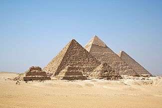 | |
|---|---|---|
| Abu Rawash | ||
| Giza | ||
| Abusir | ||
| Saqqara | ||
| Dahshur | ||
| See also | ||