Route 8 (Hong Kong)
| ||||
|---|---|---|---|---|
| Tsing Sha Highway (Sha Tin T3, Tai Wai Tunnel, Sha Tin Heights Tunnel, Eagle's Nest Tunnel, Lai Chi Kok Viaduct, Stonecutters Bridge, Nam Wan Tunnel), Lantau Link (Tsing Ma Bridge, Ma Wan Viaduct, Kap Shui Mun Bridge), North Lantau Highway | ||||
|
Route 8 coloured red | ||||
| Route information | ||||
| Part of AH368 | ||||
| Maintained by Highways Department | ||||
| Length: |
33.1 km (20.6 mi) 32.6 kilometres (20.3 mi) eastbound | |||
| Existed: | 1997 – present | |||
| Major junctions | ||||
| East end: |
| |||
|
Penny's Bay Highway near Sunny Bay/Yam O | ||||
| West end: | Airport Road near Hong Kong International Airport | |||
| Location | ||||
| Districts: | Sha Tin, Sham Shui Po, Kwai Tsing, Tsuen Wan, Islands | |||
| Highway system | ||||
|
Hong Kong Strategic Route and Exit Number System
| ||||

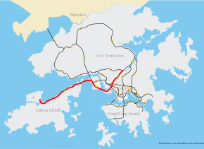
Route 8 (Chinese: 八號幹線) of Hong Kong is a dual 3-lane carriageway expressway that links Lantau Island, Tsing Yi Island, Cheung Sha Wan in West Kowloon, and Sha Tin in the southeast New Territories of Hong Kong. It is a combination of many sections.
The section from Lantau to Tsing Yi is made up of the existing North Lantau Highway and Lantau Link, which opened in 1997. Route 8 becomes Airport Road at Chek Lap Kok.
The section between Tsing Yi and Cheung Sha Wan, formerly known as Route 9, is a 7.6-kilometre (4.7 mi) dual 3-lane expressway. This section consists of the Stonecutters Bridge, which spans the Rambler Channel from Stonecutters Island and links with the Lantau Link through the Nam Wan Tunnel and West Tsing Yi viaduct and was opened on 20 December 2009. This section provides traffic with a more direct route to the Lantau Link, particularly vehicles from Tsim Sha Tsui and Western Harbour Crossing, previously vehicles had to use Route 3 (Cheung Tsing Bridge and Cheung Tsing Tunnel).
The remaining section links Cheung Sha Wan and Tai Wai, formerly known as Route 16. It is composed of the Eagle's Nest Tunnel and Sha Tin Heights Tunnel, totalling 6.7 kilometres (4.2 mi) in length and connecting Route 9 at its Sha Tin terminus. It was opened on 21 March 2008.[1][2]
Areas passed through by Route 8 include Hong Kong International Airport, Tung Chung, Hong Kong Disneyland, Ma Wan, Tsing Yi, West Kowloon, and Sha Tin.
Route 8 also connects with Route 3, Route 7, and Route 9.
Observed roads and exits
| Westbound towards Chek Lap Kok | Eastbound towards Sha Tin | ||
| Exit | Destination | Exit | Destination |
| Sha Tin (intersection with Route 9) | |||
| Tsing Sha Highway | |||
| 1 | Mei Tin Road | 1 | Mei Tin Road
Tai Wai, Route 9 clockwise to Tsuen Wan via Shing Mun Tunnels |
| 1A | Tai Po Road | ||
| Tai Wai Tunnel | |||
| 1B | Che Kung Miu Road | ||
| Sha Tin Heights Tunnel | |||
| Eagle's Nest Tunnel | |||
| Lai Chi Kok Viaduct | |||
| 1C | Ching Cheung Road (westbound)
Route 7 westbound to Kwai Chung |
||
| 2A | Lai Wan Interchange
Cheung Sha Wan and Hong Kong (West) (Route 3 southbound) |
||
| 2B | West Kowlooon Highway
Route 3 southbound to Tsim Sha Tsui and Hong Kong | ||
| 2C | Container Port Road South | ||
| 2D | Container Port Road South | ||
| Stonecutters Bridge | |||
| 3 | Tsing Yi Road | 3 | Tsing Yi Road
Tsing Yi, Container Terminal 9 |
| Nam Wan Tunnel | |||
| 3A | Ting Kau Bridge
Route 3 northbound to Yuen Long via Tai Lam Tunnel |
||
| 4A | Cheung Tsing Tunnel
Route 3 southbound to Hong Kong West, Kowloon, Tsuen Wan and Kwai Chung | ||
| 4B | Ting Kau Bridge
Route 3 northbound to Yuen Long via Tai Lam Tunnel | ||
| Tsing Ma Bridge | |||
| 4C | Ma Wan Road
Ma Wan (with authorized permit only) |
||
| Kap Shui Mun Bridge | |||
| North Lantau Highway | |||
| 5 | Penny's Bay Highway
Disneyland and Sunny Bay |
5 | Penny's Bay Highway
Disneyland and Sunny Bay |
| 6 | Siu Ho Wan Depot | 6 | Siu Ho Wan Depot |
| 6A | Yu Tung Road
Tung Chung Town Centre |
||
| 6B | Tung Chung Waterfront Road
Tung Chung North |
||
| Hong Kong International Airport | |||
See also
References
- ↑ "八號幹線沙田至長沙灣通車". Mingpao. 2008-03-21.
- ↑ "Route 8 between Cheung Sha Wan and Sha Tin". Highways Department. Retrieved 2008-02-18.
External links
- Details of Route 8 between Cheung Sha Wan and Sha Tin
- Details of Route 8 between Tsing Yi and Cheung Sha Wan
- Highway Departments: Route 8 - between Tsing Yi and Cheung Sha Wan
| Across the whole continent | 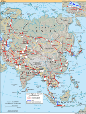 | |
|---|---|---|
| Southeast Asia | ||
| East Asia, Northeast Asia and Southeast Asia | ||
| South Asia | ||
| North Asia, Central Asia and Southwest Asia | ||