1983–84 South Pacific cyclone season
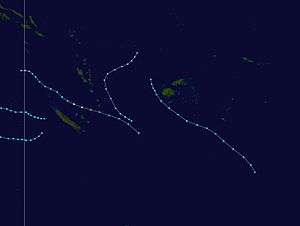 | |
| Season summary map | |
| First system formed | December 27, 1983 |
|---|---|
| Last system dissipated | March 30, 1984 |
| Strongest storm1 | Beti – 970 hPa (mbar), 120 km/h (75 mph) (10-minute sustained) |
| Total depressions | 7 |
| Tropical cyclones | 7 |
| Severe tropical cyclones | 1 |
| Total fatalities | Unknown |
| Total damage | Unknown |
| 1Strongest storm is determined by lowest pressure | |
1981–82, 1982–83, 1983-84, 1984–85, 1985–86 | |
The 1983–84 South Pacific tropical cyclone season was a near normal season.
Seasonal summary

During November and December no significant tropical cyclones developed in or moved into the basin in the region,
Storms
Tropical Cyclone Atu
| Category 1 tropical cyclone (Australian scale) | |||
|---|---|---|---|
| Tropical storm (SSHWS) | |||
| |||
| Duration | December 27 – December 30 | ||
| Peak intensity | 85 km/h (50 mph) (10-min) 987 hPa (mbar) | ||


Tropical Cyclone Atu existed from December 27 to December 30.
Severe Tropical Cyclone Beti
| Category 3 severe tropical cyclone (Australian scale) | |||
|---|---|---|---|
| Category 1 tropical cyclone (SSHWS) | |||
| |||
| Duration | February 1 – February 5 | ||
| Peak intensity | 120 km/h (75 mph) (10-min) 970 hPa (mbar) | ||

Severe Tropical Cyclone Beti existed from February 1 to February 5.
Tropical Cyclone Harvey
| Category 2 tropical cyclone (Australian scale) | |||
|---|---|---|---|
| Tropical storm (SSHWS) | |||
| |||
| Duration | February 7 – February 8 | ||
| Peak intensity | 110 km/h (70 mph) (10-min) 975 hPa (mbar) | ||
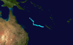
During February 7, Cyclone Harvey moved into the basin from the Australian region as a category two tropical cyclone with 10-minute windspeeds of 100 km/h (60 mph).[1][2] During the next day, Harvey gradually weakened as it moved towards the southeast, before at 1800 UTC the JTWC and TCWC Nadi reported that Harvey had weakened below tropical cyclone intensity.[2][3] The subsequent remnant low continued to move towards the south-southeast before it was last noted by TCWC Nadi on February 10, while it was located about 270 km (170 mi) to the east of New Caledonia.[1]
Unnamed Tropical Cyclone
| Category 1 tropical cyclone (Australian scale) | |||
|---|---|---|---|
| |||
| Duration | February 20 – February 24 | ||
| Peak intensity | 85 km/h (50 mph) (10-min) 987 hPa (mbar) | ||
An unnamed tropical cyclone existed from February 20 to February 24.
Tropical Cyclone Cyril
| Category 1 tropical cyclone (Australian scale) | |||
|---|---|---|---|
| Tropical storm (SSHWS) | |||
| |||
| Duration | March 16 – March 21 | ||
| Peak intensity | 85 km/h (50 mph) (10-min) 987 hPa (mbar) | ||

Cyril caused significant flooding within Fiji's Northern and Western divisions, with a peak of 5.62 m (18.4 ft) reported during March 18 within the town of Nadi, while a small storm surge of 0.3 m (0.98 ft) was observed within Nadi's bay on the same day.[4][5]
Unnamed Tropical Cyclone
| Category 1 tropical cyclone (Australian scale) | |||
|---|---|---|---|
| |||
| Duration | March 23 – March 30 | ||
| Peak intensity | 75 km/h (45 mph) (10-min) 990 hPa (mbar) | ||
Another unnamed tropical cyclone existed from March 23 to March 30.
Other systems
During January 18, Tropical Cyclone Grace moved into the basin from the Australian region, where it lost its tropical characteristics and weakened below tropical cyclone intensity.[6] The system subsequently moved westwards before it was last noted, to the south-east of New Caledonia during January 21.[6]
The remnant low of Cyclone Ingrid moved into the basin during February 25, before it was last noted by TCWC Nadi during February 27, about 400 km (250 mi) to the northeast of Brisbane Australia.[2][1]
Season effects
This table lists all the storms that developed in the South Pacific basin during the 1985–86 season. It includes their intensity on the Australian Tropical cyclone intensity scale, duration, name, areas affected, deaths, and damages.
| Name | Dates active | Peak classification | Sustained wind speeds |
Pressure | Land areas affected | Damage (USD) |
Deaths | Refs |
|---|---|---|---|---|---|---|---|---|
| Atu | December 27 – 30 | Category 1 tropical cyclone | 85 km/h (50 mph) | 987 hPa (29.15 inHg) | ||||
| Grace | January 18 – 20 | Category 1 tropical cyclone | 65 km/h (40 mph) | 997 hPa (29.45 inHg) | None | None | None | |
| Beti | February 1 – 5 | Category 1 tropical cyclone | 75 km/h (45 mph) | 990 hPa (29.24 inHg) | Vanautu | None | None | |
| Harvey | February 7 – 8 | Category 2 tropical cyclone | 100 km/h (65 mph) | 980 hPa (28.94 inHg) | New Caledonia | None | None | [2] |
| Unnamed | February 20 – 24 | Category 1 tropical cyclone | 85 km/h (50 mph) | 987 hPa (29.15 inHg) | None | None | None | |
| Cyril | March 16 – 21 | Category 1 tropical cyclone | 85 km/h (50 mph) | 987 hPa (29.15 inHg) | Fiji | |||
| Unnamed | March 23 – 30 | Category 1 tropical cyclone | 75 km/h (45 mph) | 990 hPa (29.24 inHg) | ||||
| Season Aggregates | ||||||||
| 7 systems | February 5 – May 16 | 165 km/h (105 mph) | 940 hPa (27.76 inHg) | >$100 million | 103 | |||
References
- 1 2 3 MetService (May 22, 2009). "TCWC Wellington Best Track Data 1967–2006". International Best Track Archive for Climate Stewardship.
- 1 2 3 4 Thom, Darryl E (1984). "The Australian tropical cyclone season 1983- 84" (PDF). Australian Meteorological Magazine. Australian Bureau of Meteorology. 32: 9. Retrieved December 25, 2012.
- ↑ Joint Typhoon Warning Center. "Tropical Cyclone 18P (Harvey) best track analysis". United States Navy, United States Air Force. Retrieved December 25, 2012.
- ↑ Mcgree, Simon; Yeo, Stephen W; Devi, Swastika (December 16, 2010). Flooding in the Fiji Islands between 1840 - 2009 (PDF) (Report). Risk Frontiers. p. 33. Retrieved December 31, 2012.
- ↑ Fiji Meteorological Service (August 15, 2001). List of floods occurring in the Fiji Islands between 1840 - 2000 (PDF) (Information Sheet No. 125). Pacific Disaster.net. p. 13. Retrieved December 31, 2012.
- 1 2 Severe Tropical Cyclone Grace (Report). Australian Bureau of Meteorology. Archived from the original on December 28, 2012. Retrieved March 9, 2015.
External links
- World Meteorological Organization
- Australian Bureau of Meteorology
- Fiji Meteorological Service
- Meteorological Service of New Zealand
- Joint Typhoon Warning Center