Šuica (river)
| Šuica | |
| Šujica | |
| River | |
 Šuica | |
| Country | Bosnia and Herzegovina |
|---|---|
| Region | Tropolje |
| Settlements | Šuica, Mokronoge, Letka, Kovači |
| Source | Stržanj (Veliki and Mali) |
| - location | Šuica, Bosnia and Herzegovina |
| - elevation | 1,060 m (3,478 ft) |
| - coordinates | BA 43°52′51″N 17°12′03″E / 43.880800°N 17.200720°E |
| Mouth | Buško Blato |
| - location | Prisoje, Bosnia and Herzegovina |
| - elevation | 700 m (2,297 ft) |
| - coordinates | BA 43°41′02″N 17°07′23″E / 43.683889°N 17.123039°ECoordinates: BA 43°41′02″N 17°07′23″E / 43.683889°N 17.123039°E |
| Length | 48.5 km (30 mi) |
| Basin | 730 km2 (282 sq mi) |
The River Šuica (or Šujica) is a river flowing through Duvno Field and the wider region of Tropolje in Bosnia and Herzegovina. Its sources are Veliki Stržanj and Mali Stržanj. It flows through and draines most of the Šuica Valley and Duvno Field. The river disappears underground near the village Kovači in southwestern Duvno Field and partially re-emerges at the source of Ričina in village Prisoje and then flows into the accumulation lake Buško Blato.[1]
 Veliki Stržanj
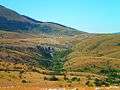 Mali Stržanj
 Šuica flowing through the woods
 the ancient bridge in Šujica
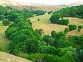 Šuica Valley
 Šuica Canyon
| Wikimedia Commons has media related to Dolina Šujice. |
References
This article is issued from Wikipedia - version of the 12/3/2016. The text is available under the Creative Commons Attribution/Share Alike but additional terms may apply for the media files.