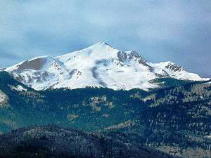
Đeravica
| Đeravica | |
|---|---|
| Gjeravica | |
 Đeravica | |
| Highest point | |
| Elevation | 2,656 m (8,714 ft) [1][2][3][4] |
| Prominence | 1,018 m (3,340 ft) [5] |
| Listing | Country high point |
| Coordinates | 42°32′1″N 20°08′24″E / 42.53361°N 20.14000°ECoordinates: 42°32′1″N 20°08′24″E / 42.53361°N 20.14000°E |
| Naming | |
| Pronunciation |
Albanian pronunciation: [ɟɛɾavitsa] Serbian: [dʑɛraʋitsa] |
| Geography | |
 Đeravica Location of Đeravica in Kosovo | |
| Location | near Deçan, Kosovo[lower-alpha 1] |
| Parent range | Prokletije |
Đeravica or Gjeravica (Albanian: Gjeravica; Serbian Cyrillic: Ђеравица) is the second highest mountain peak in the Prokletije mountain range and the Dinaric Alps chain, after Maja Jezercë. It is the highest mountain in Kosovo,[lower-alpha 1] and, according to the view held by the government of Serbia that Kosovo is part of Serbia, the highest mountain of Serbia. It has an elevation of 2,656 m (8,714 ft) above sea level.[1][2][3][4] Đeravica is located in the western part of Kosovo, in the municipality of Junik. Before 20th century, Đeravica used to be called Kaluđerovica (Kaluđer means monk in Serbian).
National importance
Đeravica is the highest mountain of Kosovo.[1] Between 1992 and 2006, it was the highest mountain peak of the Federal Republic of Yugoslavia, and then of the State Union of Serbia and Montenegro.[2] Up until the 2008 Kosovo declaration of independence, Đeravica was indisputably the highest mountain of Serbia. The Government of Serbia (supported by some other states) still considers Kosovo to be part of Serbia,[6] and according to this view, Đeravica is still the highest mountain of Serbia.[3][4]
Features
It is somewhat different from the rest of the Prokletije mountains because of the lack of a stony, limestone texture the mountains in Prokletije have. Many large and small glacial lakes can be found near the summit. The largest of the lakes is Đeravica Lake which is just under the summit and is the origin of the Erenik river.
Đeravica and the Prokletije are mostly known for the growth of Chestnuts. There are also wild strawberries growing in Đeravica during the summer.
Geography
Nearby settlements
Nearby Peaks
- Kumulore
- Tropojske Pločice
- Guri i Gjate
- Maja e Ram Arućit
- Ljogi i Prelš
Cliffs
- Biga Tamas
- Krši i Ćenit
- Kumulore
- Krši i Zi
- Guri i Mal
- Gurt e Ljove
- Brehov
- Minarja
Nearby Springs
- Kroni Tedel
- Kroni Gusija
- Kroni i Lizit
- Kroni i Nuses
- Gura e Hasanags
- Kroni i Metes
- Gura e Mir
- Kroni i Rasave
- Kroni i Smajlit
- Gura i Ćuršis
- Gura Hođs
- Kroni i Mir
Notes and references
Notes:
- 1 2 Kosovo is the subject of a territorial dispute between the Republic of Kosovo and the Republic of Serbia. The Republic of Kosovo unilaterally declared independence on 17 February 2008, but Serbia continues to claim it as part of its own sovereign territory. The two governments began to normalise relations in 2013, as part of the Brussels Agreement. Kosovo has received recognition as an independent state from 110 out of 193 United Nations member states.
References:
- 1 2 3 "CIA World Factbook 2014: Kosovo" (PDF). Central Intelligence Agency. 2014. Retrieved 5 April 2015.
- 1 2 3 "CIA World Factbook 1999". Central Intelligence Agency. 1999. Retrieved 5 April 2015.
- 1 2 3 "Facts about Serbia: Position, relief and climate". Government of Serbia. Retrieved 5 April 2015.
- 1 2 3 "Facts about Serbia". National Tourism Organisation of Serbia. 2015. Retrieved 5 April 2015.
- ↑ "Daravica, Kosovo". Peakbagger.com. Retrieved 5 April 2015.
- ↑ "Facts about Serbia: Kosovo-Metohija". Government of Serbia. Retrieved 5 April 2015.
External links
| Wikimedia Commons has media related to Đeravica. |