Erenik
| Erenik | |
|---|---|
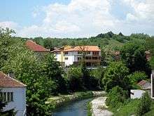 Erenik in Gjakova | |
| Country | Kosovo |
| Basin | |
| Main source | Đeravica peak, Prokletije mountains, Kosovo[lower-alpha 1] |
| River mouth | White Drin, east of Gjakova, Kosovo |
| Basin size | 516 km2 (199 sq mi) |
| Physical characteristics | |
| Length | 51 km (32 mi) |
The Erenik (Albanian: Erenik; Serbian Cyrillic: Ереник, also called Ribnik) is a river in Kosovo.[lower-alpha 1] Located in the western Kosovo, it's a 51 km (32 mi)-long right tributary to the White Drin river.
The Erenik originates near the Albanian border, in the northern slopes of the Junik mountain, a part of the Prokletije massif, under the Đeravica peak (2,656 m or 8,714 ft), the highest in Kosovo. Its origin is the Đeravica Lake just under Đeravica peak. The river flows to the south and south-east and follows the eastern edge of the Prokletije mountains, dividing them from the Western region.
Before it reaches the town of Gjakova, there is a string of settlements on the river, as the area is densely populated: the villages of Jasiċ, Nivokaz and Ponoševac, the small town of Junik and the village and mine of Babaj Boks. It receives many streams from the right, coming down from the Prokletije (most notably, Šlepica and Rečica), but the Erenik's major tributaries are from its Western side (Trava, Loćanska Bistrica).
After Gjakova, the Erenik flows next to the villages of Rača and Bistražin, emptying soon into the White Drin near the village and hill of Gradište. In the hill, the river formed a galleric epigene feature called Švanjski most. The river valley in this final section serves as a part of the route of the Peć-Gjakova-Prizren road.
The Erenik belongs to the Adriatic Sea drainage basin, drains an area of 516 km2 (199 sq mi), and it is not navigable.
See also
Notes
| Wikimedia Commons has media related to Erenik River. |
- 1 2 Kosovo is the subject of a territorial dispute between the Republic of Kosovo and the Republic of Serbia. The Republic of Kosovo unilaterally declared independence on 17 February 2008, but Serbia continues to claim it as part of its own sovereign territory. The two governments began to normalise relations in 2013, as part of the Brussels Agreement. Kosovo has received recognition as an independent state from 110 out of 193 United Nations member states.
References
- Mala Prosvetina Enciklopedija, Third edition (1985); Prosveta; ISBN 86-07-00001-2
- Jovan Đ. Marković (1990): Enciklopedijski geografski leksikon Jugoslavije; Svjetlost-Sarajevo; ISBN 86-01-02651-6
Coordinates: 42°21′51″N 20°31′36″E / 42.3641°N 20.5266°E