Årdal, Hjelmeland
| Årdal | |
|---|---|
| Village | |
|
View of the village | |
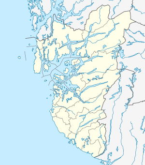 Årdal  Årdal Location in Rogaland county | |
| Coordinates: 59°09′10″N 06°09′39″E / 59.15278°N 6.16083°ECoordinates: 59°09′10″N 06°09′39″E / 59.15278°N 6.16083°E | |
| Country | Norway |
| Region | Western Norway |
| County | Rogaland |
| District | Ryfylke |
| Municipality | Hjelmeland |
| Elevation[1] | 71 m (233 ft) |
| Time zone | CET (UTC+01:00) |
| • Summer (DST) | CEST (UTC+02:00) |
| Post Code | 4137 Årdal i Ryfylke |

Årdal is a village in Hjelmeland municipality in Rogaland county, Norway. The village is located at the eastern end of the Årdalsfjorden at the mouth of the river Storåna. The village sits about 10 kilometres (6.2 mi) southeast of the village of Fister and about 12 kilometres (7.5 mi) south of the municipal centre of Hjelmelandsvågen. From 1859 until 1965, Årdal was the administrative centre of the municipality of Årdal.
Årdal's main industries are based on the mining of sand, crushed stone, and gravel. About one million tons of those items are shipped each year from the port of Årdal. The village is also home to the historic Old Årdal Church and the newer Årdal Church.[2]
References
- ↑ "Årdal, Hjelmeland (Rogaland)" (in Norwegian). yr.no. Retrieved 2016-01-19.
- ↑ Store norske leksikon. "Årdal – tettbebyggelse i Hjelmeland" (in Norwegian). Retrieved 2016-01-20.
This article is issued from Wikipedia - version of the 8/4/2016. The text is available under the Creative Commons Attribution/Share Alike but additional terms may apply for the media files.