Ryfylke
| Ryfylke | |
|---|---|
| District | |
|
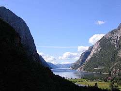
View of the Lysefjorden | |
|
Ryfylke | |
| Coordinates: 59°13′39″N 6°14′50″E / 59.2275°N 6.2472°ECoordinates: 59°13′39″N 6°14′50″E / 59.2275°N 6.2472°E | |
| Country | Norway |
| County | Rogaland |
| Region | Vestlandet |
| Area | |
| • Total | 4,546 km2 (1,755 sq mi) |
| Population (2015) | |
| • Total | 33,511 |
| • Density | 7.4/km2 (19/sq mi) |
| Demonym(s) | Ryfylkebu |
Ryfylke is a traditional district in the northeastern part of Rogaland county, Norway. The 4,546-square-kilometre (1,755 sq mi) district is located northeast of the city of Stavanger and east of the city of Haugesund and it encompasses about 60% of the county's area. It includes the mainland located northeast and east of the Boknafjorden and east of the Høgsfjorden. It also includes the islands located on the south side of the Boknafjorden. To the east, Ryfylke borders the districts of Setesdal and Sirdal, to the south is Jæren, and to the west is Haugalandet. Ryfylke is one of the 15 districts in Western Norway.[1]
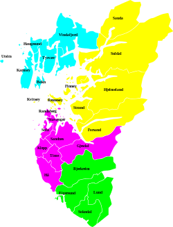
Ryfylke comprises the contemporary municipalities of Sauda, Suldal, Finnøy, Hjelmeland, Forsand, Strand, Kvitsøy, and Rennesøy. There are no large cities in Ryfylke, but there are two major towns, Sauda and Jørpeland.
Scenic attractions include the world-famous attractions of the Lysefjord with the mountain Preikestolen ("Pulpit Rock") and the mountain Kjerag. The landscape of Ryfylke is characterized by high mountains in the interior; the highest and wildest located in the north and is formed by hard, igneous rocks.[1]
Etymology
The Old Norse form of the name was Rygjafylki. The first element is the genitive plural of rygr which means "person from Rogaland" and the last element is fylke which means "county".[1]
References
- 1 2 3 Store norske leksikon. "Ryfylke" (in Norwegian). Retrieved 2016-02-10.