Águila Islet
| Native name: <span class="nickname" ">Islote Águila | |
|---|---|
 Águila Islet on Diego Ramírez Islands (last on the bottom) | |
| Geography | |
| Coordinates | 56°32′15″S 68°43′10″W / 56.53750°S 68.71944°WCoordinates: 56°32′15″S 68°43′10″W / 56.53750°S 68.71944°W |
| Archipelago | Diego Ramírez Islands |
| Adjacent bodies of water | Pacific ocean |
| Administration | |
| Region | Magallanes |
| Province | Antartica Chilena |
| Commune | Cabo de Hornos |
| Additional information | |
| NGA UFI=not listed | |
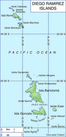
Águila Islet (Spanish: Islote Águila, "Eagle Islet") is the southernmost point of the South American continent (including the islands, but not counting the South Sandwich Islands). It is part of the larger southern group of the Diego Ramírez Islands, about 100 km (62 mi) southwest of Cape Horn in the Drake Passage.
The distance to the closest Antarctic lands (Greenwich Island, South Shetland Islands) is about 800 km (497 mi) and to the mainland (Antarctic Peninsula) is about 950 km (590 mi).
See also
- Extreme points of the Antarctic
- List of Antarctic and sub-Antarctic islands
- List of extreme points of Chile
This article is issued from Wikipedia - version of the 11/10/2016. The text is available under the Creative Commons Attribution/Share Alike but additional terms may apply for the media files.