Drake Passage


The Drake Passage (Spanish: Pasaje de Drake) or Mar de Hoces—Sea of Hoces—is the body of water between South America's Cape Horn and the South Shetland Islands of Antarctica. It connects the southwestern part of the Atlantic Ocean (Scotia Sea) with the southeastern part of the Pacific Ocean and extends into the Southern Ocean.
History
The passage receives its English-language name from the 16th-century English privateer Sir Francis Drake. Drake's only remaining ship, after having passed through the Strait of Magellan, was blown far south in September 1578. This incident implied an open connection between the Atlantic and Pacific oceans.
Half a century earlier, after a gale had pushed them south from the entrance of the Strait of Magellan, the crew of the Spanish navigator Francisco de Hoces thought they saw a land's end and possibly inferred this passage in 1525.[1] For this reason, some Spanish and Latin American historians and sources call it Mar de Hoces after Francisco de Hoces.
The first recorded voyage through the passage was that of Eendracht, captained by the Dutch navigator Willem Schouten in 1616, naming Cape Horn in the process.
Geography
The 800-kilometre (500 mi) wide passage between Cape Horn and Livingston Island is the shortest crossing from Antarctica to any other landmass. The boundary between the Atlantic and Pacific Oceans is sometimes taken to be a line drawn from Cape Horn to Snow Island (130 kilometres (81 mi) north of mainland Antarctica). Alternatively, the meridian that passes through Cape Horn may be taken as the boundary. Both boundaries lie entirely within the Drake Passage.
The other two passages around the extreme southern part of South America (though not going around Cape Horn as such), Strait of Magellan and Beagle Channel, are very narrow, leaving little room for a ship. They can also become icebound, and sometimes the wind blows so strongly no sailing vessel can make headway against it. Hence most sailing ships preferred the Drake Passage, which is open water for hundreds of miles, despite very rough conditions. The small Diego Ramírez Islands lie about 100 kilometres (62 mi) south-southwest of Cape Horn.
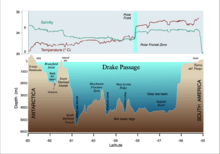
There is no significant land anywhere around the world at the latitudes of Drake Passage, which is important to the unimpeded flow of the Antarctic Circumpolar Current which carries a huge volume of water (about 600 times the flow of the Amazon River) through the Passage and around Antarctica.
Ships in the Passage are often good platforms for the sighting of whales, dolphins and seabirds including giant petrels, other petrels, albatrosses and penguins.
Geology
The passage is known to have been closed until around 41 million years ago[2] according to a chemical study of fish teeth found in oceanic sedimentary rock. Before the passage opened, the Atlantic and Pacific Oceans were separated entirely with Antarctica being much warmer and having no ice cap. The joining of the two great oceans started the Antarctic Circumpolar Current and cooled the continent significantly.
Gallery
 Rough seas are common in the Drake Passage
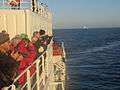 Tourists watch whales in the Drake Passage
 Light-mantled sooty albatross flying over the Drake Passage
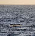 Humpback whales are a common sight in the Drake Passage
 Hourglass dolphins leaping in the Passage
 Drake Passage or Mar de Hoces between South America and Antarctica
 Drake Passage
See also
- Francis Drake
- García de Nodal
- Strait of Magellan
- Beagle Channel
- Bransfield Strait
- Sars Bank
- Elizabeth Island
References
- ↑ Oyarzun, Javier, Expediciones españolas al Estrecho de Magallanes y Tierra de Fuego, 1976, Madrid: Ediciones Cultura Hispánica ISBN 84-7232-130-4
- ↑ Helen Briggs (21 April 2006). "Fossil gives clue to big chill". BBC News. Retrieved 1 November 2007.
External links
![]() Media related to Drake Passage at Wikimedia Commons
Media related to Drake Passage at Wikimedia Commons
- National Oceanography Centre, Southampton page of the important and complex bathymetry of the Passage
- A NASA image of an eddy in the Passage
- Larger-scale images of the passage from the US Navy (Rain, ice edge and wind images)
Coordinates: 58°34′49″S 65°54′34″W / 58.58028°S 65.90944°W