Civic administration of Kolkata
The civic administration of Kolkata (the metropolitan city and the capital of the West Bengal state of India) is executed by several government agencies, and consists of overlapping structural divisions. Kolkata's administrative agencies have areas of jurisdiction that do not coincide.
Governing bodies
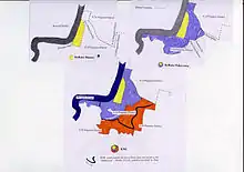
At least five administrative definitions of the city are available, many of which overlap each other. The paradoxical nature of a municipal area officially being a subset of one district despite being larger in area than the district itself is mostly attributed to government reluctance to streamline the administration, and the fact that Kolkata's gradual urban sprawl is not only a result of economic development and demographic growth due to incoming migrants from other states. It is also a product of millions of Hindu refugees settling in fits and starts across the city, during multiple bouts of violence in the region, and especially in 1947 and 1971. Listed in ascending order of area, the broad administrative definitions of the city are :
Kolkata District
Headed by the District Collector for Kolkata district, it primarily includes the historic core and downtown parts of the city. It functions as an administrative unit for revenue, national and central policymaking and census enumeration purposes.
Kolkata Municipal Corporation (KMC)
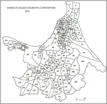
The relatively larger area of the city's main administrative body, the KMC, is the one most widely understood to be what constitutes ("Kolkata or Kolkata City"). Its 144 municipal wards span the entirety of the city's core area under the Kolkata District, as well as areas under the administration of South 24 Parganas district such as (Behala, Kudghat, Jadavpur, Garia), among others.
The KMC oversees and manages the civic infrastructure of the city's 15 boroughs, which together encompass 144 wards.[1] Each ward elects a councillor to the KMC. Each borough has a committee of councillors, each of whom is elected to represent a ward. By means of the borough committees, the corporation undertakes urban planning and maintains roads, government-aided schools, hospitals, and municipal markets.[2] As Kolkata's apex body, the corporation discharges its functions through the mayor-in-council, which comprises a mayor, a deputy mayor, and ten other elected members of the KMC.[3] The functions of the KMC include water supply, drainage and sewerage, sanitation, solid waste management, street lighting, and building regulation.[2]
Kolkata Police
Since 2 September 2011, the area under the jurisdiction of Kolkata Police has remained co-terminus with the KMC area.[4]
Greater Kolkata
A non-legal term with no fixed boundaries, it is used colloquially by citizens and enjoys wide recognition in conversations, advertisements and addresses, being firmly embedded in the city's social fabric. Historically, it has always broadly composed of the KMC area and other urban localities situated just adjacent to it. To the north, some of these localities are, from west to east: North Barrackpur, Barrackpore, Titagarh, Khardaha, Panihati, Kamarhati, Baranagar, New Barrackpore, Madhyamgram, Barasat, Dum Dum, North Dum Dum, South Dum Dum and Bidhannagar. To the south, these are from west to east: Maheshtala, Budge Budge, Pujali, Rajpur Sonarpur and Baruipur. Many of these have municipality status.
Kolkata Metropolitan Area
According to the 2011 Census of India, the much larger Kolkata Metropolitan Area is the third-largest urban agglomeration in India. It is spread across the districts of North 24 Parganas, South 24 Parganas, Nadia, Hooghly and Howrah, with nearly 2 crore residents. The Kolkata Metropolitan Development Authority (KMDA), another ancillary civic body, is responsible for the statutory planning and development of this mega urban area.[5] The KMA includes a large suburban hinterland around the urban centres of Kolkata.
The city also has an apolitical titular post, that of the Sheriff of Kolkata.[6] The Sheriff presides over various city-related functions and conferences.
State government
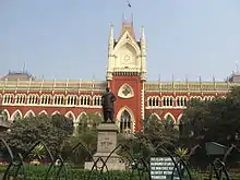
As the capital of the state and the seat of the Government of West Bengal, Kolkata houses not only the various offices of local government listed above, but also, for the state level, the West Bengal Legislative Assembly, the Secretariat (Writers' Building) and the Calcutta High Court. Kolkata also has lower courts; the Small Causes Court for civil matters, and the Sessions Court for criminal cases.
Assembly and parliamentary constituencies

The parliamentary constituencies and assembly constituencies in West Bengal, as defined by Election Commission of India, underwent delimitation in 2008 according to the report of the Delimitation Commission.[7] Kolkata district is divided into 16 assembly constituencies (and partially 1 more also) — Kashipur-Belgachhia, Maniktala, Shyampukur, Jorasanko, Beleghata, Entally, Chowringhee, Kolkata Port, Metiaburuz (partially), Bhabanipur, Ballygunge, Rashbehari, Kasba, Behala Purba, Behala Paschim, Tollyganj and Jadavpur. There are two parliamentary constituencies — Kolkata North and Kolkata South — that have the name "Kolkata" associated with them. Chowringhee, Entally, Beliaghata, Jorasanko, Shyampukur, Maniktala and Kashipur-Belgachhia assembly constituencies form Kolkata Uttar (Lok Sabha constituency). Kolkata Port, Bhabanipur, Ballygunge, Rashbehari, Kasba, Behala Purba and Behala Paschim assembly constituencies form Kolkata Dakshin (Lok Sabha constituency).[7]
Jadavpur and Tollyganj assembly constituencies are within Jadavpur parliamentary constituency. Few wards (Ward no 136 to 141) of Kolkata Municipal Corporation (Kolkata district) area constitute part of Metiaburuz (Vidhan Sabha constituency). Metiaburuz assembly constituency also has wards from Maheshtala Municipality of South 24 Parganas District. Metiaburuz assembly constituency lies within Diamond Harbour parliamentary constituency.[7]
References
- "Basic statistics of Kolkata". Kolkata Municipal Corporation. Retrieved 5 February 2012.
- "KMC functions". Kolkata Municipal Corporation. Retrieved 3 December 2011.
- "Legislative structure" (PDF). Kolkata Municipal Corporation. Archived from the original (PDF) on 4 January 2012. Retrieved 3 December 2011.
- "Change of guard brings welcome relief". Times of India. 2 September 2011. Archived from the original on 7 July 2012. Retrieved 10 December 2011.
- "About Kolkata Metropolitan Development Authority". Kolkata Metropolitan Development Authority. Archived from the original on 28 September 2007. Retrieved 1 September 2007.
- "New sheriff of Kolkata". The Telegraph. 28 December 2005. Retrieved 1 September 2007.
- Delimitation Commission (15 February 2006). "Notification: order no. 18" (PDF). New Delhi: Election Commission of India. pp. 12–25. Archived from the original (PDF) on 18 September 2010. Retrieved 11 February 2012.