New Creek Mountain
| New Creek Mountain | |
|---|---|
| Highest point | |
| Elevation | 3,084 ft (940 m) NAVD 88[1] |
| Coordinates | 39°13′40.91″N 79°07′43.59″W / 39.2280306°N 79.1287750°WCoordinates: 39°13′40.91″N 79°07′43.59″W / 39.2280306°N 79.1287750°W [1] |
| Geography | |
| Location | Grant / Mineral counties, West Virginia, U.S. |
| Parent range | Ridge-and-Valley Appalachians |
| Topo map | USGS Greenland Gap |
| Climbing | |
| Easiest route | Hike |
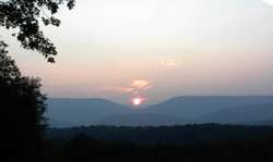
Saddle Mountain, part of New Creek Mountain, as viewed at sunrise from Skyline on U.S. Route 50 in West Virginia
New Creek Mountain is a mountain ridge of the Ridge-and-Valley Appalachians in Grant and Mineral counties in the U.S. state of West Virginia. The mountain is named for New Creek which rises and flows along its western flanks. It is part of the Wills Mountain Anticline, with Knobly Mountain along its eastern flank. The Allegheny Front rises steeply to the west of New Creek Mountain. Oriskany (Ridgeley) sandstone cliffs ring the entire mountain.
Saddle Mountain, prominent in the view eastward from the Skyland Overlook on U.S. 50, is a saddle-shaped dip in the mountain's ridgecrest.
The New Creek Mountain Cliffs are 800 feet (240 m) high, lining a great cleft in the mountain that rivals the famed Franconia Notch of New England.
References
- 1 2 "Evans". NGS data sheet. U.S. National Geodetic Survey. Retrieved 2008-12-06.
External links
- "New Creek Mountain". Geographic Names Information System. United States Geological Survey. Retrieved 2008-12-06.
- "New Creek Mountain". Peakbagger.com. Retrieved 2008-12-06.
This article is issued from Wikipedia - version of the 5/1/2016. The text is available under the Creative Commons Attribution/Share Alike but additional terms may apply for the media files.