Marianna/Lee County Airport
| Marianna/Lee County Airport Steve Edwards Field | |||||||||||
|---|---|---|---|---|---|---|---|---|---|---|---|
 | |||||||||||
| IATA: none – ICAO: none – FAA LID: 6M7 | |||||||||||
| Summary | |||||||||||
| Airport type | Public | ||||||||||
| Owner | City of Marianna | ||||||||||
| Serves | Marianna, Arkansas | ||||||||||
| Elevation AMSL | 219 ft / 67 m | ||||||||||
| Coordinates | 34°46′58″N 090°48′36″W / 34.78278°N 90.81000°WCoordinates: 34°46′58″N 090°48′36″W / 34.78278°N 90.81000°W | ||||||||||
| Map | |||||||||||
 6M7 Location of airport in Arkansas | |||||||||||
| Runways | |||||||||||
| |||||||||||
| Statistics (2012) | |||||||||||
| |||||||||||
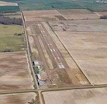
Marianna/Lee County Airport (FAA LID: 6M7), also known as Steve Edwards Field, is a public use airport in Lee County, Arkansas, United States.[1] It is owned by the City of Marianna and located three nautical miles (6 km) west of its central business district.[1] This airport is included in the National Plan of Integrated Airport Systems for 2011–2015, which categorized it as a general aviation facility.[2]
Facilities and aircraft
Marianna/Lee County Airport covers an area of 55 acres (22 ha) at an elevation of 219 feet (67 m) above mean sea level. It has one runway designated 18/36 with an asphalt surface measuring 4,021 by 75 feet (1,226 x 23 m).[1]
For the 12-month period ending July 31, 2012, the airport had 25,050 aircraft operations, an average of 68 per day: 99.8% general aviation and 0.2% military. At that time there were six aircraft based at this airport: 83% single-engine and 17% helicopter.[1]
See also
References
- 1 2 3 4 5 FAA Airport Master Record for 6M7 (Form 5010 PDF). Federal Aviation Administration. Effective November 15, 2012.
- ↑ "2011–2015 NPIAS Report, Appendix A" (PDF, 2.03 MB). National Plan of Integrated Airport Systems. Federal Aviation Administration. October 4, 2010. External link in
|work=(help)
External links
- Aerial image as of January 2001 from USGS The National Map
- FAA Terminal Procedures for 6M7, effective December 8, 2016
- Resources for this airport:
- FAA airport information for 6M7
- AirNav airport information for 6M7
- FlightAware airport information and live flight tracker
- SkyVector aeronautical chart for 6M7