Lykketoppen
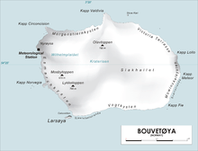
Map of Bouvetøya
Lykketoppen,[1][2] occasionally anglicized as Lykke Peak, is a snow-covered, 765-meter (2,510 ft) tall summit that surmounts the southwest part of Bouvetøya, standing 1 nautical mile (2 km) east of Norvegia Point. It was first roughly charted in 1898 by a German expedition under Carl Chun, and was recharted and named in December 1927 by the First Norvegia Expedition under Captain Harald Horntvedt.[3]
References
- ↑ "Lykketoppen". Norwegian Polar Institute. Archived from the original on 11 May 2012. Retrieved 11 May 2012.
- ↑ Barr, Susan (1987). Norway's Polar Territories. Oslo: Aschehoug. p. 59. ISBN 82-03-15689-4.
- ↑ "Lykke Peak". Geographic Names Information System. Archived from the original on 12 May 2012. Retrieved 12 May 2012.
Coordinates: 54°27′S 3°23′E / 54.450°S 3.383°E
![]() This article incorporates public domain material from the United States Geological Survey document "Lykke Peak" (content from the Geographic Names Information System).
This article incorporates public domain material from the United States Geological Survey document "Lykke Peak" (content from the Geographic Names Information System).
This article is issued from Wikipedia - version of the 10/31/2016. The text is available under the Creative Commons Attribution/Share Alike but additional terms may apply for the media files.