Lake Tomahawk (CDP), Wisconsin
| Lake Tomahawk, Wisconsin | |
|---|---|
| Census-designated place | |
 Lake Tomahawk, Wisconsin | |
| Coordinates: 45°48′51″N 89°35′38″W / 45.81417°N 89.59389°WCoordinates: 45°48′51″N 89°35′38″W / 45.81417°N 89.59389°W | |
| Country | United States |
| State | Wisconsin |
| County | Oneida |
| Area | |
| • Total | 1.649 sq mi (4.27 km2) |
| • Land | 1.537 sq mi (3.98 km2) |
| • Water | 0.112 sq mi (0.29 km2) |
| Elevation | 1,640 ft (500 m) |
| Population (2010) | |
| • Total | 228 |
| • Density | 140/sq mi (53/km2) |
| Time zone | Central (CST) (UTC-6) |
| • Summer (DST) | CDT (UTC-5) |
| ZIP code | 54539 |
| Area code(s) | 715 & 534 |
| GNIS feature ID | 1567755[1] |
Lake Tomahawk is an unincorporated census-designated place located in the town of Lake Tomahawk, Oneida County, Wisconsin, United States. Lake Tomahawk is located on Wisconsin Highway 47 15 miles (24 km) northwest of Rhinelander. Lake Tomahawk has a post office with ZIP code 54539.[2] As of the 2010 census, its population was 228.[3]
History
Lake Tomahawk was originally called Tomahawk Lake, and under the latter name was platted in 1892.[4] The community took its name from nearby Tomahawk Lake.[5] The name of the post office was changed from Tomahawk Lake to Lake Tomahawk in 1928.[6]
References
- ↑ U.S. Geological Survey Geographic Names Information System: Lake Tomahawk (CDP), Wisconsin
- ↑ ZIP Code Lookup
- ↑ "American FactFinder". U.S. Census Bureau. Retrieved 12 April 2011.
- ↑ Chicago and North Western Railway Company (1908). A History of the Origin of the Place Names Connected with the Chicago & North Western and Chicago, St. Paul, Minneapolis & Omaha Railways. p. 131.
- ↑ Chicago and North Western Railway Company (1908). A History of the Origin of the Place Names Connected with the Chicago & North Western and Chicago, St. Paul, Minneapolis & Omaha Railways. p. 131.
- ↑ "Oneida County". Jim Forte Postal History. Retrieved 30 March 2015.
Municipalities and communities of Oneida County, Wisconsin, United States | ||
|---|---|---|
| City | 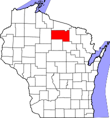 | |
| Towns | ||
| CDPs | ||
| Unincorporated communities | ||
| Ghost town | ||
| Footnotes | ‡This populated place also has portions in an adjacent county or counties | |
This article is issued from Wikipedia - version of the 10/22/2016. The text is available under the Creative Commons Attribution/Share Alike but additional terms may apply for the media files.