Gaston's Airport
| Gaston's Airport | |||||||||||
|---|---|---|---|---|---|---|---|---|---|---|---|
 | |||||||||||
| IATA: none – ICAO: none – FAA LID: 3M0 | |||||||||||
| Summary | |||||||||||
| Airport type | Public use | ||||||||||
| Owner | Gaston's White River Resort | ||||||||||
| Serves | Lakeview, Arkansas | ||||||||||
| Elevation AMSL | 479 ft / 146 m | ||||||||||
| Coordinates | 36°20′57″N 092°33′21″W / 36.34917°N 92.55583°WCoordinates: 36°20′57″N 092°33′21″W / 36.34917°N 92.55583°W | ||||||||||
| Website | www.gastons.com/... | ||||||||||
| Map | |||||||||||
 3M0 Location of airport in Arkansas | |||||||||||
| Runways | |||||||||||
| |||||||||||
| Statistics (2010) | |||||||||||
| |||||||||||
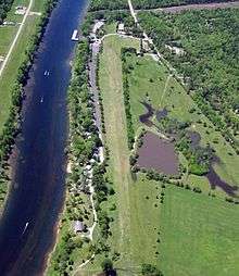
Gaston's Airport (FAA LID: 3M0) is a public use airport located one nautical mile (2 km) south of the central business district of Lakeview, a city in Baxter County, Arkansas, United States.[1] It is privately owned by Gaston's White River Resort[1] and is also known as Gaston's White River Resort Airstrip.[2]
Facilities and aircraft
Gaston's Airport covers an area of 16 acres (6 ha) at an elevation of 479 feet (146 m) above mean sea level. It has one runway designated 6/24 with a turf surface measuring 3,200 by 55 feet (975 x 17 m).[1]
For the 12-month period ending May 31, 2010, the airport had 10,700 aircraft operations, an average of 29 per day: 98% general aviation and 2% military.[1]
References
- 1 2 3 4 5 FAA Airport Master Record for 3M0 (Form 5010 PDF). Federal Aviation Administration. Effective November 15, 2012.
- ↑ "Gaston's White River Resort Airstrip (3M0)". Gaston's White River Resort.
External links
- Gaston's White River Resort Airstrip (3M0)
- Gaston's Resort (3M0) at Arkansas Department of Aeronautics
- Aerial image as of January 2002 from USGS The National Map
- Airfield photos from U.S. Civil Air Patrol at the Wayback Machine (archived September 23, 2006)
- Resources for this airport:
- FAA airport information for 3M0
- AirNav airport information for 3M0
- FlightAware airport information and live flight tracker
- SkyVector aeronautical chart for 3M0
This article is issued from Wikipedia - version of the 11/14/2016. The text is available under the Creative Commons Attribution/Share Alike but additional terms may apply for the media files.