Zushi, Kanagawa
| Zushi 逗子市 | |||
|---|---|---|---|
| City | |||
|
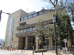
Zushi City Hall | |||
| |||
 Location of Zushi in Kanagawa Prefecture | |||
 Zushi
| |||
| Coordinates: 35°17′N 139°35′E / 35.283°N 139.583°ECoordinates: 35°17′N 139°35′E / 35.283°N 139.583°E | |||
| Country | Japan | ||
| Region | Kantō | ||
| Prefecture | Kanagawa Prefecture | ||
| Government | |||
| • Mayor | Ryuichi Hirayama (since December 2006) | ||
| Area | |||
| • Total | 17.34 km2 (6.70 sq mi) | ||
| Population (June 1, 2012) | |||
| • Total | 58,087 | ||
| • Density | 3,350/km2 (8,700/sq mi) | ||
| Time zone | Japan Standard Time (UTC+9) | ||
| - Tree | Camellia | ||
| - Flower | Tricyrtis hirta | ||
| Address | 5-2-16 Zushi, Zushi-shi, Kanagawa-ken 249-8686 | ||
| Website |
www | ||


Zushi (逗子市 Zushi-shi) is a city located in Kanagawa Prefecture, Japan.
As of June 2012, the city has an estimated population of 58,087 and a population density of 3,350 per km². The total area is 17.34 km2 (6.70 sq mi).
Geography
Zushi is located at the head of Miura Peninsula, facing Sagami Bay on the Pacific Ocean. The city is built on an alluvial plain formed by the Tagoe River (田越川) and surrounded by low, steep hills.[1]
Surrounding municipalities
History
The area of Zushi has been inhabited since prehistoric times, and numerous Kofun period and Yayoi period remains have been discovered. During the Heian period, it came under the control of the Miura clan, and during the Kamakura period formed part of the outer fortifications for Kamakura. The port of Kotsubo is mentioned frequently in the Azuma Kagami. The name 'Zushi' has been written in many different ways, including 豆師・図師・厨子・豆子.[1] The term "zushi" itself means a street, an alley or an intersection and came to the Kantō region from Kyoto.[1] One of its first appearances is in a Hōjō clan document as 豆師. During the Edo period, along with most of eastern Sagami Province, the area was tenryō territory under direct control of the Tokugawa shogunate, and administered by various hatamoto.
In the April 1, 1889, cadastral reform after the Meiji Restoration, Tagoe Village within Miura District Kanagawa Prefecture was created through the merger of six local hamlets. Development of the area was encouraged by the opening of the Yokosuka Line railway on June 16, 1889. Tagoe Village changed its name to Zushi Village on April 1, 1924; however, on April 1, 1943 it was annexed by Yokusuka city. Zushi regained its status as an independent municipality on July 1, 1952, as Zushi Town. City status was gained on April 15, 1954. Zushi developed as a resort area in the 1960s, with the opening of Zushi Marina in 1967. In the mid-1990s, the city was the center of a political controversy involving the creation of a housing area for the United States Navy at Ikego, the site of a former Imperial Japanese Navy ammunition depot, to support the expansion of nearby Yokosuka Naval Base.
Government and politics
Economy
Zushi is a popular beach resort, and has attracted many famous writers (e.g. Roka Tokutomi), media personalities (e.g. Yujiro Ishihara and Mino Monta), musicians and politicians (e.g. Shintaro Ishihara) as either a residence or location for a second home. The city is largely a bedroom community for Tokyo and Yokohama.
Transportation
Rail
Highways
Local attractions

- Ganden-ji, number two of the Bandō Sanjūsankasho
- Hosshō-ji, Nichiren-sect temple that is supposed to lie on the spot where Nichiren was rescued from a mob by three white monkeys.
International relations
Twin towns — Sister cities
Zushi is twinned with:
-
 Ikaho, Gunma, Japan (1979)
 -
 Nazaré, Portugal (2004)
Notable people from Zushi
- Takeshi Aikoh - professional baseball player
- Nobuteru Ishihara - politician
- Hirotaka Ishihara - politician
- Risako Sugaya - singer
- Kaori Yoneyama - professional wrestler
References
External links
| Wikivoyage has a travel guide for Zushi. |
| Wikimedia Commons has media related to Zushi, Kanagawa. |
- Zushi City official website (Japanese)
- Zushi's History (Japanese)
| Wards of Yokohama | ||
|---|---|---|
| Wards of Kawasaki | ||
| Wards of Sagamihara | ||
| Core city | ||
| Special cities | ||
| Cities | ||
| Aikō District | ||
| Ashigarakami District | ||
| Ashigarashimo District | ||
| Kōza District | ||
| Miura District | ||
| Naka District | ||