Zhoushan


![]() Zhoushan , formerly romanized as Chusan, is a prefecture-level "city"[lower-alpha 2] in northeastern Zhejiang Province in eastern China. It consists of an archipelago of islands at the southern mouth of Hangzhou Bay, off Ningbo. The prefecture's city proper is Dinghai on Zhoushan Island, now administered as the prefecture's Dinghai District. During the 2010 census, Zhoushan Prefecture's population was 1,121,261, out of whom 842,989 lived in the urban districts of Dinghai and Putuo.
Zhoushan , formerly romanized as Chusan, is a prefecture-level "city"[lower-alpha 2] in northeastern Zhejiang Province in eastern China. It consists of an archipelago of islands at the southern mouth of Hangzhou Bay, off Ningbo. The prefecture's city proper is Dinghai on Zhoushan Island, now administered as the prefecture's Dinghai District. During the 2010 census, Zhoushan Prefecture's population was 1,121,261, out of whom 842,989 lived in the urban districts of Dinghai and Putuo.
On 8 July 2011 the central government approved Zhoushan as Zhoushan Archipelago New Area, a state-level new area.
History


The archipelago was inhabited 6,000 years ago during the Neolithic by people of the Hemudu culture. During the Spring and Autumn period, Zhoushan was called Yongdong, referring to its location east of the Yong River. At the time, it belonged to the state of Yue. The fishermen and sailors who inhabited the islands often engaged in piracy and became recruits for uprisings against the central authorities. At the time of the Eastern Jin, the Zhoushan Islands served as the base for Sun En's rebellion. Sun En, an adherent of the Taoist sect the Way of the Five Pecks of Rice, launched his rebellion around the year 400 and was defeated by Jin forces in 402.[3] Today's Zhoushan was first created as Wengshan County in Ming Prefecture in 738 under the Tang.
In 863, the Japanese Buddhist monk Egaku (慧锷)[4] and a Putuoshan local Zhang-shi (张氏) placed a statue of Guanyin at Chaoyin Cave (潮音洞) that would later become a popular tourist and pilgrim destination. In 1073, under the Song, it was renamed Changguo County; this was upgraded to a prefecture in the early Yuan dynasty.During the Ming dynasty, especially between the years 1530 and 1560, Japanese and Chinese pirates used Zhoushan as one of their principal bases from which they launched attacks as far as Nanjing; "the whole Chinese coast from northern Shandong to western Guangdong was ravaged to a distance of sixty miles inland."[5]
After suppression of the pirates, Zhoushan became an important commercial entrepôt. Under the early Qing dynasty, it played a similar role to Xiamen and Guangzhou as a frequent port of call for Western traders.[6] Changguo Prefecture became Dinghai County within Zhejiang Province in 1688 under the Qing. The restriction of all European trade to the port of Guangzhou in 1760 forced Westerners to leave Zhoushan. One of the requests of Lord Macartney's embassy to the Qianlong Emperor in 1793 was an acquisition of "a small unfortified island near Zhoushan for the residence of English traders, storage of goods, and outfitting of ships." The Qianlong Emperor denied this request together with all the rest.[7]
British forces under Captain Charles Elliot captured Zhoushan on 5–6 July 1840 during the First Opium War and evacuated it in early 1841, after Elliot reached an agreement with Qishan, the Governor-General of Tianjin and Grand Secretary to the Daoguang Emperor, in exchange for cession of Hong Kong.[8] At that time, Zhoushan was a well known port while Hong Kong was still only a fishing village. The British Foreign Secretary Palmerston was famously livid when he learned that Elliot agreed to the cession of Hong Kong ("a barren island with hardly a house on it") while giving up Zhoushan. Elliot was dismissed in April 1841 for his blunder.[9] His replacement Sir Henry Pottinger led a British fleet that recaptured Zhoushan on 1 October 1841.[10] The First Opium War ended with conclusion of the Treaty of Nanjing in which China opened up the cities of Guangzhou ("Canton"), Fuzhou ("Foochow"), Xiamen ("Amoy"), Ningbo ("Ningpo"), and Shanghai to residence by British subjects for the purpose of trade. As a result, Britain no longer had any use for Zhoushan but it kept the island until 1846 as a guarantee for the fulfilment of the stipulations of the treaty.[11] Dinghai was upgraded to a directly-controlled subprefecture (定海直隸廳) sometime in 1841.
Zhoushan was also occupied by the British in 1860 during the Second Opium War. Wang Yijun, a leader of the Taiping rebels, attempted to retake Zhoushan from its Qing garrison on 13 February 1862 but was defeated and killed.
Following the Xinhai Revolution and the establishment of the Republic of China, Dinghai Subprefecture reverted to a county. Sun Yat-sen visited Zhoushan on 25 August 1916 and wrote Travelling to Putuo (游普陀志奇, You Putuo Zhiqi). On 1 October 1942, the Japanese ship Lisbon Maru was transporting 1,800 POWs to Tokyo when she was attacked by the USS Grouper off Qingbing (青浜) or Dongfu; one torpedo hit and she sank the next day. The fishermen of nearby Dongji (东极乡) rescued 384 of the British prisoners from the wreckage. Amid the Chinese Civil War, Dinghai County lost Shengsi, which became an Archipelago Directly-controlled District (列島直屬區) of Jiangsu in 1946, then a separate county in October 1949. The same year, Dinghai County was divided into Dinghai and Wengzhou (翁洲) Counties.
Zhoushan was overrun by the Communists on 17 May 1950. Wengzhou was merged back into Dinghai County, which made up part of Ningbo Prefecture, and Shengsi made up a special area (特区) and then county of the Songjiang Prefecture, then still part of Jiangsu. In March 1953, the Council of Ministers opted to establish the Zhoushan Prefecture, returning Shengsi and dividing Dinghai into Dinghai, Putuo, and Daishan. Ningbo's Xiangshan County was also briefly incorporated into this new prefecture from 1954 to 1958. From 1958 to May 1962, Zhoushan was incorporated into Ningbo before becoming a separate prefecture again. Shengsi was temporarily assigned to Shanghai in the early 1960s. The short-lived Daqu County (大衢縣) was created in 1962 before being redivided between Daishan and Shengsi four years later.
Zhoushan was promoted to a prefecture-level "city" on 27 January 1987, with Dinghai and Putuo Counties upgraded to districts. The municipal People's Government was established on 8 March of that year. April of the same year, the ports of Zhoushan became open to foreign ships. On 10 April 1988, it became a coastal economic open zone.
Administration
The prefecture-level city of Zhoushan administers two districts and two counties. These are further divided into 45 township-level divisions, including 24 towns, 12 townships and 9 subdistricts. In 2013, Zhoushan modified its administrative divisions to a total of 35 township-level divisions, including 17 towns, 5 townships and 13 subdistricts. Detailed divisions are listed as follows.
| Map | ||||
|---|---|---|---|---|
| Subdivision | Hanzi | Pinyin | Population (2010) | Terrestrial Area (km2) |
| Dinghai District | 定海区 | Dìnghǎi Qū | 464,184 | 568.8 |
| Putuo District | 普陀区 | Pǔtuó Qū | 378,805 | 458.6 |
| Daishan County | 岱山县 | Dàishān Xiàn | 202,164 | 326.5 |
| Shengsi County | 嵊泗县 | Shèngsì Xiàn | 76,108 | 86 |

- Dinghai District (12 divisions, 9 sub-districts and 3 towns)
- Jiefang Sub-district (解放街道)
- Changguo Sub-district (昌国街道), Huannan Sub-district (環南街道), Chengdong Sub-district (城東街道), Yancang Sub-district (盐倉街道), Lincheng Sub-district (临城街道), Xiaosha Sub-district (小沙街道), Ma'ao Sub-district (馬岙街道), Cengang Sub-district (岑港街道), Baiquan Town (白泉镇), Jintang Town (金塘镇)and Ganlan Town (干揽鎮)
- Putuo District (9 divisions, 4 sub-districts and 5 towns)
- Shenjiamen Sub-district (沈家门街道), Donggang Sub-district (东港街道), Zhanmao Sub-district (展茅街道), Zhujiajian Sub-district (朱家尖街道), Putuoshan Town (普陀山镇), Dongji Town (东极镇), Taohua Town (桃花镇), Xiazhi Town (蝦峙镇) and Liuheng Town (六橫鎮)
- Daishan County (7 divisions, 6 towns and 1 township)
- Gaoting Town (高亭鎮), Qushan Town (衢山鎮), Changtu Town (長涂鎮), Dongsha Town (東沙鎮), Daidong Town (岱東鎮), Daixi Town (岱西鎮)and Xiushan Township (秀山鄉)
- Shengsi County (7 divisions, 4 towns and 3 townships)
- Caiyuan Town (菜園鎮), Yangshan Town (洋山鎮), Shengshan Town (嵊山鎮), Wulong Township (五龍鄉), Huanglong Township (黃龍鄉), Gouqi Township (枸杞鄉) and Huaniao Township (花鳥鄉)
Geography
The Zhoushan Archipelago, comprising 1,390 islands and 3,306 reefs, is located outside of Hangzhou Bay. It is the largest archipelago of China. Among these islands, 103 are inhabited all year round, 58 are larger than one square kilometer, and only 12 have populations over 10,000. Below is a list of major inhabited islands.


(DH = Dinghai District, PT = Putuo District, DS = Daishan County, SS = Shengsi County)
There are 6 Major Large Islands (over 50 km2 (19 sq mi)):
- Zhoushan Island (舟山岛), 502.65 km2 (194.07 sq mi), 635,595, (DH/PT)
- Daishan Island (岱山岛), 119.32 km2 (46.07 sq mi), 111,765, (DS)
- Liuheng Island (六横岛), 109.40 km2 (42.24 sq mi), 59,102, (PT)
- Jintang Island (金塘岛), 82.11 km2 (31.70 sq mi), 37,321, (DH)
- Zhujiajian Island (朱家尖岛), 75.84 km2 (29.28 sq mi), 27,981, (PT)
- Qushan Island (衢山岛/大衢岛), 73.57 km2 (28.41 sq mi), 53,016, (DS)
There are 11 Middle-sized Islands (between 10 and 50 km2 (3.9 and 19.3 sq mi)):
- Taohua Island (桃花岛), 44.43 km2 (17.15 sq mi), 10,867, (PT)
- Greater Changtu Island (大长涂山), 40.62 km2 (15.68 sq mi), 1,750, (DS)
- Xiushan Island (秀山岛), 26.33 km2 (10.17 sq mi), 10,106, (DS)
- Sijiao Island (泗礁山), 25.88 km2 (9.99 sq mi), 39,008, (SS)
- Xiazhi Island (虾峙岛), 18.59 km2 (7.18 sq mi), 11,247, (PT)
- Dengbu Island (登步岛), 16.72 km2 (6.46 sq mi), 2,479, (PT)
- Mount Putuo (普陀山), 16.06 km2 (6.20 sq mi), 10,337, (PT)
- Cezi Island (册子岛), 14.97 km2 (5.78 sq mi), 6,334, (DH)
- Changbai Island (长白岛), 14.16 km2 (5.47 sq mi), 3,066, (DH)
- Lesser Changtu Island (小长涂山), 13.33 km2 (5.15 sq mi), 19,750, (DS)
- Dayu Island (大鱼山), 11.03 km2 (4.26 sq mi), 788, (DS)
There are 10 islands between 5 and 10 km2 (1.9 and 3.9 sq mi):
- Fuodu Island (佛渡岛), 9.19 km2 (3.55 sq mi), 1,292, (PT)
- Yuanshan Island (元山岛/悬山岛), 8.21 km2 (3.17 sq mi), 751, (PT)
- Changzhi Island (长峙岛), 7.97 km2 (3.08 sq mi), 3,464, (DH)
- Damao Island (大猫岛), 6.92 km2 (2.67 sq mi), 453, (DH)
- Greater Yangshan Island (大洋山), 6.56 km2 (2.53 sq mi), 9,336, (SS)
- Gouqi Island (枸杞岛), 6.38 km2 (2.46 sq mi), 7,611, (SS)
- Dapeng Island (大鹏岛), 6.09 km2 (2.35 sq mi), 785, (DH)
- Aoshan Island (岙山), 5.96 km2 (2.30 sq mi), 1,087, (DH)
- Greater Huanglong Island (大黄龙岛), 5.67 km2 (2.19 sq mi), 6,910, (SS)
- Xiaogan Island (小干岛), 5.56 km2 (2.15 sq mi), 5,248, (PT)
Small Major Inhabited Islands:
- Shengshan Island (嵊山岛), 4.47 km2 (1.73 sq mi), 8,309, (SS)
- Shulanghu Island (鼠浪湖岛), 4.38 km2 (1.69 sq mi), 136, (DS)
- Lujiazhi Island (鲁家峙岛), 4.36 km2 (1.68 sq mi), 7,938, (PT)
- Panzhi Island (盘峙岛), 4.11 km2 (1.59 sq mi), 2,177, (DH)
- Huaniao Island (花鸟山), 3.99 km2 (1.54 sq mi), 977, (SS)
- Dongju Island (东巨岛), 3.42 km2 (1.32 sq mi), 86, (DH)
- Lesser Yangshan Island (小洋山), 3.38 km2 (1.31 sq mi), 1,215, (SS)
- Eastern Fushan Island (东福山), 2.98 km2 (1.15 sq mi), 142, (PT)
- Mayi Island (蚂蚁岛), 2.90 km2 (1.12 sq mi), 5,814, (PT)
- Miaozihu Island (庙子湖岛), 2.65 km2 (1.02 sq mi), 806, (PT)
- Dajiao Island (大蛟山), 2.58 km2 (1.00 sq mi), 107, (DS)
- Huangxing Island (黄兴岛), 2.44 km2 (0.94 sq mi), 64, (PT)
- Huni Island (湖泥山), 2.38 km2 (0.92 sq mi), 682, (PT)
- Eastern Bailian Island (东白莲山), 2.05 km2 (0.79 sq mi), 135, (PT)
- Jinji Island (金鸡山), 2.03 km2 (0.78 sq mi), 2,601, (SS)
- Shenjiawan Island (沈家湾岛), 1.95 km2 (0.75 sq mi), 435, (SS)
- Lidiao Island (里钓山), 1.87 km2 (0.72 sq mi), 216, (DH)
- Maji Island (马迹山), 1.81 km2 (0.70 sq mi), 170, (SS)
- Jiangnan Island (江南山), 1.71 km2 (0.66 sq mi), 4401, (DS)
- Baisha Island (白沙岛), 1.71 km2 (0.66 sq mi), 672, (PT)
- Western Lvhua Island (西绿华山), 1.57 km2 (0.61 sq mi), 336, (SS)
- Bixia Island (壁下山), 1.44 km2 (0.56 sq mi), 162, (SS)
- Qingbang Island (青浜岛), 1.43 km2 (0.55 sq mi), 494, (PT)
- Fuchi Island (富翅岛), 1.36 km2 (0.53 sq mi), 197, (DH)
- Eastern Lvhua Island (东绿华山), 1.32 km2 (0.51 sq mi), 227, (SS)
- Western Bailian Island (西白莲山), 1.29 km2 (0.50 sq mi), 408, (PT)
- Hulu Island (葫芦岛), 1.28 km2 (0.49 sq mi), 330, (PT)[12]
| Zhoushan | ||||||||||||||||||||||||||||||||||||||||||||||||||||||||||||
|---|---|---|---|---|---|---|---|---|---|---|---|---|---|---|---|---|---|---|---|---|---|---|---|---|---|---|---|---|---|---|---|---|---|---|---|---|---|---|---|---|---|---|---|---|---|---|---|---|---|---|---|---|---|---|---|---|---|---|---|---|
| Climate chart (explanation) | ||||||||||||||||||||||||||||||||||||||||||||||||||||||||||||
| ||||||||||||||||||||||||||||||||||||||||||||||||||||||||||||
| ||||||||||||||||||||||||||||||||||||||||||||||||||||||||||||
Zhoushan includes 20,800 km2 (8,031 sq mi) of marine territory, but only 1,440.12 km2 (556 sq mi) of land, 183.19 km2 (71 sq mi) of which are submerged during high tides. It is 182 km (113 mi) east-east and 169 km (105 mi) north-south and although heavily populated now has few farms.
Zhoushan has a four-season, monsoon-influenced humid subtropical climate (Köppen Cfa), with cool, damp winters, and hot, humid summers. Conditions, especially during summer, are generally moderated by the surrounding waters of the East China Sea, bringing a January average of 5.8 °C (42.4 °F) and August average of 27.1 °C (80.8 °F), with an annual mean of 16.43 °C (61.6 °F). Though rainfall occurs mostly during summer, precipitation is still significant during the winter months, which are the driest. With monthly percent possible sunshine ranging from 34% in March to 56% in July, the city receives 1,938 hours of bright sunshine annually, and the second half of the year is much sunnier.
| Climate data for Dinghai District (1971–2000) | |||||||||||||
|---|---|---|---|---|---|---|---|---|---|---|---|---|---|
| Month | Jan | Feb | Mar | Apr | May | Jun | Jul | Aug | Sep | Oct | Nov | Dec | Year |
| Average high °C (°F) | 9.4 (48.9) |
9.9 (49.8) |
13.0 (55.4) |
18.5 (65.3) |
22.9 (73.2) |
26.4 (79.5) |
30.6 (87.1) |
30.7 (87.3) |
27.3 (81.1) |
23.0 (73.4) |
18.0 (64.4) |
12.6 (54.7) |
20.2 (68.3) |
| Average low °C (°F) | 3.2 (37.8) |
3.5 (38.3) |
6.4 (43.5) |
11.0 (51.8) |
15.8 (60.4) |
20.3 (68.5) |
24.3 (75.7) |
24.6 (76.3) |
21.2 (70.2) |
16.5 (61.7) |
11.1 (52) |
5.5 (41.9) |
13.6 (56.5) |
| Average precipitation mm (inches) | 67.6 (2.661) |
73.9 (2.909) |
127.5 (5.02) |
114.6 (4.512) |
139.3 (5.484) |
186.1 (7.327) |
121.3 (4.776) |
197.2 (7.764) |
186.8 (7.354) |
100.7 (3.965) |
74.2 (2.921) |
53.3 (2.098) |
1,442.5 (56.791) |
| Average precipitation days (≥ 0.1 mm) | 12.1 | 12.1 | 17.0 | 15.0 | 14.8 | 16.2 | 11.2 | 14.2 | 12.9 | 10.6 | 9.0 | 8.4 | 153.5 |
| Average relative humidity (%) | 74 | 75 | 79 | 80 | 82 | 88 | 86 | 84 | 81 | 77 | 74 | 72 | 79.3 |
| Mean monthly sunshine hours | 121.6 | 115.2 | 124.2 | 155.4 | 170.1 | 147.8 | 239.6 | 225.7 | 175.0 | 165.3 | 147.4 | 150.4 | 1,937.7 |
| Percent possible sunshine | 38 | 37 | 34 | 40 | 40 | 35 | 56 | 55 | 47 | 47 | 46 | 48 | 43.6 |
| Source: China Meteorological Administration | |||||||||||||
Demographics
According to the report from the Sixth National Population Census of the People's Republic of China, the total population of Zhoushan Municipality is 1,121,261 with 588,414 males and 532,847 females as of 1 November 2010, among which an overwhelmingly majority is Han Chinese (1,109,813). The number of household is about 454,800. For an administrative division distribution, Dinghai District has a population of 464,184, Putuo District has a population of 378,805, Daishan County has a population of 202,164 and Shengsi County has a population of 76,108. In terms of education attainment, about 10 percent of the total population (115,286) has received higher education, while a population of 77,577 is illiterate or half-illiterate. In terms of age distribution, there is a children (aged 0–14) population of 114,265 and a senior population of 176,331.[13]
Economy
.JPG)
Traditionally Zhoushan had relied heavily on the primary industry, especially fishing, given Zhoushan is the largest fishery in China. Nowadays with the development of the secondary and tertiary industries, Zhoushan's economic base has been largely diversified. Ship building and repairing, shipping, light industry, tourism and service industry grow to be the major contributors of local economic output. In 2013, the whole municipality achieved a total Gross Domestic Product (GDP) of 93.085 billion yuan (approximately 13,184 US dollars per capita), with an increase of 8.5% from that of the year 2012.[14] The city continuously ranked 3rd among 11 municipalities of Zhejiang Province. However, since Zhoushan has a significantly smaller population compared with other municipalities, the absolute figure of total GDP still ranked the last place in the province. The structure of three sectors of industry is 9.8 : 45.2 : 45.0 as of 2012.[15] In 2012, Zhoushan Port alone processed 290,990 kilotons of cargo. If combined with Ningbo Port (Ningbo and Zhoushan Ports are essentially one port with shared infrastructure, harbor basin and administrative collaboration), the entire greater port handled approximately 744,000 kilotons of cargo, surpassing Shanghai Port to be world's new busiest port in terms of cargo tonnage.[16]
In 2012, Zhoushan's per capita disposable income of urban residents reached 34,224 yuan, with a 12.2% increase from the previous year (an increase of 10.3% considering the price and inflation factors). On the other hand, Zhoushan's per capital net income of rural residents reached 18,601 yuan, with a 12.9% increase from the previous year (an increase of 11.0% considering the price and inflation factors). The Engel‘s Coefficients for urban and rural residents are 35.9% and 38.1% respectively. The average housing building areas are 32.39 and 49.10 square meters for urban and rural residents respectively.[15]
Transportation
Zhoushan is served by different modes of transportation, including air, highway and water. The transportation condition in Zhoushan has been improved largely during recent years, especially after the opening of Zhoushan Trans-Oceanic Bridges in 2009, which established a stable corridor connecting to the continent and converted Zhoushan into a peninsula per se. Due to geographical isolation, Zhoushan is the only one of the municipalities in Zhejiang Province which is not served with rail transportation.


Air transportation
- Although named after the famous Mt. Putuo, Zhoushan Putuoshan Airport (舟山普陀山机场) is in fact located on Zhujiajian Island, and is a domestic hub with scheduled passenger flights to several cities in China, including Shanghai, Beijing, Guangzhou, Shenzhen, Xiamen, Fuzhou, Hefei, Lianyungang, Jieyang and Jinjiang. The construction of the airport began in March 1997 and completed in August 1997 with an investment of 410 million RMB yuan, and is rated as a 4D airport. As of the year 2015, Zhoushan Airport is the 88th largest civic airport in Mainland China in terms of passengers handled with a total of 644.7 thousand users. The phase II expansion construction of the airport began in June 2015.
Road transportation
- Zhoushan Trans-Oceanic Bridges (舟山跨海大桥 or 舟山大陆连岛工程), the indispensable component of Yongzhou Expressway (甬舟高速) (numbered G9211 in the National Trunk Highway System), consist of five consecutive bridges which connect Zhoushan to the mainland, Zhenhai District of Ningbo to be specific. These five bridges are Cengang Bridge (岑港大桥), Xiangjiaomen Bridge (响礁门大桥), Taoyaomen Bridge (桃夭门大桥), Xihoumen Bridge (西堠门大桥) and Jintang Bridge (金塘大桥). The painstaking huge project, started in 1999 and completed in 2010, is the largest bridge group in China. Xihoumen Bridge, in particular, is the world's second-longest suspension bridge in terms of the length of the central span.
- China National Highway 329, which starts from Hangzhou and ends in Zhujiajian Sub-district of Zhoushan with a current length of 292 kilometers, is the only national highway serving the city of Zhoushan. It is also the shortest national level highway that runs in the east-west direction. Before reaching Zhoushan, Highway 329 passes through municipalities of Shaoxing and Ningbo. The route between the boundaries of Ningbo and Zhoushan is built in the form of ferry, which is also unique in the national highway system. The ferry dock on Ningbo's side is named Baifeng, and the one on Zhoushan's side is named Yadanshan. The route of Highway 329 in Zhoushan has undergone several changes and adjustments. Initially the route went through the southern shoreline of Zhoushan Island and ended in Shenjiamen. However, with the construction of Zhujiajian Bridge, the route was extended all the way to Nansha Beach of Zhujiajian Island. Later, with the development Dinghai and Lincheng, part of Highway 329 was designated as urban roads instead of a rapid passing corridor. Therefore, Highway 329 went on to take the route of the outer ring road of Dinghai and Highway Baiquan-Shenjiamen. Recently to optimize the highway structure of Zhoushan, Highway 329 is undergoing another large modification in its route. The new route, designed with a series of tunnels and interchanges, will run at the center of Zhoushan Island to form its backbone. Seven tunnels on the new route account for a length of 11,187 meters. A total of 5 interchanges are designed along the new route. The project, projected to spend 5 billion yuan, is set to finish in 2015.[17]
- Zhoushan Bus Rapid Transit (舟山快速公交)is the rapid transit system with dedicated lanes between urban agglomerations on Zhoushan Island. Line One, designed with a route of 25 kilometers, started to operate since 1 October 2013 connecting Dinghai and Donggang, Putuo. A total of 10 BRT stops are set on Line One: Dinghai Dongmen (定海东门总站), Dinghai Tanfeng (定海檀枫), Dinghai Chengdong (定海城东), Xincheng Nanhai (新城南海), Xincheng Central (新城总站), Xincheng Zhoushan Hospital (新城舟山医院), Xincheng Fulidao Road (新城富丽岛路), Putuo Puxi (普陀浦西), Putuo Chengbei (普陀城北总站), and Putuo Donggang Gymnasium (普陀东港体育馆). The service time for Line One starts at 6:30 and ends at 20:00 with a frequency of approximately 120 daily. The standard fare is 2 yuan regardless of stops traveled. Passengers with public transit IC cards are eligible for a 20 percentage discount per trip. Passengers can transfer to normal public transit buses once for free within one hour of initial aboard time. All buses are covered with 4G wireless signal. Other lines are being planned and will be constructed in the near future.[18]
Water transportation
- Two major ferry routes with high frequency (intervals vary from fifteen minutes to an hour) connect Zhoushan Main Island to Shanghai to the north and Ningbo to the south. Besides, there are scheduled ships travelling between Zhoushan and other ports, such as Wenzhou and Fuzhou. Major inhabited islands within the municipality are served by smaller scale ferries and speedboat fleets. Frequencies depend on levels of population.
Energy
There exist 2 power connections: HVDC Zhoushan, the first HVDC built in China and Zhoushan Island Overhead Powerline Tie with the tallest electricity pylons in the world.
Tourism
Zhoushan, which proudly boasts two national level key scenic areas (Mount Putuo and Shengsi Islands) and two provincial level key scenic areas (Taohua Island and Daishan), is always praised to be the "backyard garden" of Yangtze River Delta. Beside these scenic areas, Zhoushan has an abundance of points of interest, landscape forms and tourism resources, many of which are still under development, due to its rich historic and natural endowment. Conveniently connected to the continental part of the delta, Zhoushan attracted 27.71 million visitors (which is approximately 25 times its population), 310.5 thousand of whom were from abroad, in 2012 alone. Tourism and its related services have risen to be a very important sector of the municipal economy with a total tourism revenue of 26.68 billion yuan, according to the 2012 statistic.[19]
Mount Putuo National Scenic Area

Mount Putuo National Scenic Area (普陀山国家级重点风景名胜区) consists of two parts, Mount Putuo and Zhujiajian Eastern Coast, although most people would easily ignore the latter part due to its overwhelming fame of Mount Putuo. The scenic area, with a total area of 41.85 square kilometers, is the only place in China where combines the mountain and sea views, and religious culture perfectly.
Mount Putuo (普陀山), also named Mount Meicen (梅岑山) and Mount Baihua (白华山), is considered the bodhimanda of Avalokitesvara (Guanyin), a revered Bodhisattva in many parts of East Asia. It is one of the four sacred mountains in Chinese Buddhism, the others being Mount Wutai, Mount Jiuhua, and Mount Emei. However, different from other three sacred mountains which are mountains with heights of more than 1,000 meters, Mount Putuo is actually a small island with a total area of 12.5 square kilometers, the highest point of which is Peak Foding (291.3 meters above the sea level). Mount Putuo features three grand temples (Puji Temple, Fayu Temple, and Huiji Temple), three treasures (Tahoto Pagoda, Yangzhi Guanyin Stele, and Nine-Dragon Caisson), three rocks (Rock Pantuo, Heart Rock, and Rock Ergui Tingfa), three caves (Cave Chaoyang, Cave Chaoyin and Cave Fanyin), 88 nunneries and 128 huts, and twelve scenes. Mount Putuo was praised in various historic records. It is often titled as Bulguksa Among Seas and Skies (海天佛国), or Sacred Ground on the Southern Seas (南海圣境). Mount Putuo is always mentioned in the same breath with the West Lake in Hangzhou, another national scenic area of Zhejiang. West Lake is considered to be the foremost place that combines mountain and lake views, whereas Mount Putuo is deemed as the top place where integrates mountain and sea views (以山而兼湖之胜,则推西湖;以山而兼海之胜,当推普陀).
Zhujiajian (朱家尖) is the fifth largest island of the archipelago and a newly developed seaside resort with intriguing seascapes, unmarred beaches, dense woods, sheer rock cliffs, hills for hiking, extraordinary seafood and displays of fishermen folk culture. It is home to the Zhoushan International Sand Sculpture Festival, which is held on the Nansha Beach, one of the five consecutive beaches, at the turn of summer and autumn every year.[20] Daqing Mountain is the best location to get the incomparable view of southern Zhoushan Islands and the continental China (Chuanshan Peninsula) on clear days. It is also an ideal place for extreme sports, such as car racing, mountain cycling, gliding, rock climbing and bungee jumping. Baishan Mountain features huge natural rocks of different shapes, Guanyin carving on the cliff, and the Putuo Impression show, directed by Zhang Yimou. Zhujiajian is also the site for Mount Putuo Buddhist Academy. Wushitang (Dark Stone Beach) is the 500-meter beach consisting of numerous dark colored pebbles.
Shengsi Islands National Scenic Area
Shengsi Islands National Scenic Area (嵊泗列岛国家级重点风景名胜区) is the only national level scenic area in China that is established on a group of natural islands. The scenic area, consisting of hundreds of islands outlying the Hangzhou Bay, boasts multiple quality beaches, rocks, and cliffs. Although it is commonly endowed with natural seascape beauty, each island is unique. Jihu and Nanchangtu Twin Beaches, the northernmost sand beaches of Southern China (and the natural beaches closest to Shanghai), make Sijiao Island a popular tourism destination. Shengshan is one of the most important fishing ports on the East China Sea. The eastern coast of Shengshan Island features steep cliffs, an ideal place to view sunrise above the sea. On the north coast is the abandoned fishing village of Houtouwan, now overgrown with vegetation. Gouqi Island is famous for its well-preserved fishing villages and cultures, the largest aquatic farm in China and the Mountain and Sea Wonders (山海奇观) rock that was believed to be left by General Hou Jigao of Ming Dynasty, who defended the southeastern coast against the raids from wokou. Huaniao Island features the Huaniao Lighthouse, initially built in 1870 with the reputation of the first lighthouse of the Far East (远东第一灯塔), that stands on the busiest shipping route in China entering and leaving Shanghai and the Yangtze River. The lighthouse has been on the National Major Historical and Cultural Sites list under protection since 2001.
Taohua Island Provincial Level Scenic Area

Taohua Island is the most botanically diversified island in Zhejiang's coastal area, with nearly 600 species of trees and plants, including oranges, orchids and narcissus – and now peach trees. It is also a popular site for shooting movies and TV series based on Mr. Jin Yong’s novels. Four Chinese TV serials – "The Eagle-Shooting Heroes," "Demi-Gods and Semi-Devils," "The Return of the Condor Heroes" and "Duke of Mount Deer" – were filmed on the island. Starting from 2004, the Jin Yong Martial Arts (Wuxia) Culture Festival is held here every other year around summer. It offers dazzling martial arts performances and competitions, all thrilling for Cha’s fans.[21]
Daishan Provincial Level Scenic Area
Daishan (岱山), originally known as Penglai, is believed to be the reached by Xu Fu of Qin Dynasty during his eastward journey to Japan. Mount Moxin, with a height of 257 meters above the sea level, is the highest peak on Daishan Island, from where visitors can get the fantastic view of Gaoting, the county seat, and nearby islands and water channels. Ciyun Temple is the major temple on Mount Moxin and a popular scenic spot. Lulan-qingsha Beach, measuring a length of 3,600 meters and a width of 500 meters, is the single longest beach of Eastern China. It is an ideal place for camping, flying kites, and movie-shooting. The beach is also the location for yearly worship services or matsuris of the ocean for fishing harvest. Dongsha Ancient Town was once the county seat of Daishan, that is famous for hundreds years of commercial and exchange activities associated to traditional fishing industry. Several major buildings and facilities have been well protected. Shuanghe features wonderful large-scale man-made cliffs and precipices which are the result of hundreds years of carving for granite materials for architectural purposes. Daishan has the reputation of being a county of museums. Its collection of museums include themes such as fishing culture, Zhoushan dialect, typhoon, lighthouse, salt production, etc. Besides the above-stated attractions on Daishan Island, other islands are noteworthy as well. For example, Xiushan Island features the only inter-tidal mud theme park in China. Qushan Island features Mount Guanyin, which is also a bodhimanda of Guanyin. Changtu is a traditional fishing port, which is famous for its Wojingtan Hard Cake.
Other attractions
- Dongji Islands (东极岛), formerly known as Zhongjieshan Chain of Islands (中街山列岛), is a group of islands located at the eastmost end of the Zhoushan Archipelago, extending far into the East China Sea. It is famous for well-preserved original fishing villages, and unpolluted natural seascapes.
- Shenjiamen Fishing Port (沈家门渔港) is the traditional center of Zhoushan Fishery and the largest fishing port of China. Its seafront promenade of open-air seafood restaurants is widely appreciated for fresh seafood served, wonderful views of the port and plenty of strolling musicians.
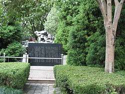
- Opium War Memorial (Zhushan Park) (鸦片战争遗址公园(竹山公园)) is an urban park at the southwestern corner of Dinghai county town in memory of the battle fought between Zhoushaners and the British around 1840, notably the heroic deeds of three generals, Ge Yunfei, Wang Xipeng and Zheng Guohong.
Notable people
Arts
- He Saifei (何賽飛; born 1963), actress
- Michael Miu (苗僑偉; born 1958), Hong Kong TVB actor
- Sanmao (三毛; 1943–1991), Taiwanese writer
- Wong Kar-wai (王家衛; born 1958), Hong Kong filmmaker
- Wu Shanzhuan (吳山專; born 1960), artist
Politics
- Chai Songyue (柴松嶽; born 1941), former governor of Zhejiang Province (1997–2002)
- Ding Guangxun (丁光訓, 1915–2012), vice-chairman of the 10th CPPCC National Committee, chairman of the China Amity Foundation
- Qiao Shi (喬石; born 1924), former chairman of People's Congress of the People's Republic of China
- Tung Chee Hwa (董建華; born 1937), eldest son of Dong Haoyun, the first elected Chief Executive of the Hong Kong Special Administrative Region of the People's Republic of China
Others
- Ge Yunfei (葛雲飛; 1789–1841), general in the First Opium War
- Dong Haoyun (董浩雲; 1912–1982), shipping tycoon and founder of several major shipping companies
- Yang Yuanqin (楊元慶; born 1964), chief executive officer of Lenovo
Education

Zhoushan City has 111 licensed kindergartens, 62 primary schools, 34 middle schools, 16 high schools, 7 vocational schools, and 3 higher-educational level colleges and universities.[22] Zhoushan High School, Dinghai First High School, Putuo High School, Daishan High School, and Shengsi High School are province level key public high schools. Putuo No.2 Middle School is one of the noted Middle Schools in the Putuo District. Nanhai Experimental School, located at Lincheng Sub-District of Dinghai and established in 2001, is a major private school. Zhejiang Ocean University is the only full-fledged university in the city. Zhejiang University Zhoushan Campus is currently under construction and scheduled to complete in 2015.
Twin towns – Sister cities
-
 City of Greater Geraldton, Western Australia, Australia
 -
 Cangzhou, Hebei
 -
 Richmond, California, United States
 -
 La Spezia, Province of La Spezia, Italy
 -
 Szekszárd, Tolna County, Hungary
 -
 Tinos, Cyclades, Greece
 -
 Kesennuma, Miyagi, Japan
 -
 Ganghwa County, Incheon Metropolitan City, South Korea
 - Gokseong County, South Jeolla Province, South Korea
- Sacheon City, South Gyeongsang Province, South Korea
-
 Imus, Cavite, Philippines
 - Zamboanga City, Philippines
Notes
- ↑ A zhōu is a particular kind of "leaf"-shaped Chinese boat that is low, thin, long, and curving slightly from bow to stern. Shān is typically translated as "mountain" but also frequently refers to ranges (Chinese uses few plural forms), hills (properly 小山 or "little mountains"), and to islands ("mountains-in-the-sea") in proper names.
- ↑ The term "city" used here is a translation of a Chinese administrative level that originally referred to major markets. It does not refer to a single city covering all of the archipelago's islands but to a particular level of autonomy and privileges enjoyed by the prefectural government on account of its relative urbanization. Another prefecture-level "city" consisting entirely of islands is Hainan's Sansha Prefecture.
References
Citations
- ↑ http://www.zstj.net/ShowArticle.aspx?ArticleID=6681. Missing or empty
|title=(help) - ↑ Wang, Wenhong. 舟山岛的地名来历. Sina Blog (in Chinese). Retrieved 27 December 2014.
- ↑ Gernet 2002, pp. 182–183.
- ↑ David McCraw (2003). "Magic Precincts: Five Buddhist temples and How They Grew" (PDF). Center for Chinese Studies, University of Hawai‘i at Mānoa. Archived from the original (PDF) on 18 September 2009.
- ↑ Gernet 2002, p. 422.
- ↑ Spence 1991, p. 120.
- ↑ See "Ch'ien lung's Letter to George III," http://web.jjay.cuny.edu/~jobrien/reference/ob41.html.[]
- ↑ Spence 1991, p. 156.
- ↑ Welsh 1997, p. 108.
- ↑ Spence 1991, p. 157.
- ↑ Walter Graham Blackie (1875). The Imperial Gazetteer. London. p. 696..
- ↑ "2008舟山统计年鉴". Zstj.net. Retrieved 2015-12-23.
- ↑ "2008舟山统计年鉴". Zstj.net. Retrieved 2015-12-23.
- ↑ ( 2014年01月29日 10:15 ). "浙江舟山群岛新区". Zhoushan.cn. Retrieved 2015-12-23.
- 1 2 "舟山市2012年国民经济和社会发展统计公报". Zsdx.gov.cn. 2013-03-20. Archived from the original on 5 January 2016. Retrieved 2015-12-23.
- ↑ document.write(getNowDate());. "舟山网·大海网:宁波舟山港货物吞吐量全球第一". Zhoushan.cn. Retrieved 2015-12-23.
- ↑ document.write(getNowDate()); (2014-01-10). "舟山网·大海网:带你认识一个全新的国道". Zhoushan.cn. Retrieved 2015-12-23.
- ↑ "BRT来了 舟山快速公交一号线指南-定海新闻网". Dhnews.zjol.com.cn. Retrieved 2015-12-23.
- ↑ "舟山市2012年国民经济和社会发展统计公报". Stats-sh.gov.cn. 2013-04-11. Archived from the original on 4 March 2016. Retrieved 2015-12-23.
- ↑ Archived 14 June 2012 at the Wayback Machine.
- ↑ Archived 30 May 2012 at the Wayback Machine.
- ↑ "舟山教育网". Zsjy.gov.cn. Retrieved 2015-12-23.
Bibliography
-
 This article incorporates text from The Imperial Gazetteer, by Walter Graham Blackie, a publication from 1875 now in the public domain in the United States.
 - Gernet, Jacques (2002). A History of Chinese Civilization. translated by J.R. Foster and Charles Hartmann (2nd ed.). New York: Cambridge University Press. ISBN 0-521-49781-7.
- Spence, Jonathan (1991). The Search for Modern China. New York: W. W. Norton & Company. ISBN 0-393-30780-8.
- Welsh, Frank (1997). A History of Hong Kong (revised ed.). London: HarperCollins Publishers. ISBN 0-00-638871-X.
Further reading
- China. Statistical Dept (1880). Special catalogue of the Ningpo collection of exhibits for the international fishery exhibition, Berlin, 1880: Preceded by a description of the fisheries of Ningpo and the Chusan Archipelago. SHANGHAI: STATISTICAL DEPARTMENT OF THE INSPECTORATE GENERAL: Statistical Dept. p. 132. Retrieved 1 March 2012.(the New York Public Library)(Digitized 2 December 2009)
External links
| Wikimedia Commons has media related to Zhoushan. |
- Government website of Zhoushan (Chinese)
- New Area website of Zhoushan (Chinese)
- Government website of Zhoushan
- 舟山网 (Zhoushan Net) (Chinese): Local news and info
- "Undiscovered Zhoushan" : Maps and tourist information