Zemlyanoy Gorod
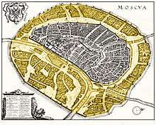
1638 plan of Moscow by Matthäus Merian, with Zemlyanoy Gorod
highlighted
Zemlyanoy Gorod (Земляной город "earthworks town") in 17th-century Moscow was the outer ring of the city, surrounded by ramparts and a moat. It surrounded the older moat built by Aloisio the New in the early 16th century which delimited Bely Gorod.
Historical Zemlyanoy Gorod corresponds to the area now in between the Boulevard Ring and the Garden Ring roads.
Coordinates: 55°45′N 37°37′E / 55.750°N 37.617°E
This article is issued from Wikipedia - version of the 3/24/2013. The text is available under the Creative Commons Attribution/Share Alike but additional terms may apply for the media files.