Semigallia
| Semigallia (Zemgale) | ||
| Region | ||
 | ||
|
||
| Country | Latvia | |
|---|---|---|
| Borders on | Courland (west), Lithuania (south), Gulf of Riga (north), Vidzeme (northeast), Latgale (east) | |
| Rivers | Daugava, Lielupe | |
| Capital | Jelgava | |

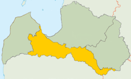
Semigallia, also spelled Semigalia, (Latvian: Zemgale; German: Semgallen; Polish: Semigalia; Lithuanian: Žiemgala; Livonian: Zemgāl) is a historical region of Latvia, sometimes also including a part of Lithuania. It lies in the middle of the southern part of Latvia.
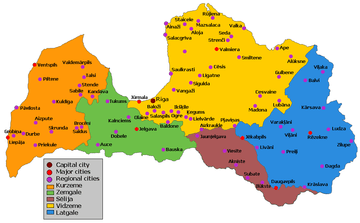
Semigallia is recognized along with Selonia as one region, although sometimes Selonia is perceived as a separate fifth region. Also on the coat of arms of Latvia Semigallia is represented along with Courland (Kurzeme), due to the historical connection between the two regions. Semigallia borders other historical Baltic regions such as Vidzeme (southern part of former Swedish Livonia) to the northeast, Lithuanian Samogitia to the south, Courland to the west and Latgale to the east as well as Gulf of Riga to the north. The geography of Semigallia consists mostly of plains and some hills. The Lielupe is the most important river after the Daugava. The major town is Jelgava (German: Mitau), the former capital of the united Duchy of Courland and Semigallia.
The Semigallia region consists of the city of Jelgava and the municipalities of Auce, Baldone, Dobele, Engure, Iecava, Jaunpils, Jelgava, Ozolnieki, Rundāle, Tērvete, Tukums and Vecumnieki.
History
Within Latvia, Semigallia has the status of one of the four historical and cultural regions of Latvia, the region takes its name from the Baltic people known as Semigallians. Since the 13th century Selonia has been included as part of Semigalia, and comprises the eastern part of the current electoral district of Zemgale. It takes its name from the Baltic tribe of the Selonians. Traditional Selonia also includes a portion of northeastern Lithuania.
The Semigallian language was spoken in the region until around the 16th century.
Between 1795 and 1918 Semigalia was included within the government of Courland and passed with that territory to independent Latvia after World War I.
References
- Žiemgaliai. The Semigallians. Baltic archaeological Exhibition Catalogue. Lietuvos nacionalinis muziejus, Latvijas Vēstures muzejs, 2005
- Ilona Vaškevičiūtė. The Semigallian cultural area
Coordinates: 56°40′N 23°30′E / 56.667°N 23.500°E