Zduńska Wola County
| Zduńska Wola County Powiat zduńskowolski | |||
|---|---|---|---|
| County | |||
| |||
 Location within the voivodeship | |||
 Division into gminas | |||
| Coordinates (Zduńska Wola): 51°36′N 18°58′E / 51.600°N 18.967°ECoordinates: 51°36′N 18°58′E / 51.600°N 18.967°E | |||
| Country |
| ||
| Voivodeship | Łódź | ||
| Seat | Zduńska Wola | ||
| Gminas |
Total 4 (incl. 1 urban)
| ||
| Area | |||
| • Total | 369.19 km2 (142.55 sq mi) | ||
| Population (2006) | |||
| • Total | 67,704 | ||
| • Density | 180/km2 (470/sq mi) | ||
| • Urban | 46,377 | ||
| • Rural | 21,327 | ||
| Car plates | EZD | ||
| Website | http://www.powiatzdunskowolski.pl | ||

Zduńska Wola County (Polish: powiat zduńskowolski) is a unit of territorial administration and local government (powiat) in Łódź Voivodeship, central Poland. It came into being on January 1, 1999, as a result of the Polish local government reforms passed in 1998. Its administrative seat and largest town is Zduńska Wola, which lies 41 kilometres (25 mi) south-west of the regional capital Łódź. The only other town in the county is Szadek, lying 12 km (7 mi) north of Zduńska Wola.
The county covers an area of 369.19 square kilometres (142.5 sq mi). As of 2006 its total population is 67,704, out of which the population of Zduńska Wola is 44,370, that of Szadek is 2,007, and the rural population is 21,327.
Neighbouring counties
Zduńska Wola County is bordered by Poddębice County to the north, Łask County to the east and Sieradz County to the west.
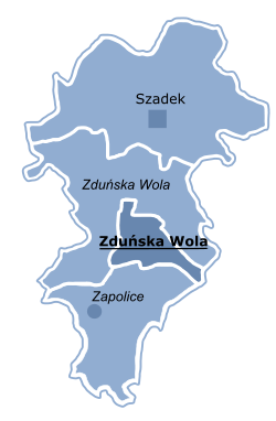
Administrative division
The county is subdivided into four gminas (one urban, one urban-rural and two rural). These are listed in the following table, in descending order of population.
| Gmina | Type | Area (km²) |
Population (2006) |
Seat |
| Zduńska Wola | urban | 24.6 | 44,370 | |
| Gmina Zduńska Wola | rural | 111.5 | 11,256 | Zduńska Wola * |
| Gmina Szadek | urban-rural | 152.0 | 7,350 | Szadek |
| Gmina Zapolice | rural | 81.1 | 4,728 | Zapolice |
| * seat not part of the gmina | ||||
References
Seat: Zduńska Wola (urban gmina) | ||
| Urban-rural gmina |  | |
| Rural gminas | ||
| City counties |
|  |
|---|---|---|
| Land counties | ||