Zayü County
| Zayü County 察隅县 • རྫ་ཡུལ་རྫོང་། | |
|---|---|
| County | |
.png) Location of Zayü County within Nyingchi Prefecture, Tibet, and the PRC | |
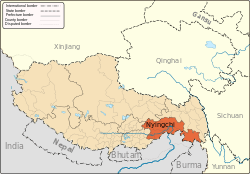
 Zayü Location in Tibet | |
| Coordinates: 28°40′N 97°28′E / 28.667°N 97.467°E | |
| Country | People's Republic of China |
| Region | Tibet |
| Prefecture | Nyingchi |
| Area | |
| • Total | 31,305 km2 (12,087 sq mi) |
| Elevation | 2,330 m (7,640 ft) |
| Population (2000) | |
| • Total | 25,000 |
| • Density | 0.80/km2 (2.1/sq mi) |
| Time zone | China Standard (UTC+8) |
Zayü County, or Chayu County, is a county of the Nyingtri Prefecture in the southeast of the Tibet Autonomous Region, bordering India and Burma to the south and Yunnan province to the southeast.
Chinese claims include parts of Arunachal Pradesh, south of the McMahon Line, what was casus belli for the 1962 Sino-Indian War.
Geography and climate
Besides India, Burma, and Yunnan, Zayü borders Zogang County to the north and Mêdog County to the southwest. It has an area of 31,305 square kilometres (12,087 sq mi),[1] and is located in an area of highly varying topography, including deep canyons such as that of the Nu River. Elevations generally decrease from northwest to southeast, with a maximal variation of 3,600 metres (11,800 ft): in the county, areas near the southern border have an elevation of 1,400 metres (4,600 ft),[1] while there are 10 peaks over 5,000 metres (16,000 ft),[1] the highest being Kawagarbo in the Meili Xue Shan at 6,740 metres (22,110 ft). The county has an average elevation of 2,300 metres (7,500 ft).[1]
Owing to its moderate elevation (for Tibet), Zayü has a subtropical highland climate (Köppen Cwb), a rarity in Tibet, with mild and quite dry winters, and warm, rainy summers. The rainy season lasts from March to September, and June through August each average more than 20 days of rainfall per month. The monthly daily average temperature ranges from 5.5 °C (41.9 °F) in January to 19.9 °C (67.8 °F) in July, and the annual mean is 13.09 °C (55.6 °F). The frost-free period is 280 days annually. Here, the diurnal temperature range is not large, maxing out at 13.5 °C (24.3 °F) in November. Its climate is well-suited to support a variety of agricultural and forestry products.[1]
| Climate data for Zayü (1971−2000) | |||||||||||||
|---|---|---|---|---|---|---|---|---|---|---|---|---|---|
| Month | Jan | Feb | Mar | Apr | May | Jun | Jul | Aug | Sep | Oct | Nov | Dec | Year |
| Record high °C (°F) | 19.0 (66.2) |
21.6 (70.9) |
24.2 (75.6) |
28.9 (84) |
30.2 (86.4) |
31.6 (88.9) |
31.9 (89.4) |
31.1 (88) |
30.3 (86.5) |
29.5 (85.1) |
22.8 (73) |
19.8 (67.6) |
31.9 (89.4) |
| Average high °C (°F) | 11.4 (52.5) |
12.2 (54) |
14.0 (57.2) |
17.0 (62.6) |
21.7 (71.1) |
24.0 (75.2) |
24.7 (76.5) |
24.9 (76.8) |
23.3 (73.9) |
20.4 (68.7) |
16.8 (62.2) |
13.2 (55.8) |
18.6 (65.5) |
| Daily mean °C (°F) | 5.5 (41.9) |
6.7 (44.1) |
8.8 (47.8) |
11.7 (53.1) |
16.1 (61) |
19.1 (66.4) |
19.9 (67.8) |
19.8 (67.6) |
18.4 (65.1) |
14.5 (58.1) |
10.0 (50) |
6.6 (43.9) |
13.1 (55.6) |
| Average low °C (°F) | −0.4 (31.3) |
1.2 (34.2) |
3.6 (38.5) |
6.4 (43.5) |
10.6 (51.1) |
14.3 (57.7) |
15.2 (59.4) |
14.8 (58.6) |
13.6 (56.5) |
8.7 (47.7) |
3.3 (37.9) |
0.0 (32) |
7.6 (45.7) |
| Record low °C (°F) | −5.5 (22.1) |
−5 (23) |
−2.4 (27.7) |
−0.2 (31.6) |
2.5 (36.5) |
8.0 (46.4) |
9.5 (49.1) |
8.5 (47.3) |
6.0 (42.8) |
0.9 (33.6) |
−2.9 (26.8) |
−4.4 (24.1) |
−5.5 (22.1) |
| Average precipitation mm (inches) | 14.1 (0.555) |
30.7 (1.209) |
91.4 (3.598) |
129.4 (5.094) |
74.0 (2.913) |
83.0 (3.268) |
108.4 (4.268) |
108.4 (4.268) |
76.5 (3.012) |
61.3 (2.413) |
18.1 (0.713) |
12.4 (0.488) |
807.7 (31.799) |
| Average precipitation days (≥ 0.1 mm) | 6.2 | 10.6 | 17.4 | 18.4 | 17.9 | 20.4 | 22.3 | 22.7 | 19.0 | 11.8 | 5.4 | 3.0 | 175.1 |
| Source: Weather China[1] | |||||||||||||