Zarasai District Municipality
| Zarasai District Municipality Zarasų rajono savivaldybė | ||
|---|---|---|
| Municipality | ||
| ||
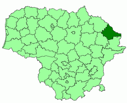 Location of Zarasai district municipality within Lithuania | ||
| Country |
| |
| Ethnographic region | Aukštaitija | |
| County |
| |
| Capital | Zarasai | |
| Elderships | 10 | |
| Area | ||
| • Total | 1,334 km2 (515 sq mi) | |
| Area rank | 24th | |
| Population (2001 census) | ||
| • Total | 22,900 | |
| • Rank | 52nd | |
| • Density | 17/km2 (44/sq mi) | |
| • Density rank | 58th | |
| Time zone | EET (UTC+2) | |
| • Summer (DST) | EEST (UTC+3) | |
| Telephone code | 385 | |
| Major settlements | ||
| Website |
www | |

Zarasai District Municipality is one of 60 municipalities in Lithuania. It borders with Latvia and Belarus.
Local government units
The district has the following localities:
- 2 cities (miestas): Zarasai (capital) and Dusetos
- 3 towns (miestelis): Antalieptė, Salakas, and Turmantas
- about 800 rural settlements (villages and single-family farmsteads)
Geography and attractions
30% of the territory is covered by forests (about 65% of those are pine forests), about 10% by lakes. The district has about 300 lakes. The most famous lake is Lake Sartai for its winter horse races. Part of the biggest lake in Lithuania, Lake Drūkšiai, is also in the district. Other three lakes are among the ten largest lakes in Lithuania. There are 20 artificial lakes, the biggest one is Antalieptė Lagoon (Lithuanian: Antalieptės marios). It is a unique artificial lake in Lithuania. It was formed when a dam on Šventoji River was built and 27 different lakes joined to form one lagoon. It has about 50 islands. There are 8 rivers, the longest is Šventoji River (almost 45 km in the district). The district has two regional parks, Sartai and Gražutė.
The district is rich in beautiful nature and could become a tourist destination. However, the geographic location is very inconvenient. Zarasai district municipality is away from major highways. Also, it is quite far away from the capital, Vilnius. Vilnians would rather choose numerous lakes in Molėtai district municipality or Aukštaitija National Park for recreation.
The district has many hill forts built in the 9-12th centuries. They were used for defence against Livonian Order attacking from Daugavpils.
The oldest tree in Lithuania Stelmužė Oak grows in the district.
Nature and geography
 Smalvas
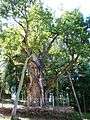
 Landscape near Turmantas
| Municipalities |  | |
|---|---|---|
| Cities | ||
| Towns | ||
| Villages | ||
Coordinates: 55°43′52″N 26°11′17″E / 55.73111°N 26.18806°E