Zachary, Louisiana
| Zachary, Louisiana | |
| City | |
| Country | United States |
|---|---|
| State | Louisiana |
| Parish | East Baton Rouge |
| Elevation | 102 ft (31.1 m) |
| Coordinates | 30°39′18″N 91°09′24″W / 30.65500°N 91.15667°WCoordinates: 30°39′18″N 91°09′24″W / 30.65500°N 91.15667°W |
| Area | 23.96 sq mi (62.1 km2) |
| - land | 23.93 sq mi (62 km2) |
| - water | 0.03 sq mi (0 km2), 0.13% |
| Population | 14,960 (2010) |
| Density | 625.1/sq mi (241.4/km2) |
| Timezone | CST (UTC-6) |
| - summer (DST) | CDT (UTC-5) |
| ZIP code | 70791 |
| Area code | 225 Exchanges: 654,658 |
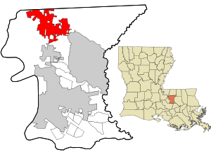 Location in East Baton Rouge Parish and the state of Louisiana | |
| Website: www | |
Zachary is a city in the East Baton Rouge parish of Louisiana in the United States. It lies 16 miles (26 km) north of the city of Baton Rouge, and had a population of 14,960 at the 2010 census,[1] up from 11,275 at the 2000 census.
History

Much of the land which the city now occupies was part of a 160-acre (65 ha) farm owned by Darel Zachary (1827-1907).[2] In the 1880s, Zachary sold his land to the Illinois Central Railroad, who built a track and a depot on it.[3] A village quickly grew up around the depot, which came to be called "Zachary" after the original farmer. Zachary's first post office was opened in 1885, and it was incorporated as a city on August 2, 1889,[4] with Thomas Edward McHugh as its first mayor.[5] A fire devastated the city in 1903, supposedly caused by a greengrocer trying to flame-ripen his bananas. The "historic village" at the center of the city is composed of buildings which either survived the fire, or were built shortly after it, the oldest (excluding the depot) being the 1898 Allison House. The first census was carried out in 1914 and reported just 419 residents. Zachary was the first city in Louisiana since the Reconstruction Era to elect a Republican as mayor, Jack Louis Breaux.[5]
Geography
Zachary is located in northern East Baton Rouge Parish at 30°39′18″N 91°9′24″W / 30.65500°N 91.15667°W (30.655085, −91.156781).[6] It is bordered to the north by the city of Slaughter, to the east by Central, and to the south by Baker. Louisiana Highway 19 passes through the city, leading north 5 miles (8 km) to the center of Slaughter and south 9 miles (14 km) to U.S. Route 61 in the northern part of Baton Rouge.
According to the United States Census Bureau, Zachary has a total area of 24.0 square miles (62.1 km2), of which 23.9 square miles (62.0 km2) is land and 0.04 square miles (0.1 km2), or 0.13%, is water.[1]
Climate
| Climate data for Zachary | |||||||||||||
|---|---|---|---|---|---|---|---|---|---|---|---|---|---|
| Month | Jan | Feb | Mar | Apr | May | Jun | Jul | Aug | Sep | Oct | Nov | Dec | Year |
| Average high °F (°C) | 54.7 (12.6) |
61.8 (16.6) |
70 (21) |
77.1 (25.1) |
83.7 (28.7) |
90.5 (32.5) |
91.6 (33.1) |
90.4 (32.4) |
85.1 (29.5) |
78.1 (25.6) |
69.1 (20.6) |
60.7 (15.9) |
76.1 (24.5) |
| Average low °F (°C) | 34.1 (1.2) |
39.9 (4.4) |
49.1 (9.5) |
56.4 (13.6) |
63 (17) |
71.5 (21.9) |
72.8 (22.7) |
71.6 (22) |
67.5 (19.7) |
54.6 (12.6) |
48.1 (8.9) |
38.1 (3.4) |
55.6 (13.1) |
| Average precipitation inches (mm) | 5.8 (147) |
5.3 (135) |
4.9 (124) |
5.1 (130) |
5.5 (140) |
6 (150) |
5.2 (132) |
5.7 (145) |
4.8 (122) |
4.9 (124) |
4.2 (107) |
5.3 (135) |
62.6 (1,590) |
| Source: Weatherbase[7] | |||||||||||||
Demographics
| Historical population | |||
|---|---|---|---|
| Census | Pop. | %± | |
| 1900 | 465 | — | |
| 1910 | 419 | −9.9% | |
| 1920 | 524 | 25.1% | |
| 1930 | 626 | 19.5% | |
| 1940 | 730 | 16.6% | |
| 1950 | 1,542 | 111.2% | |
| 1960 | 3,268 | 111.9% | |
| 1970 | 4,964 | 51.9% | |
| 1980 | 7,297 | 47.0% | |
| 1990 | 9,036 | 23.8% | |
| 2000 | 11,275 | 24.8% | |
| 2010 | 14,960 | 32.7% | |
| Est. 2015 | 16,448 | [8] | 9.9% |
As of the census[10] of 2000, there were 11,275 people, 3,836 households, and 3,064 families residing in the city. The population density was 475.2 people per square mile (183.5/km²). There were 4,076 housing units at an average density of 171.8 per square mile (66.3/km²). The racial makeup of the city was 69.76% White, 28.72% African American, 0.19% Native American, 0.46% Asian, 0.32% from other races, and 0.55% from two or more races. Hispanic or Latino of any race were 0.72% of the population.
There were 3,836 households out of which 43.4% had children under the age of 18 living with them, 60.2% were married couples living together, 15.6% had a female householder with no husband present, and 20.1% were non-families. 17.5% of all households were made up of individuals and 7.4% had someone living alone who was 65 years of age or older. The average household size was 2.88 and the average family size was 3.26.
The population was spread out across age groups with 30.0% under 18, 8.8% from 18 to 24, 29.5% from 25 to 44, 20.8% from 45 to 64, and 10.8% who were 65 or older. The median age was 34 years. For every 100 females, there were 90.5 males. For every 100 females age 18 and over, there were 86.7 males in the same age range.
The median income for a household in the city was $49,669, and the median income for a family was $57,389. Males had a median income of $45,092 versus $25,143 for females. The per capita income for the city was $18,554. About 6.9% of families and 9.1% of the population were below the poverty line, including 12.6% of those under age 18 and 7.9% of those age 65 or over.
Notable people
- Jack Breaux (1926–1980), first Republican mayor in Louisiana since Reconstruction
- Kedrick Brown (born 1981), Zachary High School basketball player who was the first Junior College player to be selected in the NBA draft
- Donna Douglas, actress famous for playing Elly May Clampett on The Beverly Hillbillies situation comedy from 1962 to 1971; born in 1933 in nearby Pride, Louisiana
- Trindon Holliday (born 1986), wide receiver and return specialist for the Tampa Bay Buccaneers
- Johnny Huggins (born 1976), American football player
- John Neely Kennedy (born 1951), Louisiana state treasurer
- Tom Ed McHugh (born 1943), East Baton Rouge Parish Mayor-President (1989–2000)
- Roderick Mullen, NFL cornerback
- Bob Odom (born 1935), former Louisiana agriculture commissioner
- Richard Stalder (born 1951), former secretary of the Louisiana Department of Public Safety and Corrections
- Doug Williams, former NFL quarterback for the Washington Redskins and MVP of Super Bowl XXII
- Robert Pete Williams (1914–1980), blues musician
- Gus Young (1909–1969), co-led the first voters registration drive (1938)
Education
Zachary residents are served by the Zachary Community School Board.
The Zachary Community School System separated from the East Baton Rouge Parish School System in 2003.[11]
References
- 1 2 "Geographic Identifiers: 2010 Demographic Profile Data (G001): Zachary city, Louisiana". American Factfinder. U.S. Census Bureau. Retrieved February 3, 2016.
- ↑ "History of Zachary" Town Square Publications, 2005.
- ↑ Futch, C. J. (March 25, 2015). "Archivist Retraces Zachary's History from Original Train Depot, Revolution, Resurrection from Fire". The Advocate. Retrieved February 3, 2016.
- ↑ Margaret Harmon, historian and archivist for the Zachary United Methodist Church (September 2011), "A Look Back at Our History"
- 1 2 "History of Zachary". City of Zachary. Retrieved February 3, 2016.
- ↑ "US Gazetteer files: 2010, 2000, and 1990". United States Census Bureau. February 12, 2011. Retrieved 2011-04-23.
- ↑ "Weatherbase: Historical Weather for Zachary, Louisiana". Weatherbase. 2011. Retrieved on November 24, 2011.
- ↑ "Annual Estimates of the Resident Population for Incorporated Places: April 1, 2010 to July 1, 2015". Retrieved July 2, 2016.
- ↑ "Census of Population and Housing". Census.gov. Retrieved June 4, 2015.
- ↑ "American FactFinder". United States Census Bureau. Retrieved 2008-01-31.
- ↑ "Zachary tax vote test of independence ideal." The Advocate, November 13, 2003.
External links
- City of Zachary official website
- Zachary Chamber of Commerce
- Zachary Community School District
- Zachary High School
- Zachary Police Department
Municipalities and communities of East Baton Rouge Parish, Louisiana, United States | ||
|---|---|---|
| Cities | 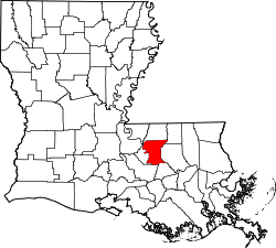 | |
| CDPs | ||
| Unincorporated communities | ||