Yerba Buena Cove
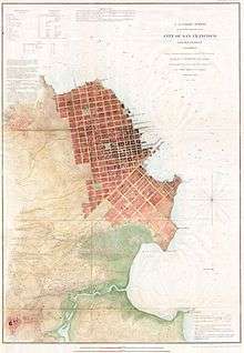
The Shoreline of San Francisco in 1853. Since 1849, Yerba Buena Cove has been filled in between Clarks Point and the Market Street Wharf. What remains was south of that wharf to Rincon Point.
Yerba Buena Cove was a cove on San Francisco Bay where the Mexican pueblo of Yerba Buena was located. It lay between Clarks Point to the north (southeast of Telegraph Hill, near the corner of Broadway and Battery Streets) and Rincon Point to the south (near the corner of Harrison and Spear Streets). The beach of the cove was set back as far as what is now Montgomery Street between Clay and Washington Streets. Between the beginning of the California Gold Rush and 1860 the cove was filled in, and the downtown of the city of San Francisco built over it.
External links
- Map of San Francisco, Showing Business Section and Waterfront, 1851-52 from ronhenggeler.com, accessed March 31, 2015.
- Yerba Buena Cove, from foundsf.org accessed March 31, 2015
- Maps of Yerba Buena and Yerba Buena Cove
- Yerba Buena Survey Area
Coordinates: 37°47′35″N 122°23′46″W / 37.79306°N 122.39611°W

This article is issued from Wikipedia - version of the 10/10/2016. The text is available under the Creative Commons Attribution/Share Alike but additional terms may apply for the media files.