Yellowknife Highway
| ||||
|---|---|---|---|---|
| Northwest Territories Highway 3 | ||||
| Route information | ||||
| Length: | 338.8 km (210.5 mi) | |||
| Major junctions | ||||
| South end: |
| |||
| North end: |
| |||
| Highway system | ||||
|
Northwest Territories highways
| ||||

Highway 3, known more commonly as the Yellowknife Highway, but also the Great Slave Highway, connects Yellowknife, Northwest Territories to Highway 1, from a junction 188 km (117 mi) north of the Alberta border. Built in 1960, the highway is now completely paved and realigned after years of work concluded in 2006.
The highway also connects with Behchoko (formerly Rae-Edzo) and Fort Providence. From Yellowknife, Highway 4 extends a further 70 km (43 mi) north, also providing access to the seasonal winter roads used by commercial trucking for mine resupply.
Crossing the Mackenzie River (just south of Fort Providence) between 1960 and November 2012 required a ferry service (May–January) and ice bridge (December to March). Transportation was interrupted in the spring for approximately five weeks when the ice bridge became unsafe but ice conditions prevented safe ferry operations. The vessel Merv Hardie served from 1968 to 2012.
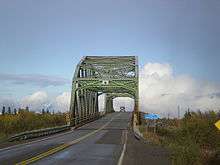
The Deh Cho Bridge opened on November 30, 2012, and replaced the ferry/ice bridge.[1] Trucks pay tolls on northbound crossings, with pre-registered trucks using an electronic device being charged automatically. Private passenger vehicles do not pay a toll. Estimated costs have more than tripled since 2003.[2][3]
References
| Wikimedia Commons has media related to |
- ↑ "Deh Cho Bridge to open Nov. 30". CBC News. November 6, 2012. Retrieved November 8, 2012.
- ↑ CBC News: A closer look at Canada's infrastructure blockbusters. November 16, 2011.
- ↑ A piece of history begins to melt
| Highways | ||
|---|---|---|
| Other roads | ||