Yangpu District
| Yangpu 杨浦区 | |
|---|---|
| District | |
|
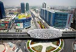
Wujiaochang(五角场) | |
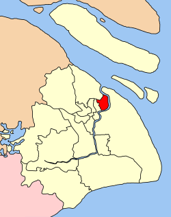 Location within Shanghai | |
| Government[1] | |
| • District Governor | Xinming Jin (CCP) |
| Area[2] | |
| • Total | 60.61 km2 (23.40 sq mi) |
| Population (2010)[3] | |
| • Total | 1,313,222 |
| • Density | 22,000/km2 (56,000/sq mi) |
| Time zone | China Standard Time (UTC+8) |
| Website |
www |
| Chinese names | |||||||||||
| Yangpu District | |||||||||||
|---|---|---|---|---|---|---|---|---|---|---|---|
| Traditional Chinese | 楊浦區 | ||||||||||
| Simplified Chinese | 杨浦区 | ||||||||||
| Literal meaning | Poplar Bank District | ||||||||||
| |||||||||||
| Yangshupu | |||||||||||
| Traditional Chinese | 楊樹浦 | ||||||||||
| Simplified Chinese | 杨树浦 | ||||||||||
| Postal |
Yangtzepoo Yangtszepoo | ||||||||||
| Literal meaning | Poplar Tree Bank | ||||||||||
| |||||||||||
Yangpu District is one of the 19 districts of the Municipality of Shanghai in the China. It is located in northeastern part of downtown Shanghai, bordering the Huangpu River on the east and south, Hongkou District on the west, and Baoshan District in the north. The southern part of Yangpu District is 4 km (2.5 mi) away from the Bund, a major tourist attraction. It is predominantly composed of residential communities, with a total area of 60.61 km2 (23.40 sq mi)[2] and a population of 1.313 million as of 2010.[3] The whole district is divided administratively into 11 resident subdistricts and 1 town.[2]
Name
The name Yangshupu, formerly romanized as Yangtzepoo or Yangtszepoo, is Chinese for "poplar bank" and refers to the creek (t 楊樹浦河, s 杨树浦河, p Yángshùpǔ Hé) running through the area beside present-day Lanzhou Rd (formerly Lay Road)[4] from the Qiu in the north to the Huangpu in the south. The Shanghai Municipal Government contracted the name to Yangpu in 1949.
History
As with most of modern Shanghai, the territory of Yangpu has been formed by sediments deposited by the Yangtze River over many centuries. It was probably in the shallows of the East China Sea as late as the Tang Dynasty. During the Northern Song, the Wuyu River (吴淤江) entered the sea somewhere around modern Wujiaochang (五角场). Daoist and Buddhist temples are known to have been established in the vicinity around this time. In 1404, the Huangpu River shifted to its present course, entering the Yangtze River around Wusong. Toward the end of the Ming Dynasty, villages along the river flourished, engaging in agriculture, banking, textiles and water-borne trade.
In 1842, the Treaty of Nanking opened Shanghai as a treaty port. In 1899, 10.89 km2 (4.20 sq mi) of what is now the south of modern Yangpu District was partitioned to become part of the International Settlement. Factories were constructed soon after in the area, especially along Yangshupu Road. Textile, paper-making, and shipbuilding industries were established by the early 20th century in what was then organized as part of Hongkew (now Hongkou). In 1929, the Wujiaochang farmers' market ("Pentagon Plaza") was constructed in the north. Later, during the Japanese occupation from 1937 to 1945, barracks and houses were built in the area. The inland part of the former International Settlement in the area made up part of the Shanghai Ghetto. In December 1944, Yangshupu District was established with an area of 7.7 km2 (3.0 sq mi).
Following the Communist conquest of Shanghai in 1949, the area was developed and, over the next few decades, a number of neighboring districts were abolished and annexed to Yangpu. The area was especially used for heavy industries. The district's present territory west of the river was formed after the incorporation of Wujiaochang District from Baoshan County in 1984. In 1993, Yangpu's territories east of the Huangpu River were designated part of the Pudong New District.
Since the beginning of the 21st century, Yangpu District has increasingly developed away from labor-intensive industry towards commerce and high technology: the area around Wujiaochang now boast ten large commercial centers and the research facility on Dalian Road is one of the top 500 in the world. One of the region's largest districts, 15.5 kilometers of the Changbai Gold-Bin River runs through the economically strong center. Yangpu is also home to one of Shanghai's four largest city police departments, a new generation of international community programs in New Jiangwan City, and the most graduates of elite Tongji University in the city.
Transport
Yangpu District is connected to the neighbouring Pudong New Area across the Huangpu River by one bridge, three tunnels, and six ferry lines. These include the Yangpu Bridge, the Xiangyin Road Tunnel, the Dalian Road Tunnel, and the Jungong Road Tunnel. A fourth tunnel, the Yinhang Road Tunnel is currently under construction.
The Inner Ring Road and Middle Ring Road traverse through Yangpu District.
Lines 3, 4, 8, 10 and 12 of the Shanghai Metro serve Yangpu district.
The industrial wharves along the Huangpu which service the industrial centres of Yangpu are being phased out by residential developments on the waterfront.
Education
Situated in northern Yangpu District are three of China's most distinguished universities, Fudan University, Tongji University, University of Shanghai for Science and Technology as well as the Shanghai University of Finance and Economics.
There is also the Shanghai University of Sport.[5]
Subdistricts and town
| Name | Chinese (S) | Hanyu Pinyin | Shanghainese Romanization | Population (2010)[6] | Area (km2) |
|---|---|---|---|---|---|
| Dinghai Road Subdistrict | 定海路街道 | Dìnghǎilù Jiēdào | din he lu ka do | 100,480 | 6.25 |
| Pingliang Road Subdistrict | 平凉路街道 | Píngliánglù Jiēdào | bin lian lu ka do | 85,870 | 3.41 |
| Jiangpu Road Subdistrict | 江浦路街道 | Jiāngpǔlù Jiēdào | kaon phu lu ka do | 95,382 | 2.39 |
| Siping Road Subdistrict | 四平路街道 | Sìpínglù Jiēdào | sy bin lu ka do | 92,505 | 2.64 |
| Kongjiang Subdistrict | 控江路街道 | Kòngjiānglù Jiēdào | khon cian kaon lu ka do | 105,613 | 2.15 |
| Changbai Xincun Subdistrict | 长白新村街道 | Chángbái Xīncūn Jiēdào | tzan baq sin tsen ka do | 70,195 | 3.05 |
| Yanji Xincun Subdistrict | 延吉新村街道 | Yánjí Xīncūn Jiēdào | yi ciq sin tsen ka do | 90,334 | 2.04 |
| Yinhang Subdistrict | 殷行街道 | Yīnháng Jiēdào | in raon ka do | 192,554 | 9.52 |
| Daqiao Subdistrict | 大桥街道 | Dàqiáo Jiēdào | da djio ka do | 124,954 | 4.41 |
| Wujiaochang Subdistrict | 五角场街道 | Wǔjiǎochǎng Jiēdào | ng koq dzan ka do | 149,090 | 7.66 |
| Xinjiangwancheng Subdistrict | 新江湾城街道 | Xīnjiāngwānchéng Jiēdào | sin kaon ue zen ka do | 27,251 | 8.68 |
| Wujiaochang Town | 五角场镇 | Wǔjiǎochǎng Zhèn | ng koq dzan tzen | 178,994 | 8.77 |
Transportation
Metro
Yangpu is currently served by four metro lines operated by Shanghai Metro:
- Line 4 - Dalian Road 12 , Yangshupu Road
- Line 8 - Shiguang Road, Nenjiang Road, Xiangyin Road, Huangxing Park, Middle Yanji Road, Huangxing Road, Jiangpu Road, Anshan Xincun
- Line 10 - Tongji University, Guoquan Road, Wujiaochang, Jiangwan Stadium, Sanmen Road, East Yingao Road, Xinjiangwancheng
- Line 12 - Dalian Road 4 , Jiangpu Park, Ningguo Road, Longchang Road, Aiguo Road, Fuxing Island
See also
References
- ↑ Shanghai Yangpu. "District Governor". Shanghai Yangpu Government. Retrieved 2001-07-29.
- 1 2 3 Shanghai Yangpu. "Geographical Location". Shanghai Yangpu Government. Retrieved 2011-07-29.
- 1 2 上海市杨浦区人民政府主办. 上海市杨浦区2010年第六次全国人口普查主要数据公报 (in Chinese). 上海市杨浦区人民政府主办. Retrieved 2011-07-29.
- ↑ "The Streets of Shanghai". Tales of Old Shanghai. Retrieved 15 January 2015.
- ↑ "Home (Chinese). Shanghai University of Sport. Retrieved on November 11, 2015. "上海市杨浦区长海路399 号 邮编:200438" - English address: "588 Qing Yuan Huan Rd., 200438 Shanghai, China"
- ↑ shi, Guo wu yuan ren kou pu cha ban gong; council, Guo jia tong ji ju ren kou he jiu ye tong ji si bian = Tabulation on the 2010 population census of the people's republic of China by township / compiled by Population census office under the state; population, Department of; statistics, employment statistics national bureau of (2012). Zhongguo 2010 nian ren kou pu cha fen xiang, zhen, jie dao zi liao (Di 1 ban. ed.). Beijing Shi: Zhongguo tong ji chu ban she. ISBN 978-7-5037-6660-2.
- "Yangpu District". Encyclopedia of Shanghai. Shanghai Municipal Government. 2010.
External links
| Wikimedia Commons has media related to Yangpu District. |
-
 Yangpu District travel guide from Wikivoyage
 - Official English-language website
| Administrative divisions |  | ||||||||||
|---|---|---|---|---|---|---|---|---|---|---|---|
| Areas | |||||||||||
| Streets | |||||||||||
| Attractions | |||||||||||
| Culture and demographics | |||||||||||
| Hotels | |||||||||||
| Museums | |||||||||||
| Parks | |||||||||||
| Places of worship |
| ||||||||||
| Skyscrapers | |||||||||||
| Sports venues | |||||||||||
| Transport |
| ||||||||||
| Universities |
| ||||||||||
| Primary and secondary schools |
| ||||||||||
| Sports | |||||||||||
| |||||||||||
Coordinates: 31°18′N 121°33′E / 31.300°N 121.550°E