Xiuyan Manchu Autonomous County
| Xiuyan County 岫岩县 ᠰᡳᡠᠶᠠᠨ ᠰᡳᠶᠠᠨ | |
|---|---|
| Autonomous county | |
岫岩满族自治县 Xiuyan Manchu Autonomous Countyᠰᡳᡠᠶᠠᠨ ᠮᠠᠨᠵᡠ ᠪᡝᠶᡝ ᡩᠠᠰᠠᠩᡤᠠ ᠰᡳᠶᠠᠨ | |
 Location in Anshan City | |
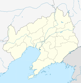 Xiuyan Location of the county seat in Liaoning | |
| Coordinates: 40°17′N 123°17′E / 40.283°N 123.283°ECoordinates: 40°17′N 123°17′E / 40.283°N 123.283°E | |
| Country | People's Republic of China |
| Province | Liaoning |
| Prefecture-level city | Anshan |
| County seat | Xiuyan Town (岫岩镇) |
| Area | |
| • Total | 4,502 km2 (1,738 sq mi) |
| Elevation | 79.6 m (261.2 ft) |
| Population | |
| • Total | 500,000 |
| • Density | 110/km2 (290/sq mi) |
| Time zone | China Standard (UTC+8) |
| Postal code | 114300 |
| Website |
www |
Xiuyan Manchu Autonomous County (simplified Chinese: 岫岩满族自治县; traditional Chinese: 岫岩滿族自治縣; pinyin: Xiùyán Mǎnzú Zìzhìxiàn) is a county in the southeast of Liaoning province, People's Republic of China, and is also one of the 11 Manchu autonomous counties and one of 117 autonomous counties nationally. It is under the administration of and occupies the southernmost portion of Anshan, the centre of which 136 kilometres (85 mi) to the north-northwest, and has a population of 500,000.
Administrative divisions
There are 20 towns and 3 townships under the county's administration.[1]
Towns:
|
|
Townships:
- Hongqiyingzi Township (红旗营子乡)
- Linggou Township (岭沟乡)
- Shaozihe Township (哨子河乡)
Geography and climate
Xiuyan borders Yingkou and Gaizhou to the west, Donggang and Zhuanghe to the south and Haicheng and Liaoyang to the north. Its latitude ranges from 40° 00' to 40° 39' N and longitude 122° 52' to 123° 41' E, and the area is 4,507 km2 (1,740 sq mi). The county's area is dominated by low-lying mountains part of the Changbai Mountains, with the highest peak in the county, Mount Maokui (帽盔山), at 1,141.5 m (3,745 ft), being the highest point in southern Liaoning.[2]
Xiuyan has a monsoon-influenced humid continental climate (Köppen Dwa) characterised by hot, humid summers, due to the monsoon, and rather long, cold, and very dry winters, due to the Siberian anticyclone. The four seasons here are distinctive. A majority of the annual rainfall occurs in July and August. The monthly 24-hour average temperatures ranges from −9.9 °C (14.2 °F) in January to 23.2 °C (73.8 °F) in July, while the annual mean is 7.93 °C (46.3 °F). Due to the mountainous location, temperatures tend to be slightly cooler than areas to the south and west, and summer rainfall is more generous.
| Climate data for Xiuyan (1971−2000) | |||||||||||||
|---|---|---|---|---|---|---|---|---|---|---|---|---|---|
| Month | Jan | Feb | Mar | Apr | May | Jun | Jul | Aug | Sep | Oct | Nov | Dec | Year |
| Record high °C (°F) | 7.4 (45.3) |
13.5 (56.3) |
19.5 (67.1) |
30.4 (86.7) |
34.5 (94.1) |
36.5 (97.7) |
37.7 (99.9) |
35.2 (95.4) |
32.0 (89.6) |
28.1 (82.6) |
19.4 (66.9) |
11.7 (53.1) |
37.7 (99.9) |
| Average high °C (°F) | −3.1 (26.4) |
0.4 (32.7) |
7.1 (44.8) |
15.9 (60.6) |
21.8 (71.2) |
25.5 (77.9) |
27.4 (81.3) |
28.1 (82.6) |
23.9 (75) |
16.8 (62.2) |
7.0 (44.6) |
−0.6 (30.9) |
14.2 (57.5) |
| Daily mean °C (°F) | −9.9 (14.2) |
−6.1 (21) |
1.0 (33.8) |
9.0 (48.2) |
15.2 (59.4) |
20.0 (68) |
23.2 (73.8) |
22.9 (73.2) |
16.8 (62.2) |
9.3 (48.7) |
0.7 (33.3) |
−6.9 (19.6) |
7.9 (46.2) |
| Average low °C (°F) | −15.3 (4.5) |
−11.7 (10.9) |
−4.5 (23.9) |
2.7 (36.9) |
9.1 (48.4) |
15.0 (59) |
19.7 (67.5) |
18.8 (65.8) |
11.2 (52.2) |
3.4 (38.1) |
−4.1 (24.6) |
−11.9 (10.6) |
2.7 (36.9) |
| Record low °C (°F) | −31.5 (−24.7) |
−28.9 (−20) |
−27.2 (−17) |
−8.0 (17.6) |
−1.0 (30.2) |
5.5 (41.9) |
11.2 (52.2) |
6.1 (43) |
−0.5 (31.1) |
−9.8 (14.4) |
−18.8 (−1.8) |
−28.5 (−19.3) |
−31.5 (−24.7) |
| Average precipitation mm (inches) | 6.6 (0.26) |
8.1 (0.319) |
14.0 (0.551) |
37.7 (1.484) |
61.0 (2.402) |
99.4 (3.913) |
222.1 (8.744) |
208.8 (8.22) |
84.1 (3.311) |
46.2 (1.819) |
19.0 (0.748) |
11.0 (0.433) |
818.0 (32.205) |
| Average precipitation days (≥ 0.1 mm) | 3.8 | 3.5 | 5.0 | 7.8 | 9.4 | 11.7 | 16.1 | 12.3 | 7.9 | 6.9 | 5.8 | 3.6 | 93.8 |
| Source: Weather China [2] | |||||||||||||
References
- ↑ 2011年统计用区划代码和城乡划分代码:岫岩满族自治县 (in Chinese). National Bureau of Statistics of the People's Republic of China. Retrieved 2012-07-17.
- 1 2 岫岩 - 气象数据 -中国天气网 (in Chinese). Weather China. Retrieved 2012-07-17.
External links
| Counties |
|    | ||||||||||
|---|---|---|---|---|---|---|---|---|---|---|---|---|
Ethnic minority autonomous areas: Dong · Hui · Korean · Manchu · Miao · Mongol · Tibetan · Tujia · Uyghur · Yao · Yi · Zhuang · Other | ||||||||||||