Xinmin, Liaoning
| Xinmin 新民市 | ||||||||||||||||||||||||||||||||||||||||||
|---|---|---|---|---|---|---|---|---|---|---|---|---|---|---|---|---|---|---|---|---|---|---|---|---|---|---|---|---|---|---|---|---|---|---|---|---|---|---|---|---|---|---|
| County-level city | ||||||||||||||||||||||||||||||||||||||||||
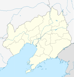 Xinmin Location in Liaoning | ||||||||||||||||||||||||||||||||||||||||||
| Coordinates: 41°59′49″N 122°49′23″E / 41.997°N 122.823°ECoordinates: 41°59′49″N 122°49′23″E / 41.997°N 122.823°E[1] | ||||||||||||||||||||||||||||||||||||||||||
| Country | People's Republic of China | |||||||||||||||||||||||||||||||||||||||||
| Province | Liaoning | |||||||||||||||||||||||||||||||||||||||||
| Sub-provincial city | Shenyang | |||||||||||||||||||||||||||||||||||||||||
| Area[2] | ||||||||||||||||||||||||||||||||||||||||||
| • Total | 3,294 km2 (1,272 sq mi) | |||||||||||||||||||||||||||||||||||||||||
| Population (2010) | ||||||||||||||||||||||||||||||||||||||||||
| • Total | 657,763 | |||||||||||||||||||||||||||||||||||||||||
| • Density | 200/km2 (520/sq mi) | |||||||||||||||||||||||||||||||||||||||||
| Time zone | China Standard (UTC+8) | |||||||||||||||||||||||||||||||||||||||||
| Postal code | 1103XX | |||||||||||||||||||||||||||||||||||||||||
| Shenyang district map |
| |||||||||||||||||||||||||||||||||||||||||
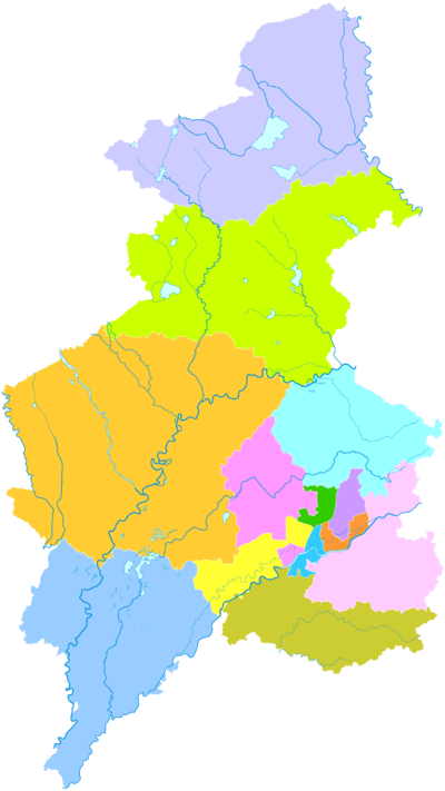
Xinmin (Chinese: 新民; pinyin: Xīnmín; Wade–Giles: Hsin-min) is a county-level city under the jurisdiction of Shenyang, the capital of Liaoning province, People's Republic of China. It contains the westernmost point of and is by far the most spacious of the county-level divisions of Shenyang City.[2] It borders Faku County to the northeast, Shenbei New Area and Yuhong District to the east, Tiexi District to the southeast, and Liaozhong County to the south; it also borders the prefecture-level cities of Jinzhou to the west and Fuxin to the northwest.
Administrative divisions
There are 5 subdistricts, 11 towns, and 13 townships under the city's administration.[3]
Subdistricts:
- Dongcheng Subdistrict (东城街道), Xicheng Subdistrict (西城街道), Liaobin Subdistrict (辽滨街道), Xinliu Subdistrict (新柳街道), Xincheng Subdistrict (新城街道)
Towns:
- Dahongqi (大红旗镇), Liangshan (梁山镇), Daliutun (大柳屯镇), Gongzhutun (公主屯镇), Xinglong (兴隆镇), Xinglongbao (兴隆堡镇), Hutai (胡台镇), Fahaniu (法哈牛镇), Qiandangbao (前当堡镇), Damintun (大民屯镇), Liuhegou (柳河沟镇)
Townships:
- Gaotaizi Township (高台子乡), Jinwutaizi Township (金五台子乡), Hongqi Township (红旗乡), Lutun Township (卢屯乡), Yaobao Township (姚堡乡), Zhoutuozi Township (周坨子乡), Yujiawobao Township (于家窝堡乡), Xinnongcun Township (新农村乡), Dongsheshanzi Township (东蛇山子乡), Taotun Township (陶屯乡), Luojiafangzi Township (罗家房子乡), Sandaogangzi Township (三道岗子乡), Zhangjiatun Township (张家屯乡)
References
- ↑ Google (2014-07-02). "Xinmin" (Map). Google Maps. Google. Retrieved 2014-07-02.
- 1 2 分地区土地面积和人口密度 (2012年末) (in Chinese). Shenyang Statistics Bureau. Retrieved 6 July 2014.
- ↑ 沈阳市-行政区划网
External links
This article is issued from Wikipedia - version of the 10/14/2016. The text is available under the Creative Commons Attribution/Share Alike but additional terms may apply for the media files.